Steinacker (Bergisch Gladbach)
|
Steinacker
City of Bergisch Gladbach
Coordinates: 50 ° 57 ′ 47 " N , 7 ° 11 ′ 45" E
|
||
|---|---|---|
|
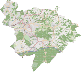
Location of Steinacker in Bergisch Gladbach |
||
|
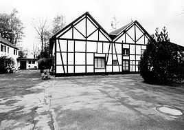
The machine house of the former Lavaisière shaft in Steinacker
|
||
Steinacker is a district in the Moitzfeld district of Bergisch Gladbach .
history
The settlement name Steinacker is to be understood according to its New High German meaning as a stony field , in which the area is located in a stony terrain that is not very fertile and littered with stones.
The current street name Steinacker is mentioned in the original cadastre as a settlement south of the road from Bensberg to Immekeppel (Moitzfeld - Löhe ). The hamlet Steinacker had from the medieval settlement founded Steynacer in great Rodeepoche developed from 1000 to 1300. The name Steinacker first appears in documents in 1413, when Gerhard and Alveradis von Zweiffel donated interest from their Steinacker inheritance to the Dünnwalder Küsterei. In 1487 the Hofschaft Steinacker belonged to the Honschaft Oberhausen , while the estate belonged to the court association of the Immekeppeler Lehnshof. In 1586 two farms are mentioned, one of which belonged to Engel Steinacker and the other to Lurry Heinrich aufm Steinacker. As a result of mining , the population rose sharply in the second half of the 19th century.
The Topographia Ducatus Montani by Erich Philipp Ploennies , Blatt Amt Porz , proves that the living space was categorized as a common courtyard in 1715 and was called Steenacker .
Carl Friedrich von Wiebeking names the court on his charter of the Duchy of Berg in 1789 as Steinaker . It reveals that Steinacker part of that time Honschaft Bensberg in parish Bensberg was.
Under French administration between 1806 and 1813, the Porz office was dissolved and Steinacker was politically assigned to Mairie Bensberg in the canton of Bensberg . In 1816 the Prussians converted the Mairie to the mayor's office in Bensberg in the Mülheim am Rhein district .
The place is recorded on the topographical survey of the Rhineland from 1824 and on the Prussian first survey of 1840 as Steinacker . From 1892 onwards, the Prussian new record was regularly recorded as Steinacker or without a name on measuring table sheets .
Due to the Cologne Act , the city of Bensberg was merged with Bergisch Gladbach to form the city of Bergisch Gladbach with effect from January 1, 1975. Steinacker also became part of Bergisch Gladbach.
| year | Residents | Residential buildings | category | Political / Church affiliation |
|---|---|---|---|---|
| 1822 | 11 | Farm estates | Bensberg mayor's office, Bensberg parish | |
| 1830 | 14th | Farm | Bensberg Mayor's Office, Bensberg Parish | |
| 1845 | 20th | 3 | Farm estates | Bensberg mayor's office, Bensberg parish |
| 1871 | 41 | 3 | Yard | Mayor's office Bensberg |
| 1885 | 77 | 10 | Locality | Mayor's office Bensberg |
| 1895 | 80 | 10 | Locality | Mayor's office Bensberg |
| 1905 | 170 | 15th | Locality | Mayor's office Bensberg |
Mining
The Romans probably already mined in the vicinity of Steinacker. In many places certain traces point to medieval mining. From the middle of the 19th century, industrial mining began at the Weiß mine , the largest deposit of which was in Steinacker.
See also
literature
- Kurt Kluxen : History of Bensberg , Paderborn 1976
- Herbert Stahl : Moitzfeld. Through life, through the year "om Platz" , Bergischer Geschichtsverein Rhein-Berg e. V., Volume 56, Bergisch Gladbach 2009, ISBN 3-932326-56-3 .
Individual evidence
- ^ A b Andree Schulte: Bergisch Gladbach City History in Street Names , published by the Bergisch Gladbach City Archives, Volume 3, and by the Bergisch Geschichtsverein department Rhein-Berg e. V., Volume 11, Bergisch Gladbach 1995, ISBN 3-9804448-0-5 , p. 366 f.
- ↑ a b Rudi Thieser: The Steinacker, a chronicle. Bensberg 2001.
- ^ Wilhelm Fabricius : Explanations for the Historical Atlas of the Rhine Province ; Second volume: The map of 1789. Division and development of the territories from 1600 to 1794 ; Bonn; 1898
- ↑ Alexander A. Mützell: New topographical-statistical-geographical dictionary of the Prussian state . tape 1 . Karl August Künnel, Halle 1821.
- ↑ Friedrich von Restorff : Topographical-statistical description of the Royal Prussian Rhine Province , Nicolai, Berlin and Stettin 1830
- ↑ Overview of the components and list of all the localities and individually named properties of the government district of Cologne: by districts, mayor's offices and parishes, with information on the number of people and the residential buildings, as well as the Confessions, Jurisdictions, Military and former state conditions. / ed. from the Royal Government of Cologne [Cologne], [1845]
- ↑ Royal Statistical Bureau Prussia (ed.): The communities and manor districts of the Prussian state and their population . The Rhine Province, No. XI . Berlin 1874.
- ↑ Königliches Statistisches Bureau (Prussia) (Ed.): Community encyclopedia for the Rhineland Province, based on the materials of the census of December 1, 1885 and other official sources, (Community encyclopedia for the Kingdom of Prussia, Volume XII), Berlin 1888.
- ↑ Königliches Statistisches Bureau (Prussia) (Ed.): Community encyclopedia for the Rhineland Province, based on the materials of the census of December 1, 1895 and other official sources, (Community encyclopedia for the Kingdom of Prussia, Volume XII), Berlin 1897.
- ↑ Königliches Statistisches Bureau (Prussia) (Ed.): Community encyclopedia for the Rhineland Province, based on the materials of the census of December 1, 1905 and other official sources, (Community encyclopedia for the Kingdom of Prussia, Issue XII), Berlin 1909.
Web links
- The largest deposit in the Weiß pit was in Steinacker , accessed on November 27, 2012.

