
Stepenitz (Trave)

.jpg)
The Stepenitz is a right tributary of the Trave in northwest Mecklenburg-Western Pomerania .
River course

The river has its source northwest of Schwerin and the Neumühler See near the Eulenkrug residential area in Brüsewitz and north of a ridge at about 49 m above sea level. NHN . From there it flows first through the Rehmsee and then through the Faulmühle reservoir , the Cramoner See , the Wendelstorfer See and the Groß Eichsener See . Flowing further to the northwest, it takes the Radegast in Börzow and the Maurine four kilometers before Dassow . The river section from Rüting to Dassow is characterized by meanders .
The Stepenitz flows just behind the Dassower bridge in the already Luebeck belonging Dassower lake . Through this lake, in turn, it reaches the Pötenitzer Wiek , a traverse bay between the Priwall and Mecklenburg, in which the Stepenitz flows into the Trave at about sea level ; this in turn reaches the Baltic Sea a few hundred meters further north near the Lübeck district of Travemünde . The length of the river from the source to the mouth in the Dassower See is 52 kilometers. The catchment area has a size of 701 km².
Watershed
The source area of the Stepenitz lies on the North Sea-Baltic Sea watershed . While the Stepenitz flows in a north-westerly direction over the Trave to the Baltic Sea, the water of the Sude , which rises just a few kilometers further south-west and flows in a south-westerly direction, reaches the North Sea over the Elbe .
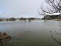
Flood at the confluence of Stepenitz and Radegast in March 2010
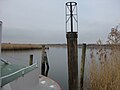
Stepenitz estuary into Dassower See


history
With a declaration of February 16, 1887 to Mecklenburg, the city of Lübeck waived its sovereign rights on the Stepenitz. Until the beginning of the 20th century, the fishing rights of the Stepenitz were below Börzow near the city of Lübeck.
The Stepenitz used to be a border water: on the left bank was the territory of the Hochstift Ratzeburg , later the Principality of Ratzeburg in the partial duchy of Mecklenburg-Strelitz , and on the right bank the partial duchy of Mecklenburg-Schwerin .
Web links
Individual evidence
- ↑ a b Minister for Building, Regional Development and Environment (Ed.): Water quality report 1994 , Schwerin 1996, p. 16
- ^ German Hydrological Yearbook Coastal Area of the Baltic Sea 2005. (PDF) State Office for Environment and Nature Mecklenburg-Western Pomerania, accessed on October 4, 2017 (German, at: dgj.de).
- ↑ Official maps and origin of the Stepenitz , Freimüthiges Abendblatt, Schwerin, vol. 17/1835 ( digitized ; PDF; 112 kB) and Environment Minister of the State of Mecklenburg-Western Pomerania: Water quality report 1993 , Schwerin 1994, p. 58