Stepenitz (Elbe)
| Stepenitz | ||
|
Stepenitz at the Marienfließ monastery |
||
| Data | ||
| Water code | EN : 5914 | |
| location | Germany , Brandenburg | |
| River system | Elbe | |
| Drain over | Elbe → North Sea | |
| River basin district | Elbe | |
| source | 5 km southeast of Meyenburg | |
| Source height | approx. 110 m | |
| muzzle | At Wittenberge in the Elbe coordinates: 52 ° 59 '17 " N , 11 ° 45' 50" E 52 ° 59 '17 " N , 11 ° 45' 50" E
|
|
| length | 85.1 km | |
| Catchment area | 1299 km² (with Karthane) 862.2 km² (without Karthane) |
|
| Discharge at the Wolfshagen A Eo gauge : 570 km² Location: 35.9 km above the mouth |
NNQ (July 27, 2006) MNQ 1978–2014 MQ 1978–2014 Mq 1978–2014 MHQ 1978–2014 HHQ (June 12, 1993) |
612 l / s 1.1 m³ / s 3.24 m³ / s 5.7 l / (s km²) 18.1 m³ / s 52.8 m³ / s |
| Left tributaries | Dömnitz , Panke , Jeetzbach , Karthane | |
| Right tributaries | Schlatbach | |
| Small towns | Meyenburg , Putlitz , Perleberg , Wittenberge | |
| Communities | Great Pankow | |
The Stepenitz is an approximately 84 km long, sand and clay shaped lowland river and right tributary of the Elbe in Brandenburg .
The largest tributaries of the Stepenitz, whose catchment area covers around 1,299 km², are the Dömnitz , Schlatbach , Jeetzbach and Karthane . About 30.8 km² of the catchment area extend into the southwest of Mecklenburg-Western Pomerania .
The Stepenitz is considered to be one of the cleanest rivers in Germany and is largely undeveloped in the upper reaches. In the “Elblachs 2000” project, the Stepenitz and its tributaries form the central water system. The river valley was designated as a nature reserve Stepenitz in 2004 .
Course and places
Headwaters
The Stepenitz rises in a northern tip of Brandenburg in the district of Prignitz about five kilometers southeast of Meyenburg .
The source rises on a ridge about 110 m above sea level. NN between the villages of Penzlin , Penzlin-Süd and Schmolde , which belong to Meyenburg , and Warnsdorf and Bruges, which belong to the municipality of Halenbeck-Rohlsdorf . The Elde and the Dosse begin only a few kilometers from the source of the Stepenitz . At the beginning the Elde flows east to Müritz , the Dosse south-east to the Havel and the Stepenitz in the main direction south-west.


course
Below the source, the Stepenitz quickly loses height and flows in a north-westerly direction through Meyenburg. In the village it forms the eastern border of the castle park at Meyenburg Castle . A little further to the west, the river reaches the municipality of Marienfließ with the districts of Krempendorf and Stepenitz . Here it runs close to the Cistercian convent Marienfließ . This oldest nunnery in Prignitz was founded around 1230 and has the preserved brick monastery church from the 13th century .

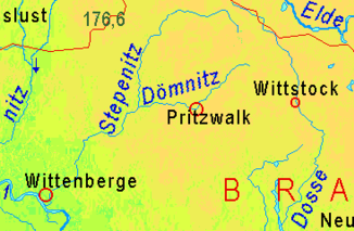
Below the monastery, the river runs through meadows and beech forests with bank breaks, smaller alder breaks and sections similar to alluvial forests . To the east of the Ruhner Mountains , the course bends south. After the town of Telschow, the Stepenitz flows through Putlitz, one of the oldest towns in the Prignitz, to which the towns of Mansfeld and Lockstädt also belong on the further course. Between the places Helle and Wolfshagen in the community of Groß Pankow (Prignitz) the Dömnitz flows from the left . In Wolfshagen the Stepenitzlauf passes the renaissance castle Wolfshagen from 1590. With the waters of the Stepenitz this was originally built as a moated castle by the "noble gentlemen Gans zu Putlitz" . The garden architect Peter Joseph Lenné created a landscape park on both sides of the Stepenitz in the 1850s.
Other Groß Pankow villages on the river are Seddin, Kreuzburg, Rohlsdorf and Klein Linde, before the Schlatbach flows from the right above the Perleberg district of Lübzow . About five kilometers downstream, the Stepenitz encompasses the center of the Westprignitz, Perleberg, with two arms . The historic, restored core of Rolandstadt Perleberg is located on an island in the Stepenitz run. Below Perleberg, the river crosses the Perleberg urban forest in the Perleberger Heide, which is rich in pines, with its valley characterized by meadows . The Jeetzbach flows here from the left . As a result, the flow rate through the Elbe River Landscape Biosphere Reserve is considerable.
The Stepenitz forms the border between the communities of Weisen and Breese , before it touches the traditional Elbe crossing from the Westprignitz to the Altmark with the east of the city of Wittenberge . The river flows into the Elbe together with the Karthane .
Goose tour (bike tour)
The signposted “goose tour” in the river valley leads through the adjacent historical sites for around 70 kilometers from the upper reaches of the Stepenitz near Meyenburg to the mouth. The name of the tour and its pioneering goose logo refer to one of the oldest and most important noble families of the Prignitz, the "Noble Lord" Gans zu Putlitz . Almost all of the cultural and historical sites along the tour are associated with this family. The knight Johann Gans zu Putlitz founded the Marienfließ nunnery in 1230 to secure the border against Mecklenburg . In the Middle Ages, monastic soil was mostly spared from armed conflicts.
Renaturation and nature protection
"Elblachs 2000" program
Until the end of the 19th century, salmon were one of the main sources of income for Elbe-Prignitz fishermen . Since the middle of the 20th century, salmon and sea trout were considered to be extinct in the Stepenitz. Weirs and other hydraulic structures prevented the fish from migrating , and ecological pollution reduced the food supply. Since 2000, the state of Brandenburg has been trying to reintroduce salmon to the Elbe as a "key fish" for fish ecology and fishing with the "Elblachs 2000" program. The program aims to restore self-reproducing salmon and sea trout stocks that can be used for fishing purposes in the Elbe and its tributaries.
In the model experiment, the Stepenitz forms the central body of water. On April 1, 1999, 50,000 young salmon and 10,000 sea trout were placed in the Dömnitz tributary near the Schönhagener Mühle . Since 2002, 54 salmon and 35 sea trout have returned to the Stepenitz system to spawn . This received international attention. Due to the success, the state of Brandenburg started a resettlement program for salmon in 2004, also in the Pulsnitz and the Black Elster . A similar project under the name Lachs 2000 also exists on the Rhine .
For renaturation, dams were dismantled and fish ramps created. In the Schlatbach , a water-rich tributary to the Stepenitz, a weir near Gramzow was replaced by a slat that overcomes a height difference of almost two meters. A basin structure is created with stone bars that allows the fish to migrate even in low water in summer. Artificial spawning grounds have also been created in the upper and lower water of the Gleite. The country released a total of 105,000 sea trout hatchlings in the Schlatbach by 2005.
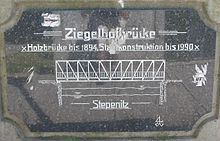
Returning salmon can be seen between mid-November and mid-December. The Ziegelhofbrücke over the Stepenitz at the southern exit of the Perleberg old town is particularly suitable for observation.
Stepenitz nature reserve
The nature reserve Stepenitz covers a total area of approximately 2,500 hectares of several communities along the river of Meyenburg about Putlitz and Triglitz up to Perleberg. The protection purpose is the richly structured flowing water system of the Prignitz plateau and highlands with largely natural or near-natural hydrological conditions, different source horizons and point sources in the area of the valley slopes and floodplain areas near the valley edge .
- Preservation and development of the habitat of wild plant communities, in particular of bog forests, springs and spring meadows, floating leaf and aquatic plant communities, reed beds, sedge beds, grassland, fresh to wet locations with small areas of flood turf and dry grassland.
- Preservation and development of the area as a habitat or retreat and a potential center for re-expansion of wild animal species, in particular for lampreys and fish species tied to the trout and grayling regions as well as various dragonfly species, as spawning waters for amphibians and as a resting, wintering, breeding and feeding area less often , threatened with extinction of birds, including particularly and strictly protected species such as black stork ( Ciconia nigra ), crane ( Grus grus ), wagtail ( Motacilla cinerea ), Kingfisher ( Alcedo atthis ), Green Sandpiper ( Tringa ochropus ) and amphibians such as toad ( Bufo viridis ), Common spadefoot toad ( Pelobates fusces ), little water frog ( Rana lessonae ), tree frog ( Hyla arborea ) and crustaceans such as crayfish ( Astacus astacus ).
- Preservation and development of the running water system for scientific reasons to observe and research the animal and plant communities of a near-natural water system as well as the processes in the context of a near-natural restoration.
- The nature reserve ordinance places particular emphasis on the conservation and development of the populations of otters ( Lutra lutra ), western group ( Cottus gobio ), wolffish ( Cobitis taenia ), salmon ( Salmo salar ), brook lamprey ( Lampetra planeri ), river lamprey ( Lampetra fluviatalis ), small ones River mussel ( Unio crassus ), narrow diaper snail ( Vertigo angustior ), bellied diaper snail ( Vertigo moulinsiana ) and crested newt ( Triturus cristatus ) as animal species according to Annex II of the Fauna-Flora-Habitat Directive, including their important for reproduction, nutrition, migration and wintering Habitats.
The Marienfließ and Quaßliner Moor nature reserves already exist in the region .
Surroundings
From the source to the mouth there are the following named tributaries:
- Schmolder ditch
- Waldhof ditch
- Brew
- Saber
- Krumbach
- Kreuzbach
- Weitgendorfer ditch
- Rotbach
- Zieskenbach
- Sagast
- Cold brook
- Freudenbach
- Doemnitz
- Seddiner Graben
- Panke
- Retziner Mühlbach
- Schlatbach
- pearl
- Jeetzbach
- Herz canal
- Carthans
The towns of Meyenburg , Stepenitz , Putlitz , Wolfshagen , Perleberg and Wittenberge are located along the Stepenitz .
Web links
- Goose tour with detailed history
- Amt Meyenburg, goose tour
- Prignitz Tourist Office
- Ordinance on the “Stepenitz” nature reserve of 23 July 2004
Individual evidence
- ↑ River directory gewnet25 (Version 4.0, April 24, 2014) from the Ministry for Rural Development, Environment and Agriculture of the State of Brandenburg, accessed on May 4, 2015.
- ↑ a b Flood Risk Management Plan (HWRMP) "Stepenitz". (PDF; 1.6 MB) State Office for Environment, Health and Consumer Protection Brandenburg, accessed on November 13, 2018 .
- ↑ Water development concept (GEK) Karthane. (PDF; 263 kB) State Office for the Environment, Health and Consumer Protection Brandenburg, accessed on June 7, 2013 .
- ^ German Hydrological Yearbook Elbe Region, Part III 2014. (PDF) ISSN 0949-3654. Free and Hanseatic City of Hamburg, Hamburg Port Authority, p. 130 , accessed on October 4, 2017 (German, at: dgj.de).
- ↑ Stepenitz (flowing waters - identifier: DE_RW_DEBB5914_211) Water body profile surface water body of the 2nd management plan according to the Water Framework Directive
- ↑ Nature Reserve Ordinance


