
Dassow
| coat of arms | Germany map | |
|---|---|---|

|
Coordinates: 53 ° 55 ' N , 10 ° 59' E |
|
| Basic data | ||
| State : | Mecklenburg-Western Pomerania | |
| County : | Northwest Mecklenburg | |
| Office : | Schönberger Land | |
| Height : | 12 m above sea level NHN | |
| Area : | 66.56 km 2 | |
| Residents: | 4063 (Dec. 31, 2019) | |
| Population density : | 61 inhabitants per km 2 | |
| Postal code : | 23942 | |
| Area code : | 038826 | |
| License plate : | NWM, GDB, GVM, WIS | |
| Community key : | 13 0 74 017 | |
| LOCODE : | DE MVD | |
| Office administration address: | Am Markt 15, 23923 Schönberg (Mecklenburg) | |
| Website : | ||
| Mayor : | Annett Pahl (SPD) | |
| Location of the city Dassow in the district of Northwest Mecklenburg | ||
  |
||

Dassow in the district of Nordwestmecklenburg is a city in northwest Mecklenburg-Western Pomerania ( Germany ). It is administered by the office of Schönberger Land with its seat in the city of Schönberg . The place is a basic center .
geography
Geographical location
The urban area of Dassow, which has grown through incorporation, extends from the Baltic Sea coast (between Klützer Winkel and Priwall ) over the banks of the Pötenitzer Wiek and the Dassower See to the mouth of the Maurine in the Stepenitz . The core town of Dassow itself is located at the entrance of the Stepenitz into the Dassower See, which, as a side bay of the Trave confluence with the Baltic Sea, is already at sea level. In the northeast of the district, the hilly terrain rises to 58 m above sea level. NHN . The banks of the Dassower See and the Stepenitz as well as parts of the coastal section are designated as nature reserves .
Dassow is part of the Hamburg metropolitan region .
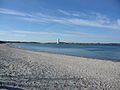
View from Dassower Strand in the NSG to Lübeck-Travemünde

Harkenbäk, estuary into the Baltic Sea (Barendorf)

View from the Stülper Huk to the Pötenitzer Wiek

Steep coast near Rosenhagen


City structure
Belong to the city of Dassow
- Center Dassow with Vorwerk and settlement
as well as the districts
|
|
Neighboring communities
Dassow is surrounded by the neighboring communities Kalkhorst in the northeast, Roggenstorf in the east, Stepenitztal in the southeast, Schönberg in the south, Selmsdorf in the southwest and Lübeck in the west.
history

Surname
From 1158 the landscape was called Darrsowe or Darxowe , in 1188 it was called Dartzchowe . In 1219 the place Dassow was first mentioned as Dartzowe ( old Polish name for place of thorns or bushes ). The spelling changed to Darsowe in 1415 and Dassow in the 15th century.
middle Ages
In the middle of the 12th century the Slavic castle was transformed into a German castle with a settlement, conveniently located on the road from Lübeck to Wismar . In defense of the Barbarossa privilege of 1188, the Lübeckers repeatedly came into conflict with the local nobility and the Mecklenburg dukes. In 1219 the Bishop of Ratzeburg waived his share of the bridge toll on the Dassower Bridge over the Stepenitz. The Duke, for his part, renounced the following year. In 1307 the Lübeckers decided with the Lauenburgers and the Holsteiners in peace at Herrenfähre to destroy the Dassow Castle. Still, no lasting peace returned. In 1505 the feud between the Hanseatic city of Lübeck and Mecklenburg and the Knights of Parkenthin in Dassow broke out in Lübeck .
The early Gothic Nikolaikirche was built as a granite block building in the second half of the 13th century. It is mentioned as early as 1230 in the Ratzeburg tithe register , which lists the localities that belonged to the diocese of Ratzeburg at that time , sorted according to parishes . The brick church tower dates from the 16th century.
The nearby Feldhusen castle wall dates from the 10th – 12th centuries. Century.
Modern times


Dassow belonged to Mecklenburg, with the third division of Mecklenburg in 1701 to Mecklenburg-Schwerin .
The most striking point is the reservoir built in the 18th century at the mouth of the Stepenitz . Here the goods from the area were stacked, which ships brought to nearby Lübeck.
Since the Middle Ages Dassow was associated with the lordship of Lütgenhof as a knightly spot ; the respective owner of Lütgenhof was both court lord and mayor of Dassow. In the 19th century, the constitution of the Fleckens and the regulation of the relationship between the inhabitants of the Fleckens Dassow and their landlord, the judiciary from Paepke on Lützenhof was a constant topic. In 1857, Grand Duke Friedrich Franz II issued a regulatory recession over the area and the Dassow field mark, and Paepcke gave the place its first basic and municipal code. On January 1, 1910, Dassow came to the Grand Ducal Domanium together with Vorwerk and Neuvorwerk . For this, the then owner of Lütgenhof Raimar von Paepcke received the Holm forest district from the Grand Duke and a payment of 150,000 marks. Dassow was granted town charter on April 1, 1938.
Dassow was occupied by US troops in early May 1945.
In May 1945 there was an explosion of discarded ammunition on the Holmer Feld near Spezenbruch near Dassow, which killed 28 German prisoners of war deployed there. They were buried in the local cemetery.
Dassow, the most north-westerly town of the GDR , was in the middle of the restricted area of the GDR border until the end of 1989 and could not be reached without special permits . The Dassower See, which belongs to Lübeck and thus to the territory of the Federal Republic of Germany, was separated from the city by the GDR border barriers and was not accessible from here. The near the Dassower lake at the transit route F 105 located Siechenhaus before Dassow was 1972/1973 eliminated from the boundary forces.
The city center and the old warehouse of Dassow have been completely renovated since 1991 as part of the urban development subsidy.
From 1952 to 1994 Dassow belonged to the Grevesmühlen district (until 1990 in the GDR district of Rostock , 1990–1994 in the state of Mecklenburg-Western Pomerania ). Since 1994 the city has been in the district of Northwest Mecklenburg .
From 1992 to 2005 Dassow was administered by the Baltic Sea Beach Authority. Since its dissolution, Dassow has belonged to the office of Schönberger Land.
Incorporations
Incorporation to Dassow took place in 1950 (Lütgenhof, Prieschendorf, Schwanbeck, Wilmstorf), 1957 (Wieschendorf), 1961 (Klein Voigtshagen) and 2004 (Harkensee, Pötenitz).
| Former parish | date | annotation |
|---|---|---|
| Barendorf near Dassow | 07/01/1950 | Incorporation to Harkensee |
| Benckendorf | 07/01/1961 | Incorporation to Pötenitz |
| Great Voigtshagen | 07/01/1950 02/01/1974 |
Incorporation to Roggenstorf, reclassification to Dassow |
| Harkensee | 06/13/2004 | |
| Klein Voigtshagen | 07/01/1961 | |
| Lütgenhof | 07/01/1950 | |
| Poetenitz | 06/13/2004 | |
| Prieschendorf | 07/01/1950 | |
| Rosenhagen | 07/01/1950 | Incorporation to Pötenitz |
| Schwanbeck | 07/01/1950 | |
| Tankenhagen | 07/01/1950 | Incorporation to Klein Voigtshagen |
| Volkstorf | 07/01/1950 | Incorporation to Benckendorf |
| Wieschendorf | 01/01/1957 | |
| Wilmstorf | 07/01/1950 |
Population development
|
|
Status: December 31 of the respective year
The strong increase in the number of inhabitants in 2005 is due to the incorporation of Harkensee and Pötenitz in 2004.
politics
City council
The city council of Dassow consists of 14 members and the mayor. The local election on May 26, 2019 resulted in the following composition of the city council with a turnout of 57.8%
| Party / list | Share of votes | Seats |
|---|---|---|
| SPD | 40.2% | 6th |
| Voting Community Ostseestrand | 31.5% | 4th |
| CDU | 19.9% | 3 |
| Alliance 90 / The Greens | 8.9% | 1 |
| total | 14th | |
mayor
- 1997-2004: Kerstin Weiss (SPD)
- 2004–2016: Jörg Ploen (SPD)
- since 2016: Annett Pahl (SPD)
Annett Pahl was elected on May 26, 2019 with 83.5% of the valid votes. She had been the representative of the sick mayor Jörg Ploen since 2016.
coat of arms
|
|
Blazon : "In silver on green ground a red castle with two pointed crenellated towers and an open gate, inside a green thorn bush."
The coat of arms was created by the Schwerin lithographer and painter Otto Menzel based on a proposal by the director of the Schwerin Secret and Main Archives, Dr. Friedrich Stuhr designed. It was awarded on October 28, 1927 by the Mecklenburg-Schwerin State Ministry and registered under the number 176 of the coat of arms of the state of Mecklenburg-Western Pomerania. |
| Reasons for the coat of arms: The coat of arms connects an urban symbol, a castle, with a speaking sign, a thorn bush as a reference to the Slavic place name (darč = thorn bush). According to popular tradition, the blocking of the gate by a thorn bush is said to have contributed to the fact that the place remained untouched by all innovations for centuries and kept a deep sleep. |
flag
The city does not have an officially approved flag .
Official seal
The official seal shows the city coat of arms with the inscription "STADT DASSOW • LANDKREIS NORDWESTMECKLENBURG".
Town twinning
Grobi Groa has been Dassow's twin town in Latvia since 2002 .

Attractions

- St. Nikolai Church , early Gothic brick church from the second half of the 13th century
- Tiger Park Dassow in the industrial area with white tigers , numerous other tiger species, alpacas and small animals
- Old port warehouse from 1861
- Retirement home with home parlor in Lübecker Straße 74, one of the oldest still standing half-timbered houses in Dassow
- Lütgenhof Castle , laid out as a mansion in 1839 and representative remodeled in 1890
- Johannstorf moated castle in Baroque style on the north bank of Dassower See (location of the award-winning film The White Ribbon )
- Pötenitz Castle , decaying former manor house and school building directly on the Bay of Lübeck within sight of Travemünde
- Harkensee Castle , renovated manor house, used as a country hotel
- Gravestones in the cemetery of the Evangelical Lutheran parish for six named Soviet and Polish victims of forced labor during the Second World War
- Memorial to the citizens of Dassow who fell in the First World War
- Coastal landscape nature reserve between Priwall and Barendorf with Harkenbäkniederung , includes the north bank of Dassower See , the east bank of Pötenitzer Wiek and the coastal landscape of Lübeck Bay in the city area. There on the border to the Priwall with its former water airport, on the east bank of the Pötenitzer Wiek, there is also the former pier and ruins of the Luftwaffenzeugamt See from the 1930s.
- Large stone grave Feldhusen
- Feldhusen castle wall , allegedly hiding the treasures of Klaus Störtebeker
Economy and Infrastructure
In addition to banks, medical practices, a pharmacy, kindergarten and school as well as some shops, Dassow has numerous other infrastructure facilities.
An extensive renovation program for the historic old town has been tackled. In addition, the development of tourism enjoys great attention.
More than 30 companies have settled in the Holmer Berg industrial park , including the Popcorn Company, two medical technology companies, Lübeck's Euroimmun and EndoComplete, the Hamburg-based pharmaceutical company AqVida and the component supplier, the GPE Group.
traffic
Dassow is on the federal highway 105 (Lübeck – Wismar). The Dassower Bridge leads over the Stepenitz. The state road 01 leads from Schönberg via Dassow to Klütz . The Bundesautobahn 20 (Lübeck– Rostock ) with the Schönberg junction is twelve kilometers south .
Schönberg (Meckl) train station is seven kilometers away on the Lübeck – Bad Kleinen line , from which a branch line led to Dassow until the late 1940s . Buses go to Grevesmühlen, Schönberg, Selmsdorf, Lübeck and via Klütz to Boltenhagen.
Personalities
sons and daughters of the town
- Johannes von Parkentin (before 1450–1511), Bishop of Ratzeburg
- Christian August von Berkentin (1694–1758), diplomat in the Danish service
- Johann Köhler (1751–1814) councilor in Lübeck
- Joachim Heinrich Voß (1764–1843), Prussian court gardener
- Friedrich Wigger (1825–1886), archivist
- Meno Rettich (1839–1918), politician ( German Conservative Party ), member of the Reichstag
- Wilhelm Beusch (1894–1979), prosecutor in the criminal proceedings against Adolf Seefeldt , Attorney General of Mecklenburg in 1944 , born in Groß Voigtshagen
- Ernst Puchmüller (1897–1976), baker, resistance fighter against National Socialism, director of the state institution for the blind
- Herbert Freitag (* 1915), politician ( CDU ), member of the state parliament
- Detlef Kletzin (* 1950), racing cyclist
- Lea Friedrich (* 2000), track cyclist
Other personalities related to the city
- Friedrich von Eyben (1699–1787), Chancellor of the royal Danish-Holstein government, lived in Dassow
- Carl Griewank (1795–1872), pastor in Dassow
- Axel Wilhelmi (1857–1928), doctor in Dassow
- Jens Voigt (* 1971), racing cyclist, grew up in Dassow
literature
- Carl Griewank : Brief description of the area around Dassow in Mecklenburg-Schwerin. Berlin 1846.
- 800 years of Dassow. A chronicle. Dassow 2019.
Web links
Individual evidence
- ↑ Statistisches Amt MV - population status of the districts, offices and municipalities 2019 (XLS file) (official population figures in the update of the 2011 census) ( help ).
- ^ Regional Spatial Development Program West Mecklenburg (2011) , Regional Planning Association, accessed on July 12, 2015
- ^ Main statute of the city of Dassow
- ↑ The constitution of the spot Dassow. Inventory overview of the State Main Archives Schwerin
- ↑ White flags over Dassow in Unser Mecklenburg 1965, No. 233. Source cited therein : DDR-Zeitung 1965. Quoted from: Joachim Schultz-Naumann: Mecklenburg 1945 . Universitas-Verlag, 2nd edition 1990. ISBN 3-8004-1215-2 . Pp. 283-284
- ↑ a b c municipalities 1994 and their changes since 01.01.1948 in the new federal states , Metzler-Poeschel publishing house, Stuttgart, 1995, ISBN 3-8246-0321-7 , publisher: Federal Statistical Office
- ^ StBA: Changes in the municipalities in Germany, see 2004
- ↑ Population development of the districts and municipalities in Mecklenburg-Western Pomerania (Statistical Report AI of the Statistical Office Mecklenburg-Western Pomerania)
- ^ Result of the local election on May 26, 2019
- ↑ Annett Pahl is running for mayor's office. In: Lübecker Nachrichten Online , April 26, 2019.
- ^ Result of the mayoral election on May 26, 2019
- ↑ Hans-Heinz Schütt: On shield and flag - the coats of arms and flags of the state of Mecklenburg-Western Pomerania and its municipalities . Ed .: production office TINUS; Schwerin. 2011, ISBN 978-3-9814380-0-0 , pp. 158/159 .
- ↑ a b main statute § 3 (PDF).
- ↑ Short biography , accessed on August 29, 2013
- ↑ Dassow's first major chronicle appears. In: Ostsee-Zeitung , September 3, 2019.

Alt Meteln | Bad little ones | Barnekov | Benz | Bernstorf | Bibow | Blowatz | Bobitz | Boiensdorf | Boltenhagen | Brüsewitz | Carlow | Cramonshagen | Dalberg-Wendelstorf | Damshagen | Dassow | Dechow | Mecklenburg village | Dragun | Gadebusch | Gägelow | Glasin | God's gift | Grambov | Grevesmühlen | Greaves | Large Molzahn | Big Stieten | Hohenkirchen | Tall beasts | Holdorf | Hornstorf | Poel Island | Jesendorf | Kalkhorst | Klein Trebbow | Klütz | Kneese | Koenigsfeld | Krembz | Krusenhagen | Lübberstorf | Luebow | Lübstorf | Lüdersdorf | Lützow | Menzendorf | Metelsdorf | Mills Eichsen | Neuburg | Neukloster | Passee | Perlin | Pingelshagen | Pokrent | Rehna | Rieps | Roduchelstorf | Roggendorf | Rye peat | Rögnitz | Rüting | Schildenal | Schlagsdorf | Schoenberg | Seehof | Selmsdorf | Siemz-Niendorf | Stepenitztal | Testorf-Steinfort | Thandorf | Upahl | Utecht | Veelböken | Ventschow | Warin | Warnow | Wedendorfersee | Wismar | Zickhusen | Zierow | Zurow | Züsow