
Gägelow
| coat of arms | Germany map | |
|---|---|---|

|
Coordinates: 53 ° 54 ' N , 11 ° 23' E |
|
| Basic data | ||
| State : | Mecklenburg-Western Pomerania | |
| County : | Northwest Mecklenburg | |
| Office : | Grevesmühlen-Land | |
| Height : | 30 m above sea level NHN | |
| Area : | 22.61 km 2 | |
| Residents: | 2610 (Dec. 31, 2019) | |
| Population density : | 115 inhabitants per km 2 | |
| Postal code : | 23968 | |
| Area code : | 03841 | |
| License plate : | NWM, GDB, GVM, WIS | |
| Community key : | 13 0 74 022 | |
| Office administration address: | Rathausplatz 1 23936 Grevesmühlen |
|
| Website : | ||
| Mayor : | Friedel Helms-Ferlemann (independent) | |
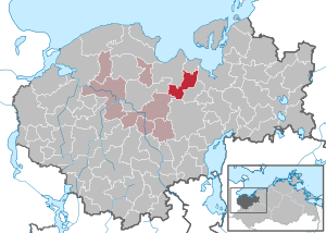
| Location of the community Gägelow in the district of Northwest Mecklenburg | ||
  |
||

Gägelow is a municipality in the district of Northwest Mecklenburg in Mecklenburg-Western Pomerania, Germany. The municipality has been administered by the Grevesmühlen-Land office since April 1, 2005, with its seat in the city of Grevesmühlen , which forms an administrative partnership with the office. The place is part of the Hamburg metropolitan region .
geography
Gägelow is located in slightly hilly terrain, sloping towards the Wismar Bay , directly on the southwestern city limits of the Hanseatic city of Wismar . The distance to the bathing beaches of the Eggers Wiek is only a few kilometers.
Gägelow is surrounded by the neighboring communities of Hohenkirchen and Zierow in the north, Wismar in the northeast, Barnekow in the east, Bobitz in the south, Upahl in the southwest and Grevesmühlen in the west.
The districts of Gressow , Jamel , Neu Weitendorf , Proseken , Sternkrug , Stofferstorf , Vosskuhl , Weitendorf and Wolde belong to Gägelow .
history
Gressow: The village church Gressow is a brick Gothic building from the 14th century, which was mentioned in 1230 in the Ratzeburg tithe register . Gutshaus Gressow dates from 1789. On July 1, 1950, Jamel and Wolde were incorporated into Gressow.
Jamel: was first mentioned in 1230 as Jamene and belonged to the parish of Gressow.
Neu Weitendorf: The large stone grave in the southeast is a megalithic complex of the funnel beaker culture, which dates from 3500 to 2800 BC. Was created.
Proseken: The Gothic village church Proseken was mentioned in 1230 in the Ratzeburg tithe register .
Weitendorf The Gothic chapel Weitendorf was listed in 1230 in the Ratzeburg tithe register. Landowners were u. a. the families Johann Flemming, von Manteuffel , von Plessen , von Fersen , von Negendanck (from around 1350), von Both (from 1764) and Biel (from 1784). On July 1, 1950, Weitendorf was incorporated into Gägelow.
politics
Community representation
The community council in Gägelow currently consists of 5 representatives of the SPD (the mayor as the chairman of the council with voting rights and 4 other representatives of the SPD), 4 representatives of the community of Gägelow, 2 members of the CDU and one member of the Die Linke party .
coat of arms
|
|
Blazon : “In blue a golden tip, covered with half a red tip, inside a twelve-petalled, golden rosette; a golden boulder in front and behind. "
The coat of arms was designed by the Weimar heraldist Michael Zapfe . It was approved on November 4, 1996 by the Ministry of the Interior and registered under the number 116 of the coat of arms of the state of Mecklenburg-Western Pomerania. |
| Justification of the coat of arms: In the coat of arms the tips and the rosette are supposed to symbolize the historically interesting village church in the district of Proseken, whose tower below the pointed helmet has rich decoration of diamonds, rosettes and pointed arches. The boulders are said to refer to the witnesses of the settlement in the Neolithic Age, to the numerous large stone graves in the communal corridor. The tinging indicates that the municipality belongs to the state of Mecklenburg. |
flag
The municipality does not have an officially approved flag .
Official seal
The official seal shows the municipal coat of arms with the inscription "GEMEINDE GÄGELOW • LANDKREIS NORDWESTMECKLENBURG".
Attractions

- Gressow village church
- Proseken village church
- Weitendorf Chapel
- Sculptures are exhibited on the Kunstweg to Weitendorf.
- Two graves in the cemetery in the district of Proseken for known Soviet forced laborers who were victims of forced labor in 1941/42. The memorial stone them applicable in 1991 by unknown assailants in a tomb beside it for three German Wehrmacht soldiers displaced
- The manor house in Gressow was built in 1789 at the behest of Friedrich II and served as the seat of the estate manager. It is now completely privately owned and is currently being renovated.
Economy and Infrastructure
It is noteworthy that a large number of companies have settled in the municipality's industrial areas. The basis for this lies not least in the good infrastructure of Gägelow at the gates of Wismar: the location on the federal highways 105 and 106 and on the connecting road from Wismar to the small town of Klütz . The federal motorway 20 runs south of Gägelow . The next train station is in Wismar .
Web links
Individual evidence
- ↑ Statistisches Amt MV - population status of the districts, offices and municipalities 2019 (XLS file) (official population figures in the update of the 2011 census) ( help ).
- ↑ https://www.destatis.de/GPStatistik/servlets/MCRFileNodeServlet/MVHeft_derivate_00002758/B731G_2014_01.pdf;jsessionid=0126F3A0CA13AB267FF21D5F2046A5B3&usg=AOWTuDgyg4zriKOK
- ↑ City council election 2019
- ↑ representation. Retrieved on February 26, 2019 (German).
- ↑ Hans-Heinz Schütt: On shield and flag - the coats of arms and flags of the state of Mecklenburg-Western Pomerania and its municipalities . Ed .: production office TINUS; Schwerin. 2011, ISBN 978-3-9814380-0-0 , pp. 162 .
- ↑ a b main statute § 1 (PDF).
- ^ Art Trail Weitendorf. Retrieved October 6, 2015 .

Alt Meteln | Bad little ones | Barnekov | Benz | Bernstorf | Bibow | Blowatz | Bobitz | Boiensdorf | Boltenhagen | Brüsewitz | Carlow | Cramonshagen | Dalberg-Wendelstorf | Damshagen | Dassow | Dechow | Mecklenburg village | Dragun | Gadebusch | Gägelow | Glasin | God's gift | Grambov | Grevesmühlen | Greaves | Large Molzahn | Big Stieten | Hohenkirchen | Tall beasts | Holdorf | Hornstorf | Poel Island | Jesendorf | Kalkhorst | Klein Trebbow | Klütz | Kneese | Koenigsfeld | Krembz | Krusenhagen | Lübberstorf | Luebow | Lübstorf | Lüdersdorf | Lützow | Menzendorf | Metelsdorf | Mills Eichsen | Neuburg | Neukloster | Passee | Perlin | Pingelshagen | Pokrent | Rehna | Rieps | Roduchelstorf | Roggendorf | Rye peat | Rögnitz | Rüting | Schildenal | Schlagsdorf | Schoenberg | Seehof | Selmsdorf | Siemz-Niendorf | Stepenitztal | Testorf-Steinfort | Thandorf | Upahl | Utecht | Veelböken | Ventschow | Warin | Warnow | Wedendorfersee | Wismar | Zickhusen | Zierow | Zurow | Züsow