Rye peat
| coat of arms | Germany map | |
|---|---|---|

|
Coordinates: 53 ° 55 ' N , 11 ° 4' E |
|
| Basic data | ||
| State : | Mecklenburg-Western Pomerania | |
| County : | Northwest Mecklenburg | |
| Office : | Grevesmühlen-Land | |
| Height : | 30 m above sea level NHN | |
| Area : | 19.88 km 2 | |
| Residents: | 457 (Dec. 31, 2019) | |
| Population density : | 23 inhabitants per km 2 | |
| Postal code : | 23936 | |
| Area code : | 038824 | |
| License plate : | NWM, GDB, GVM, WIS | |
| Community key : | 13 0 74 069 | |
| LOCODE : | DE RGT | |
| Office administration address: | Rathausplatz 1 23936 Grevesmühlen |
|
| Website : | ||
| Mayor : | Bernardus Straathof | |
| Location of the community Roggenstorf in the district of Northwest Mecklenburg | ||
Roggenstorf is a municipality in the northwest of the district of Northwest Mecklenburg in Mecklenburg-Western Pomerania (Germany). The municipality is administered by the Grevesmühlen-Land office with its seat in the city of Grevesmühlen , which forms an administrative community with the office. Agriculture plays a major role in Roggenstorf and the surrounding area. The proximity to the Baltic Sea is also interesting for tourists.
geography
The community of Roggenstorf stretches from the Klützer Winkel in the north to the Stepenitz valley . The steep coast of the Baltic Sea is about ten kilometers as the crow flies from Roggenstorf. The closest cities are Dassow , Klütz and Grevesmühlen.
Roggenstorf is surrounded by the neighboring communities of Kalkhorst in the north, Klütz in the northeast, Damshagen in the east, Stepenitztal in the south and Dassow in the west.
The districts of Alt-Greschendorf , Grevenstein , Rankendorf and Tramm belong to Roggenstorf .
history
On July 1, 1950, the previously independent municipalities Grevenstein and Groß Voigtshagen were incorporated.
Rankendorf: In 1220 the von Both family was named as the owner of Rankendorf, who owned the estate until 1764; then the von Bülow (18th century), von Müller (until 1890) and von Bobsien (until 1945) families. The two-storey, renovated mansion was built around 1870 in the neo-renaissance style. In the 1950s it was the central Hermann-Litzendorf-Schule , then until 1990 an old people's and nursing home was bought back by the Bobsien family.
coat of arms
|
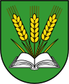
Blazon : "In green, growing out of an open silver book, three fan-shaped golden ears of rye with stalk leaves."
The coat of arms and the flag were designed by Jörg Mantzsch from Magdeburg . It was approved together with the flag on June 20, 2014 by the Ministry of the Interior and registered under number 354 of the coat of arms of the state of Mecklenburg-Western Pomerania. |
|
| Justification of the coat of arms: With the ears of rye, the coat of arms is based on the phonetics (not linguistically) of the place name, while the open book refers to the writer Fritz Reuter , who took the local pastor's daughter as his wife and stayed in the village for a while. |
flag
The flag is evenly striped lengthways in yellow and green. In the middle of the flag, spanning two-thirds of the yellow and two-thirds of the green stripes, is the municipal coat of arms, lined with yellow. The relation of the height of the flag cloth to the length is like 3: 5.
Official seal
The official seal shows the municipal coat of arms with the inscription "GEMEINDE ROGGENSTORF • LANDKREIS NORDWESTMECKLENBURG".
Attractions
The village church of Roggenstorf dates back to the 14th century; the important Low German writer Fritz Reuter and Luise Kuntze, the daughter of the Roggenstorf pastor , married here in 1851 . A plaque on the rectory of the church reminds of this.
In the Rankendorf district there is a former manor house, which has now been renovated, and old agricultural tools can be viewed in a guest house. The speck tower in Rankendorf , built from field stones in 1856, seems a bit strange; it was a building that originally served all residents of Rankendorf for smoking . Outwardly it is reminiscent of a medieval village church, the nave of which was divided into apartments. A mineralogical collection is displayed in the windmill built in 1903 in the Grevenstein district. Instead of the cap, it has an observation tower. In the near future, a boulder garden will be built in a former gravel pit .
traffic
The federal road 105 leads from Wismar to Lübeck through the south of the municipality (district Tramm) . The restricted area to the Federal Republic of Germany began in Tramm during the GDR era - almost 20 km before the Selmsdorf / Lübeck-Schlutup border crossing at that time . The Schönberg driveway on the A 20 is approx. 15 km away, the nearest train station is in Grieben ( Lübeck – Bad Kleinen railway line ).
Individual evidence
- ↑ Statistisches Amt MV - population status of the districts, offices and municipalities 2019 (XLS file) (official population figures in the update of the 2011 census) ( help ).
- ↑ a b main statute § 1 (PDF).


