Zurow
| coat of arms | Germany map | |
|---|---|---|

|
Coordinates: 53 ° 51 ' N , 11 ° 38' E |
|
| Basic data | ||
| State : | Mecklenburg-Western Pomerania | |
| County : | Northwest Mecklenburg | |
| Office : | Neukloster-Warin | |
| Height : | 48 m above sea level NHN | |
| Area : | 40.68 km 2 | |
| Residents: | 1304 (Dec. 31, 2019) | |
| Population density : | 32 inhabitants per km 2 | |
| Postal code : | 23992 | |
| Area code : | 038422 | |
| License plate : | NWM, GDB, GVM, WIS | |
| Community key : | 13 0 74 090 | |
| Office administration address: | Hauptstrasse 27 23992 Neukloster |
|
| Website : | ||
| Mayor : | Eckhardt Stelbrink | |
| Location of the municipality Zurow in the district of Northwest Mecklenburg | ||
Zurow is a municipality in the east of the district of Northwest Mecklenburg in Mecklenburg-Western Pomerania (Germany). The municipality, located southeast of the Hanseatic city of Wismar , is administered by the Neukloster-Warin office , based in the city of Neukloster .
geography
The municipality of Zurows is located in the transition area from the hill country east of the Wismar Bay to the extreme northwest of the Sternberg Lake District . The community, surrounded by three small lakes, is around eleven kilometers from the Hanseatic city of Wismar .
Districts
The districts belong to Zurow
- Drive
- Kahlenberg
- Little Warin
- Krasov
- Nakenstorf
- Reinstorf
- Schmakentin
history
Zurow was a Slavic village and then a medieval church village . The name goes back to the Slavic word zurowy , the name for a type of blueberry. The Gothic village church dates from the end of the 14th century. The individual property was first mentioned in 1303.
Until it was expropriated without compensation on the basis of the ordinance on land reform of September 5, 1945, the knightly estate Zurow was owned for 20 years by the printing company owner and publisher Wilhelm Girardet , who from 1924 to 1945 undertook a series of measures to fundamentally modernize the company and its facilities Had initiated an increase in performance (melioration, power supply, afforestation Schmiedeberg, water pipeline from Weissensee to supply the manor house and village, sewer system, establishment of modern workshops). In 1945 around 70 settlers were allocated and transferred partial areas of less than 10 hectares per settlement area. From 1952 the settlers (some only under massive pressure) contributed their land to the newly founded LPG "Progress". This was later merged with four other production cooperatives and businesses in the neighborhood and finally comprised 5,000 hectares of usable space, initially with a focus on plant and animal production. As part of the ordered specialization, animal production was outsourced. Extensive stables for industrially oriented factory farming (200 dairy cows, 2 × 5,000 pigs / year) were built. This branch of the economy collapsed soon after German unification and the stables fell into disrepair.
During the GDR era, there was a holiday camp in Nakenstorf with bungalow buildings in which French children could also relax.
Incorporations
On July 1, 1950, the previously independent community of Ravensruh was incorporated. Klein Warin was incorporated into Reinstorf on January 1, 1957. The community of Reinstorf lost its independence on July 1, 1961 and was incorporated into Zurow. Krassow joined on January 1, 2002.
Attractions
Buildings
- Gothic village church Zurow made of brick from the end of the 14th century with the approximately 900-year-old linden tree. The bell, cast in 1462, has rare, art-historically significant carved bell drawings that are honored in a work by the art historian Ingrid Schulze.
- Neo-Baroque , nine-axis manor house as a two-storey plastered building from 1837 with a gabled central risalit , crooked hip roof and ridge turret with curved bell dome ; today holiday home. The estate was first mentioned in 1303.
- Thatched three-sided courtyard in Reinstorf
Kirchlinde Zurow
The old church linden tree stands in the churchyard of the historic brick church of the town, which is still used as a cemetery today. As a natural monument designated and in the prominent list and old tree specimens registered Sommerlinde one of the oldest trees in Germany; their age is given there as 900 years. It is believed that it will be planted in 1345, the year the church was built.
The mighty trunk of the tree veteran was broken apart in a thunderstorm around 1800; a large part of the crown was lost. The linden tree has recovered from it and healed itself through overgrowth. The remaining trunk had a circumference of 9 m when measured in 2011. With its newly formed crown, the tree has now reached a height of 15 meters again.
politics
coat of arms
|
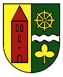
Blazon : “Split; in front in gold a floating, pointed red church tower with three (2: 1) pointed arched windows, a hatch and a closed pointed arched door; at the back a silver wave thread in green, accompanied: on top by a golden wheel with eight spokes protruding over the rim, on the bottom by a golden clover leaf. "
The coat of arms and the flag were designed by the Schwerin heraldist Heinz Kippnick . It was approved together with the flag on December 16, 2002 by the Ministry of the Interior and registered under No. 271 of the coat of arms of the state of Mecklenburg-Western Pomerania. |
|
| Reasons for the coat of arms: In the coat of arms, the church tower refers to the Zurower Church, a single-nave brick building, the nave of which was built in the late 14th century. The richly decorated tower dates from the 15th century. The wave thread is supposed to indicate the small bodies of water in the vicinity, the wheel and the cloverleaf are supposed to symbolize the traditional main occupation of the inhabitants, agriculture, especially agricultural technology, arable farming and the Cattle farming. |
flag
The flag is uniformly striped in green and yellow across the longitudinal axis of the flag cloth. In the middle of the flag, spanning a third of the length of the green and yellow stripes, is the municipal coat of arms. The length of the flag is related to the height as 5: 3.
Official seal
The official seal shows the municipal coat of arms with the inscription "GEMEINDE ZUROW • LANDKREIS NORDWESTMECKLENBURG".
Economy and Infrastructure
After the closure of the connected secondary and secondary school, and later also the primary school, Zurow still has a day-care center today. Two farms cultivate the area in the area. Furthermore, there is a civil engineering company and a building material processing facility in Zurow, a cider factory in the Reinstorf district and a carpentry in the Klein Warin district. An industrial park was built on federal highway 192 . In Zurow there is also a tire service, a vintage car and agricultural machinery dealer and a nail salon as well as a cosmetic studio, a daycare center, a doctor, a consumer and a hairdresser. An emergency telephone is also available. Zurow also has its own bus stop.
The districts of Klein Warin and Nakenstorf are located in the area of the Neuklostersee and the Großer Wariner See in the Sternberger Seenland nature park . In addition to the riding stables in Klein Warin, the tourist offers also include guest houses and hotels.
Transport links
Due to its location on the federal motorway 20 with a direct junction, Zurow is connected to the national road network. Zurow is the starting point of the federal highway 192 to Neubrandenburg . The next train stations are in Hornstorf and Wismar .
Sons and daughters of the place
- Wilhelm Uhthoff (1853–1927), ophthalmologist
- Walter Lehmbecker (1898–1980), senior teacher, local researcher and writer
Web links
Individual evidence
- ↑ Statistisches Amt MV - population status of the districts, offices and municipalities 2019 (XLS file) (official population figures in the update of the 2011 census) ( help ).
- ^ Mario Riemann, Rural life in Mecklenburg in the first half of the 20th century, Verlag Ingo Koch, Rostock 2004, ISBN 3-937179-17-8 , S / 271-284
- ↑ a b Municipalities 1994 and their changes since 01.01.1948 in the new federal states , Metzler-Poeschel publishing house, Stuttgart 1995, ISBN 3-8246-0321-7 , publisher: Federal Statistical Office
- ↑ StBA: Changes in the municipalities in Germany, see 2002
- ^ Ingrid Schulze: Incised drawings by lay hands - drawings by medieval sculptors and painters? Figural bell scratch drawings from the late 13th century to around 1500 in central and northern Germany. Leipzig 2006, ISBN 978-3-939404-95-8
- ^ Bruno Sobotka: Castles, palaces, manor houses in Mecklenburg-Western Pomerania . Konrad Theiss Verlag, 1993.
- ↑ Germany map THE OLDEST TREES. Retrieved May 13, 2020 .
- ↑ Mecksikon sends its regards. Retrieved May 13, 2020 .
- ↑ Friedhofslinde in Zurow. Retrieved May 13, 2020 .
- ↑ Hans-Heinz Schütt: On shield and flag - the coats of arms and flags of the state of Mecklenburg-Western Pomerania and its municipalities . Ed .: production office TINUS; Schwerin. 2011, ISBN 978-3-9814380-0-0 , pp. 184/185 .
- ↑ a b main statute § 1 (PDF).


