
Stoffelskuppe
| Stoffelskuppe
(Stopfelskuppe)
|
||
|---|---|---|
 Perched on a stubble field south of the Stoffelskuppe |
||
| height | 620.1 m above sea level NHN | |
| location | near Roßdorf ; District of Schmalkalden-Meiningen , Thuringia ( Germany ) | |
| Mountains | Salzunger Werrabergland or Vordere Rhön | |
| Dominance | 2 km → Pless | |
| Notch height | 100 m | |
| Coordinates | 50 ° 43 '39 " N , 10 ° 13' 5" E | |
|
||
| Type | extinct volcano | |
| rock | Basalt breakthrough in red sandstone | |

The Stoffelskuppe or Stopfelskuppe is 620.1 m above sea level. NHN high mountain in the Vorderer Rhön or in the Salzunger Werrabergland . It is located near Roßdorf in the Thuringian district of Schmalkalden-Meiningen ( Germany ).
geography
location
The Stoffelskuppe rises in the northeast of the Rhön biosphere reserve and - with its summit region - in the municipality of Roßdorf to the south (Schmalkalden-Meiningen district); The municipality of Dermbach (Wartburgkreis) extends up to about 550 m height of the western slope . The village of Roßdorf is 2.9 km south of the summit and the Dermbacher district of Bernshausen 1.65 km west. At the Roßdorfer Tor ( 526.6 m ) to the north-north-east , the Dermbacher municipality boundary meets that of the municipalities of Breitungen in the east-northeast and Rosa (both district of Schmalkalden-Meiningen) in the southeast. The municipality of Bad Salzungen (Wartburg district) spreads out slightly northwest of the Roßdorfer Tor .
On the lower part of the western slope of the mountain lies the Erdfallsee Bernshäuser Kutte . The north-eastern neighboring mountain is the Pleß 2.4 km away ( 645.4 m ).
Natural allocation
The Stoffelskuppe is widely regarded as one of the northeastern mountains of the Anterior Rhön . Geographically it counted the Federal Institute for Regional Studies already for Salzunger Werra Bergland , the Thuringian State Institute for Environment and Geology , however, still the (front) Rhon. Genetically, the summit is clearly a mountain of the Rhön volcanism, but lies in the middle of the red sandstone of the Werrabergland.
According to the Federal Institute for Regional Studies, the Stoffelskuppe belongs to the natural spatial main unit group Osthessisches Bergland (No. 35) and in the main unit Salzunger Werrabergland (359) to the subunit Stadtlengsfelder Hügelland (359.0).
geology
The morphologically hard basalt stone of the Stoffelskuppe has saved softer layers of red sandstone from being eroded. Its basalt dome was preserved as a remnant of an earlier basalt ceiling. Its southern slope is taken up by a naturally formed basalt rubble dump, which also partially covers the sandstone existing underground.
Nature and protected areas
|
Stoffelskuppe
|
|
| location | Thuringia , Germany |
| surface | 22.9 ha |
| WDPA ID | 165752 |
| Geographical location | 50 ° 44 ' N , 10 ° 13' E |
| Setup date | 1961 |
The species-rich dry and rubble forests of the Stoffelskuppe are no longer used for forestry purposes and have developed into primeval forest-like stands. The rock heaps of the mountain are the habitat of rare lichens, deciduous mosses and animal species and are significant from the point of view of species protection. Characteristic of the dumps is the wooly jagged cap moss ( Racomitrium lanuginosum ), which can be recognized by its long glass hair , which is classified as very rare in Germany. Little shrews ( Sorex minutus ) often climb over the blocks .
On the summit region and high position parts of the southern slope of the Stoffel tip which is protected area Stoffel tip ( CDDA -No 165752;. Expelled 1961 22.68 ha large). Parts of the Thuringian Rhön landscape protection area ( CDDA no. 20897; designated 1989; 631.8923 km²), the fauna-flora-habitat area Pleß-Stoffelskuppe-Bernshäuser Kutte (FFH- EU no. 5227-301 ; TH -Nr. 87; 15.7 km² ; in the European nature reserve system Natura 2000 ) and the bird sanctuary Thuringian Rhön (VSG-Nr. 5326-401; 199.49 km²).
hike
Various hiking trails and paths lead to the Stoffelskuppe. The 175 km long Hochrhöner hiking trail runs over the east and south slopes . The 8.8 km long Rhön-Rundweg Urnshausen 3 leads over the eastern slope, around the mountain, to the nearby Schönsee , through Bernshausen and past the Bernshausen Kutte . Starting points for hikes are, for example, the villages of Bernshausen, Roßdorf, Rosa and Urnshausen on the mountain. With good visibility conditions, the summit region offers a view of mountains and valleys in the north of the Rhön.
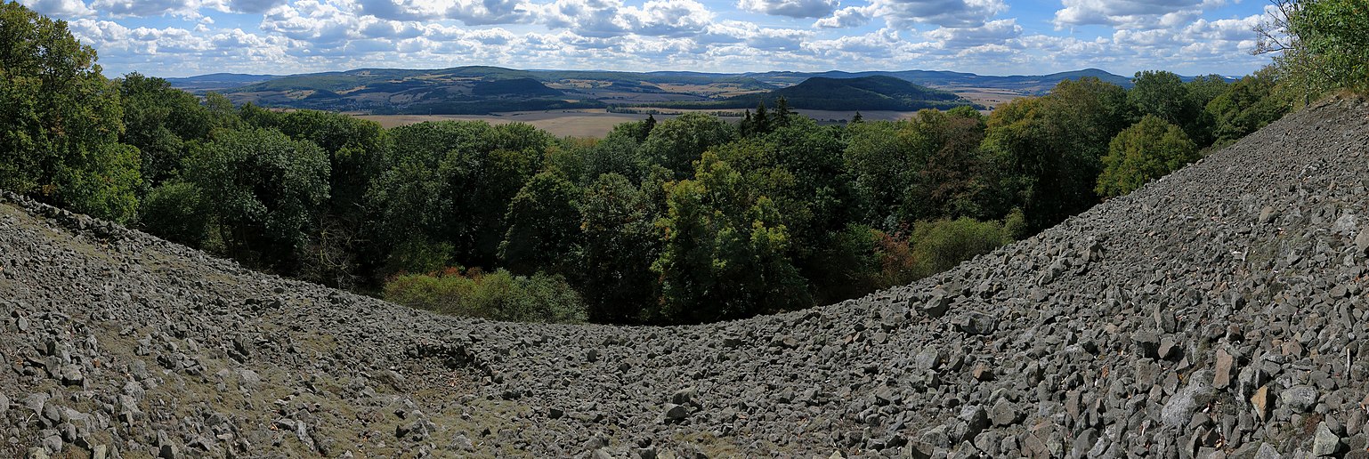
View over the dump into the Rhön

See also
Web links
Individual evidence
- ↑ a b c Map services of the Federal Agency for Nature Conservation ( information )
- ↑ a b Werner Röll: Geographical land survey: The natural space units on sheet 126 Fulda. Federal Institute for Regional Studies, Bad Godesberg 1969. → Online map (PDF; 4.2 MB)

Arnstein | Bischofswaldung with Stedtlinger Moor | Broad Lakes | Eichelberg | Forstloch - Riedwiesen | Ganswiese | Large deer hide meadow | Hembachwald | Hofberg | Horbel - Hoflar - Birkenberg | Horn with bald head | Monastery forest | Long Rhön | Nesselgrundwiese | Oberhofer Schloßberg | Rhönkopf - Streufelsberg | Rhönwald | Schützenbergmoor | Schwarzbacher Grund | Seimbergswald | Spitzberg | Still | Stoffelskuppe | West slope of Dolmar | Ten-book