
Thimphu (District)
| Thimphu District | |
|---|---|
  |
|
| Basic data | |
| Country | Bhutan |
| Capital | Thimpu |
| surface | 2067 km² |
| Residents | 138,736 (2017) |
| density | 67 inhabitants per km² |
| ISO 3166-2 | BT-15 |
Coordinates: 27 ° 30 ' N , 89 ° 36' E
Thimphu ( ཐིམ་ ཕུ་ རྫོང་ ཁག་ ), formerly Chirang , is one of the 20 dzongkhag (districts) of Bhutan . It has an area of 2067 km² with 138,736 inhabitants (2017). The main town is the eponymous capital of Bhutan, Thimphu .
Thimphu is in turn divided into 8 Gewogs :
- Chang Weighed
- Dagala Weighed
- Geney Weighed
- Kawang Weighed
- Lingzhi Weighed
- Mewang Weighed
- Naro Weighed
- Soe Weighed
gallery
- Thimphu District
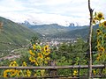
View of the city of Thimphu

Rice terraces

Farmhouse

Expansion of the road to Dochu La

108 choirs on the Dochu La

View from Dochu La


Web links
Commons : Thimphu District - Collection of images, videos and audio files

Bumthang | Chukha | Dagana | Gasa | Haa | Lhuntse | Mongar | Paro | Pemagatshel | Punakha | Samdrup Jongkhar | Velvet | Sarpang | Thimphu | Trashigang | Trashiyangtse | Trongsa | Tsirang | Wangdue Phodrang | Zhemgang