
Thurnhof (municipality of Perg)
|
Thurnhof ( village ) locality |
|||
|---|---|---|---|
|
|||
| Basic data | |||
| Pole. District , state | Perg (PE), Upper Austria | ||
| Judicial district | Perg | ||
| Pole. local community | Perg ( KG Pergkirchen) | ||
| Coordinates | 48 ° 14 '45 " N , 14 ° 39' 31" E | ||
| height | 265 m above sea level A. | ||
| Residents of the village | 258 (January 1, 2020) | ||
| Building status | 58 (2001) | ||
| Post Code | 4320 | ||
| prefix | + 43/07262 | ||
| Statistical identification | |||
| Locality code | 10188 | ||
| Counting district / district | Pergkirchen (41 116 003) | ||
| Source: STAT : index of places ; BEV : GEONAM ; DORIS | |||

Thurnhof is a village with 204 and 216 inhabitants (2001 and 2011 census) in the cadastral municipality of Pergkirchen in the municipality of Perg in the Perg district in Upper Austria .
geography
The village derives its name from a derelict moated castle , the remains of which belong to the building stock of the Thurn farmers.
Thurnhof is located on the Thurnhofbach, which is called Lamplbach in the upper reaches, and drains into the Naarn via the Naarn and Tobrabach canals .
The settlement borders in the west on the village of Kickenau in the cadastral community Perg and is surrounded in the northwest, north, east and south by localities of the cadastral community Pergkirchen , with the village Karlingberg in the north-west, the village Mitterberg in the north and the Pergkirchen and bordered to the south by the village of Auhof .
From a geological and geomorphological point of view, as well as in terms of the use of space, the village is located in the two spatial units, Upper Austrian spatial units, southern Mühlviertler Randlagen and Machland
The Mitterberg castle ruins are only a few hundred meters north of the village. Mitterberg was the seat of the Machland district court until 1485.
population
In the historical local lexicon, 9 houses are mentioned in 1788 and 8 houses in 1809. In 1825 there were 50 inhabitants in 12 houses and in 1869 in 12 houses there were 81 inhabitants. In the second half of the 20th century the number of houses increased from 22 in 1951 to 58 in 2001, with 24 in 1961, 29 in 1971, 31 in 1981, 34 in 1991 and 58 in 2001. The number of inhabitants increased from 1951 and 1961 with 113 to 115 in 1971, 108 in 1981 and 1991 and 204 in 2001 and in 2007 and 216 in 2011.
The village had only a few houses until the 20th century. Only in the second half of the 20th century were single and two-family houses built for families in newly created settlements, which led to a considerable increase in the population.
Thurnhof moated castle
The Thurnhof moated castle was a noble residence . The largely preserved residential tower is a special feature. The preserved buildings such as the residential tower and stables were used for agriculture until recently. They all belong to the modern Thurnbauer homestead, Thurnhof N ° 1.
Picture gallery Wasserburg Thurnhof
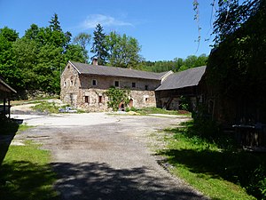
main building

Right stables

main building

Back of the main building


traffic
The village of Thurnhof was crossed by Hauderer-Straße from the beginning of the 16th century and was on Donau Straße B3 until the beginning of the 21st century . After the completion of the Perg bypass, this section of the route was taken over into the municipal road network of the city of Perg.
literature
- Norbert Grabherr : Castles and palaces in Upper Austria. Oberösterreichischer Landesverlag, 2nd edition, Linz 1970, p. 265 (Thurnhof).
- Leopold Josef Mayböck , Leopold Pötscher: Heimatbuch der Stadt Perg. Hrsg. Heimatverein Perg, Stadt Perg. Denkmayr Druck, Linz 2009, ISBN 978-3-902598-90-5 , p. 187 ( Der Thurnhof ).
Web links
Individual evidence
- ^ Kurt Klein (edit.): Historical local dictionary . Statistical documentation on population and settlement history. Ed .: Vienna Institute of Demography [VID] d. Austrian Academy of Sciences . Upper Austria Part 2, Perg and Pergkirchen ( online document , explanations . Suppl . ; both PDF - oD [actual.]).

Cadastral municipalities: Perg | Pergkirchen | Weinzierl
Locations: Aisthofen | Auhof | Dörfl | Karlingberg | Kickenau | Lanzenberg | Lehenbrunn | Mitterberg | Perg | Pergkirchen | Thurnhof | Tobra | Weinzierl | Zeitling
Districts:
Karlingberg ·
Perg ·
Weinzierl ·
Zeitling |
Villages:
Aisthofen ·
Auhof ·
Lanzenberg ·
Pergkirchen ·
Tobra |
Rotten:
Lehenbrunn ·
Pasching / Karlingberg-Lehenbrunn ·
Thurnhof |
Scattered houses:
Dörfl ·
Kickenau |
Settlements:
Poschachersiedlung ·
Mitterberg |
Other locations:
Auhof Castle ·
Forndorf [-Lehenbrunn]
Counting district: Perg city center | Perg-city-surroundings-north | Weinzierl | Pergkirchen | Perg-city-surroundings-south