
Tongatapu
| Tongatapu | ||
|---|---|---|
 |
||
| Waters | Pacific Ocean | |
| Geographical location | 21 ° 13 ′ S , 175 ° 9 ′ W | |
|
||
| length | 34.2 km | |
| width | 17.8 km | |
| surface | 260.48 km² | |
| Highest elevation | Zion Hill (Chapel Hill) 65 m |
|
| Residents | 74,685 (2016) 287 inhabitants / km² |
|
| main place | Nuku'alofa | |
 |
||

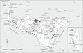
Tongatapu is the largest and with almost 74,700 inhabitants (as of 2016) also the most populous island in the Kingdom of Tonga . At the 2006 census, 23,658 people lived in Nukuʻalofa , the largest city of Tongatapu and the capital of Tonga, and 34,311 in the agglomeration . The island can be reached via the international airport Fuaʻamotu and the port in Nukuʻalofa. The island also gives its name to the surrounding archipelago and administrative unit.
Geography and nature
The island is 257.03 km² in size (260.48 km² with secondary islands ) and fairly flat, as it is made up of coral limestone . It is covered with a thick, fertile layer of soil that has been fertilized with volcanic ash by the neighboring volcanoes . While the steep coast in the south can be up to 35 m high, the island in the north sinks towards the sea level. The highest natural elevation on Tongatapu is 65 m high. It is located in the very south of the island between the villages of Fuaʻamotu and Nakolo.
To the north of the island there are isolated small islands and many coral reefs that can reach up to 7 km from the shore into the sea. In the north are the Fanga'uta and Fangakakau lagoons , which are almost completely closed by reefs , with a water depth of between 1 and 6 m. The entire lagoon system of 2,835 hectares was placed under nature protection in 1974. The mangrove forests , consisting mainly of mangrove trees of the red mangrove ( Rhizophora sp.), Are an important breeding area for fish and birds.
Archipelago
The islands of the archipelago of the same name include, in addition to many small motu, the islands of Minerva (Ongo Teleki, Nicholson's Shoal), Tongatapu, ʻAta and ʻEua .
history
People of the Lapita culture
The earliest traces of the settlement of Tongatapu by people of the Lapita culture can be traced back to 900–850 BC. To date. The archaeologist David Burley found pottery shards in the Fanga'uta lagoon, the place of manufacture of which was 2000 km away from the Santa Cruz Islands from the Solomon Islands .
Tongan Empire
Tongatapu was always the seat of the capital of the Tongan Empire , but in a sea area that is up to 1000 km away, this was often only a symbolic rule. Little is known of the first capital, Toloa , around 1000 years ago in the area of today's Fuaʻamotu airport.
Also from the second capital Niutoua ( Heketa ) on the coast in the northeast of the island essentially only a stone archway ( Haʻamonga ʻA Maui ) made of three cuboid coral blocks with a total weight of about 120 tons remains. It is interpreted as the entrance to a missing royal palace. Notches that point to the rising sun on the shortest day of the year, as well as the course of the paths leading from the gate to the coast, could indicate an astronomical function of the gate.
Only the third capital from around 1220 to 1851 in today's city of Mu'a can offer several traditional sights. There are more than 28 royal burial mounds (dating from around the 12th century) to see, from simple earthworks to rectangular, terraced stone structures made of coral blocks. These graves may not be explored any further.
Early contacts with Europeans
The first European on the island was Abel Tasman in 1643, who traded goods on Tongatapu and the neighboring islands of ʻAta and ʻEua . Another visitor was James Cook on his third South Seas voyage; he was received and entertained in a festive manner and observed a solar eclipse there on July 5, 1777 .
cards

Historical map of Tongatapu (1924)


Web links
Individual evidence
- ^ Tonga Tonga National Population and Housing Census 2016. Statistics Department Tonga, 2016, accessed April 9, 2018 .
- ↑ United Nations Development Program Government of Tonga and United Nations Development Program. UNDP, 2014. Retrieved September 7, 2017.
Niua Group : Niuafoʻou | Niuatoputapu | Tafahi
Vavaʻu group : Fonualei | Late | Toku | Vava'u
Ha'apai group : Fatumanongi | Foa | Fotuhaʻa | Ha'ano | Hakauata | Kao | Lifuka | Limu | Lofanga | Luahoko | Luangahu | Meama | Niniva | Nomuka | Nukupule | Ofolanga | Tofua | 'Uiha | Uoleva | Uonukuhahake
Tongatapu Group: ʻAta | ʻEua | Tongatapu
Disputed Area: Minerva Reefs