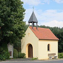
Untersteinbach (Hirschau)
|
Untersteinbach
City of Hirschau
Coordinates: 49 ° 36 ′ 8 " N , 11 ° 58 ′ 49" E
|
|
|---|---|
| Height : | 439 m above sea level NN |
| Residents : | 23 (1997) |
| Postal code : | 92242 |
| Area code : | 09608 |
|
Location of Untersteinbach in Hirschau
|
|
Untersteinbach has been part of the town of Hirschau in the district of Amberg-Sulzbach in the Upper Palatinate in Bavaria since 1978 ; before that, Untersteinbach was part of the community of Massenricht, which was incorporated at the same time .
geography
Natural allocation
Untersteinbach is located in the north of the Upper Palatinate hill country . Since sheet 154/155 Bayreuth of the single sheets 1: 200,000 for the manual of the natural spatial structure of Germany has not been published, there is no detailed breakdown for the northern part of the Upper Palatinate hill country .
In relevant specialist literature, the geological subunit in which Rödlas is located is referred to as the Kohlberger ridges .
history
Untersteinbach was listed in the tax bill of the Hirschau nursing office from 1577.
On May 1, 1978, Untersteinbach was incorporated into the town of Hirschau as part of the municipality of Massenricht, together with the places Massenricht, Obersteinbach , the hamlets of Rödlas and Träglhof and the desert Hummelmühle as part of the municipal reform.
Religions
The religious confusion of the 16th and 17th centuries also had an impact in the area around Untersteinbach. It can be assumed that Untersteinbach, which has always belonged to the Benefice and later to the Ehenfeld branch , changed denominations several times. In 1628 Untersteinbach became finally Catholic together with Ehenfeld.
Ehenfeld is still independent as a parish , but has formed a pastoral care unit with Hirschau since 2003 .
Architectural monuments
See: List of architectural monuments in Hirschau # Untersteinbach
Economy and Infrastructure
traffic
Untersteinbach can be reached from Hirschau via Ehenfeld , Massenricht and Obersteinbach after ten kilometers via the district road AS 18 or after three kilometers via side streets from Kohlberg . Untersteinbach is on the border between the Amberg-Sulzbach district and the Neustadt an der Waldnaab district .
Untersteinbach is connected to local public transport with two bus routes. This is the RBO line 59 via Lintach to Amberg ( VGN line 459). This line was extended on September 1, 2001 to Untersteinbach. Previously it was the end of the line in Massenricht. The second line is the local line service Hirschau, which connects the districts of Hirschau with each other (RBO line 6334, VGN line 468).
The nearest train stations are in Freihung (7 km), in Röthenbach (3 km) and in Amberg (27 km).
education
The children from Untersteinbach went to school in Röthenbach until mid-November 1946 . On November 20, 1946, when an emergency school was set up in the Prösl inn in Massenricht, the children from Untersteinbach went to school in Massenricht. On October 17, 1949, the school in Massenricht was inaugurated. Teaching continued there until the school was closed in 1976. Today, students from Untersteinbach go to primary school in Ehenfeld and secondary school in Hirschau .
Web links
- Homepage of the village of Massenricht and its districts
- massenricht.de> Districts> Untersteinbach> Pictures. In: massenricht.de. Oberpfälzer Waldverein Zweigverein Massenricht eV, accessed on June 29, 2015 .
- Alois Laumer: Obersteinbach, Röthenbach, Roethenbach, aerial photo Oberpfalz Untersteinbach. In: www.oberpfalz-luftbild.de. Retrieved on October 23, 2012 (aerial photos from Untersteinbach).
- Untersteinbach. In: hirschau.de. City of Hirschau, accessed on November 17, 2012 .
Individual evidence
- ↑ Untersteinbach ( page no longer available , search in web archives ) Info: The link was automatically marked as defective. Please check the link according to the instructions and then remove this notice. - Website of the city of Hirschau
- ↑ Districts - city of Hirschau, district of Amberg-Sulzbach (AS) - Bavarian authorities guide. In: behoerdenwegweiser.bayern.de. Bavarian State Ministry of the Interior , accessed on November 27, 2012 .
- ^ Dietrich Jürgen Manske: Geographical land survey: The natural space units on sheet 164 Regensburg. Federal Institute for Regional Studies, Bad Godesberg 1981, pp. 53–54. → Online map (PDF; 4.8 MB)
- ^ Stefan Glaser, Gertrud Keim, Georg Loth, Andreas Veit, Barbara Bessler-Veit, Ulrich Lagally: Geotopes in the Upper Palatinate . Ed .: Bavarian State Office for the Environment. 1st edition. 2007, ISBN 978-3-940009-92-0 , pp. 47 .
- ↑ Dr. Dietrich-Jürgen Manske: The Amberg Sulzbach district in the mirror of the times . S. 9–46 ( heimatforschung-regensburg.de [PDF]).
- ^ Commemorative publication of the Massenricht volunteer fire brigade for the 125th anniversary of the founding party, Massenricht, 2009, p. 45 ff
- ^ Commemorative publication of the Massenricht volunteer fire brigade for the 125th anniversary of the founding party, Massenricht 2009, p. 47
- ↑ Verkehrsgemeinschaft Amberg-Sulzbach (line 459 - VGN) ( Memento of the original from June 20, 2013 in the Internet Archive ) Info: The archive link was inserted automatically and has not yet been checked. Please check the original and archive link according to the instructions and then remove this notice. (PDF; 22 kB) on znas.de
- ^ Commemorative publication of the Massenricht volunteer fire brigade for the 125th anniversary of the founding party, Massenricht, 2009, p. 49
- ↑ Verkehrsgemeinschaft Amberg-Sulzbach (line 468 - VGN) ( Memento of the original from June 20, 2013 in the Internet Archive ) Info: The archive link was inserted automatically and has not yet been checked. Please check the original and archive link according to the instructions and then remove this notice. (PDF; 14 kB) on znas.de
- ↑ http://www.xn--khlersiedlung-imb.info/anton_meindl_chronik.pdf
- ^ Commemorative publication of the Massenricht volunteer fire brigade for the 125th anniversary of the founding party, Massenricht 2009, p. 55 ff.


