Yunlin County
|
Yunlin County 雲林 縣 |
|||
 Top left to bottom right: Shiluo Bridge and the Zhuoshui River, Chaotian Temple in Beigang, Xinqi Memorial Hall in Douliu, Caoling Village in Gukeng, Erlun History Museum, Dounan Railway Station |
|||
|
|||
| State : |
|
||
| Founded : | 1950 | ||
| Coordinates : | 23 ° 42 ′ N , 120 ° 30 ′ E | ||
| Area : | 1,290.8 km² | ||
| Residents : | 689.003 (April 2018) | ||
| Population density : | 534 inhabitants per km² | ||
| Time zone : | UTC + 8 (Chungyuan time) | ||
| Telephone code : | (+886) (0) 5 | ||
| Postal code : | 630-638, 640, 643, 646-649, 651-655 | ||
| ISO 3166-2 : | TW-YUN | ||
| District capital : | Douliu | ||
| Structure : | 1 city (市) 5 municipalities (鎮) 14 rural municipalities (鄉) |
||
| District Administrator: | Su Chih-fen ( 蘇治芬 ) | ||
| Website : | |||
| Circle bird: | Formosan blue magpie | ||
| Circle flower: | Phalaenopsis | ||
| Circle tree: | Camphor tree | ||

|
|||
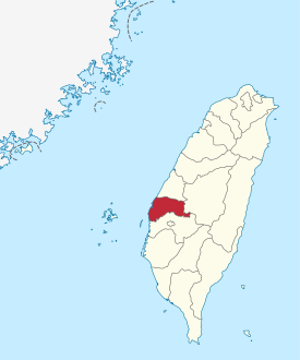
The Yunlin County ( Chinese 雲林縣 / 云林县 , pinyin Yunlin Xiàn , Tongyong Pinyin Yunlin Sian , W.-G. Yun-lin Hsien , PEH OE jī Hun Lim koan ) is a district of the Republic of China on Taiwan . Located in the central part of western Taiwan, its capital is Douliu . Well-known in Taiwan are its agricultural products such as grapefruit , tea , suan cai (a pickled Chinese cabbage ), papaya and sugar melon .
geography
Yunlin County is located at the transition from the Jianan Plain in the south to the Changhua Plain in the north, which together form the largest plain in Taiwan. In the north, the Zhuoshui , Taiwan's longest river, and its lower reaches form the border with Changhua County . Yunlin County borders on Chiayi County to the south, Nantou County to the east, and Formosa Road to the west .
The district consists of 90% plains, along the eastern border there are a few hills and in the southeast it extends into the northwestern foothills of the Alishan Mountains .
history
The Yulin area was originally inhabited by the Pingpu , Austronesian peoples of the plains . After Taiwan was taken over by the Chinese Empire after 1683, during the reign of Kangxi , Han Chinese immigrants from the mainland increasingly flocked to the island. The indigenous population was gradually assimilated or pushed eastwards. Initially, Taiwan was divided into three counties, with Yunlin belonging to Zhuluo County. In 1761, during the reign of Qianlong , an inspection was set up in Douliu to cover Yunlin. In 1887, Taiwan became a separate Chinese province and Yunlin was given county status. After Taiwan had to be ceded to Japan after the Sino-Japanese War of 1895 , the district was dissolved again. Several administrative reorganizations took place under the Japanese rule and from 1926 Yunlin belonged to Tainan Prefecture . After Taiwan was transferred to the Republic of China after World War II, there was another reorganization and in 1950 Yunlin County was re-established.
cities and communes
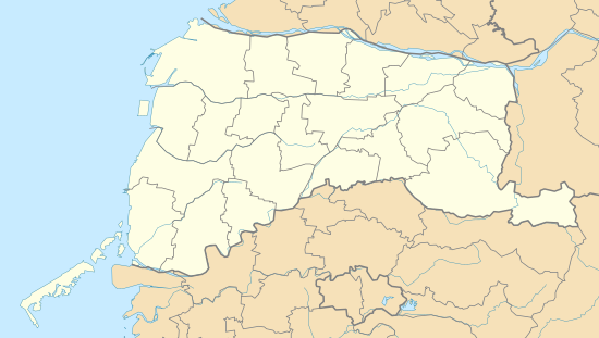
The capital Douliu, with a population of 108,590 (as of May 2018), is the only city ( 市 , Shì ) in the district. There are also five urban parishes ( 鎮 , Zhèn ) and 14 rural parishes ( 鄉 , Xiāng ). According to the official statistics from April 2018, the population figures and area data for the municipalities were as follows:
| local community | chin. | Hanyu Pinyin | Taiwanese (POJ) | Hakka | Area (km²) |
Residents | Ew./km² |
|---|---|---|---|---|---|---|---|
| 1 city | |||||||
| Douliu | 斗六市 | Dǒuliù Shì | Tau-la̍k-chhī | Téu-liuk | 93.7151 | 108,590 | 1,160 |
| 5 municipalities | |||||||
| Addition | 北港 鎮 | Běigǎng Zhèn | Pak-káng-tìn | Pet-kóng | 41.4999 | 40,130 | 967 |
| Dounan | 斗南 鎮 | Dòunán Zhèn | Tau-lâm-tìn | Téu-nàm | 48.1505 | 44,796 | 931 |
| Huwei | 虎尾 鎮 | Hǔwěi Zhèn | Hó͘-bóe-tìn | Fú-mî | 68.7420 | 70,858 | 1,031 |
| Tuku | 土庫 鎮 | Tǔkù Zhèn | Thô͘-khò͘-tìn | Thú-khù | 49.0212 | 28,837 | 589 |
| Xiluo | 西螺 鎮 | Xīluó Zhen | Sai-lê-tìn | Silo | 49.7985 | 46.129 | 927 |
| 14 rural parishes | |||||||
| Baozhong | 褒忠 鄉 | Bāozhōng Xiāng | Po-tiong-hiong | Pô-chûng | 37.0552 | 13,035 | 350 |
| Citong | 莿桐 鄉 | Cìtóng Xiāng | Chhì-tông-hiong | Tshṳ̀-thùng | 50.8502 | 28,806 | 567 |
| Dapi | 大埤 鄉 | Dàpí Xiāng | Toā-pi-hiong | Thai-phî | 44,9973 | 19,140 | 426 |
| Dongshi | 東 勢 鄉 | Dōngshì Xiāng | Tang-sì-hiong | Tûng-sṳ | 48.3562 | 14,942 | 308 |
| Erlun | 二 崙 鄉 | Èrlún Xiāng | Jī-lūn-hiong | Ngi-lûn | 59.5625 | 27.102 | 456 |
| Gukeng | 古坑 鄉 | Gǔkēng Xiāng | Kó͘-kheⁿ-hiong | Kú-hâng | 166,6059 | 31,589 | 190 |
| Kouhu | 口 湖鄉 | Kǒuhú Xiāng | Kháu-ô͘-hiong | Khiéu-fù | 80.4612 | 27,524 | 342 |
| Linnei | 林 內 鄉 | Línnèi Xiāng | Nâ-lāi-hiong | Lìm-nui | 37.6035 | 18,259 | 483 |
| Lunbei | 崙 背 鄉 | Lúnbèi Xiāng | Lūn-poè-hiong | Lûn-poi | 58.4840 | 24,563 | 421 |
| Mailiao | 麥 寮 鄉 | Màiliáo Xiāng | Be̍h-liâu-hiong | Ma̍k-liàu | 80.1668 | 45,638 | 569 |
| Shuilin | 水 林 鄉 | Shuǐlín Xiāng | Chu-n-hiong | Súi-lìm | 72.9582 | 25,563 | 350 |
| Sihu | 四 湖鄉 | Sìhú Xiāng | Sì-ô͘-hiong | Si-fù | 77.1189 | 23,464 | 305 |
| Taixi | 臺 西鄉 | Táixī Xiāng | Tâi-se-hiong | Thòi-sî | 54.0983 | 23,952 | 441 |
| Yuanchang | 元 長 鄉 | Yuánzhǎng Xiāng | Goân-chióng-hiong | Ngièn-tshòng | 71.5872 | 25,864 | 361 |
| Yunlin County parishes |
Universities
- Yunlin National University of Science and Technology
- National University of Formosa (1997-2004 renamed: National Institute of Technology Huwei )
- University of Chinese Medicine (Department in Beigang)
- Transworld Institute for Technology
Culture
Web links
- Yunlin County Official Site (English Version)
Individual evidence
- ↑ Historical Evolution. Yunlin County website, accessed August 28, 2018 .
- ↑ 各 月 人口 資料 (括弧 內 為 資料 起始 年月) 03 鄉鎮 戶數 及 人口 數 (9701) ("Population data for each month (in brackets is the starting month of the data) 03 municipalities and population (9701)"). Taiwan Ministry of the Interior, accessed May 11, 2018 (Chinese).


