
Cologne green belt
The Cologne green belt are planned scale green zones , focusing on both banks of the Rhine in a semicircle around the city of Cologne set. They emerged from the former fortress paleons of the Cologne fortress ring.
prehistory
Even in the Middle Ages, the city of Cologne did not tolerate any development around the city walls , in particular no castles or permanent houses (fortified houses). This was all the more necessary with the advent of cannons and the reinforcement of the city walls with bastions and bulwarks . With the transition of the French-occupied Rhineland to Prussia after the Congress of Vienna in 1815, the military administration built Cologne from 1816 to 1846 (on the left bank of the Rhine) and from 1818 to 1863 (around Deutz ) into a fortress town. In front of the bulwarks, 14 forts and nine smaller lunettes were placed at a distance of 480 to 560 meters , but these were replaced after the Franco-Prussian War by an outer fortress ring with eleven forts and countless intermediate structures, which were placed around the suburbs from 1873 to 1881. Nevertheless, the inner fortress ring remained intact until the end of the First World War . According to the provisions of the Treaty of Versailles , all fortifications had to be razed.
Planting the green belt
According to the will of the English occupation, the fortifications should remain as wasteland. The Mayor of Cologne at the time, Konrad Adenauer , managed to ensure that not all of the facilities had to be demolished after they had been softened and that the area could be converted into parks according to a general development plan by the Hamburg city planner Fritz Schumacher , also to avoid land speculation. From 1922, after overcoming resistance from the landowners to be expropriated, the construction of green areas and sports facilities could begin. The work was carried out as a job creation measure during the period of high unemployment after the First World War . The inner fortress ring in Deutz can only be reconstructed on the course of the streets. The innermost rayon around Cologne's medieval walls was built on as early as 1881 from the abandoned medieval city walls and the modern bastions, which were designed into ring roads, to the railway line with Cologne Neustadt , after the city had given the Prussian treasury this 120 hectare part of the Had bought the fortress belt by a council resolution of May 23, 1880 for 11,794,000 marks. The Cologne rings had already been partially loosened up by green spaces. Smaller parking spaces were already integrated into the Neustadt. In the largest park in the southern part of the city, the Volksgarten , the garden architect Adolf Kowallek had already integrated Lunette 3 and Fort IV as structures.
Inner green belt
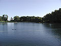
The ring around Cologne could not be completely closed. The inner green belt stretches about seven kilometers from the Rhine near Cologne-Riehl to Luxemburger Strasse (until the 1960s only as far as Zülpicher Strasse). The parks around Fort IV in the Volksgarten , which Adolf Kowallek laid out between 1887 and 1889, are separated by the railway line to Cologne's southern bridge and do not stand out as belonging to the green belt. The railway line that turns from Luxemburger Straße to Bonn makes the interruption even clearer. Only on the banks of the Rhine can a piece of green belt be seen again with the peace park around Fort I with preserved fortress terraces as a flower garden. Its counterpart is the rose garden around Fort X on Neusser Wall. In between there are large park and meadow areas and the four-hectare Aachener Weiher on Aachener Straße . The university was also able to expand here in 1929/1934. Especially at the university and the Aachener Weiher, the geometrical forms of the paths and facilities that dominated at the time can still be seen today. The inner green belt is bounded towards the city center by the ring-shaped railway line around the Neustadt and towards the suburbs by the Innere Kanalstrasse / Universitätsstrasse. The installation took place essentially between 1922 and 1924.

Fort Paul in the Volksgarten

Volksgartenweiher

Building of the WiSo Faculty University of Cologne Wilhelm Riphahn
Aachener Weiher, view Uni-Center (Cologne)

Summer pavilion, Aachener Weiher

"Alhambra" Cologne trinkets
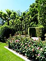
Rose garden of the city of Cologne in Fort X
Street sign in memory of Carola Williams

Public tennis court between Subbelrather and Venloer Straße


A section of the inner green belt is a small park, the so-called “Alhambra”, located between Merheimer Platz and Escher Strasse, which opens onto Innere Kanalstrasse , in the Cologne-Nippes district . The centerpiece of this strictly symmetrical complex is a “sunken garden” (sunken perennial garden) with a fountain in the center, probably based on Karl Foerster's (1874–1970) ideas. This central fountain and a small wall fountain at the north end of the park have been dry for years. A ball playground forms the western area of the facility. The two heads of the small complex have older trees, benches are beneath the trees on the south side, and a children's playground is on the north side.
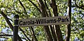
Since May 6, 2018, the part of the green belt between Aachener and Vogelsanger Strasse has been called Carola-Williams-Park . The Williams building stood here from 1947 to 1955 .
Green areas of the inner fortress ring on the right bank of the Rhine
The outdoor area of the older fortifications on the right bank of the Rhine could only be used in two places for larger green spaces, especially that of the northern Fort XI on the Rhine, whose area forms part of the Rheinpark . A lunette near the Deutz Jewish cemetery provided space for the Deutz city garden.
Outer green belt


.JPG)

.jpg)


The outer green belt extends beyond what was then Cologne's urban area. So land from the communities in the surrounding area also had to be bought or expropriated for compensation. According to a city guide from 1927, 200 hectares of green spaces with “sports and playgrounds, school gardens, forest schools, air baths and flower gardens” were to be created. Since the opening ceremony on September 16, 1923, the green belt extends over an area of around 800 hectares, 400 hectares of which are forest, all with accompanying footpaths and cycle paths. The military ring runs through the entire Outer Green Belt; Small parcels, allotments and cemeteries face the city. On the other side of the road there is a strip of forest interspersed with sports areas and the former fortifications, which in turn are adjoined by open meadows and embedded water areas: Kalscheurer Weiher, Decksteiner Weiher and Adenauerweiher; their excavation was heaped up to form mounds. A newly planted forest belt with fast-growing foreign tree species completes the belt; it forms a protection zone to the overpowering lignite and chemical industry in the adjoining foothills and weakens the emissions of the A 4 and A 1 motorways . The landscape park in the sector between Aachener Strasse and Bonner Strasse is particularly well developed . It is also used the most by the population of Cologne and the surrounding area. A large sports center with a stadium and numerous other sports facilities was built on both sides of Aachener Strasse as part of the green belt .
In 2010, with the support of sponsoring companies, the Cologne forest administration created an experimental field for forest development in climate change between the forest accompanying the Decksteiner Weiher and the motorway : the forest laboratory . It joins the forest botanical garden and the arboretum in the Cologne city forest , both of which are also located in the outer green belt. The developed area can be reached from the parking lot at Haus am See and from the Stüttgenhof stop . Guided tours are offered.
Leisure time and gastronomy
You can punt on the Decksteiner Weiher and the Kalscheurer Weiher. With the approval of the city, the association "Unser Kalscheurer Weiher eV", which arose from a citizens' initiative, lends the boats and operates a stall. The association has taken over the barges and pedal boats from the fore leaseholder and restored them, and under special conditions, rebuilt a little booth with toilet facilities in the landscape conservation area that had been demolished by the city. A mini golf course is laid out at the Decksteiner Weiher next to the house on the lake. There and at the other end of the pond, in the club house of 1. FC Köln , there is an upscale gastronomic offer. At the Adenauerweiher this is even exceeded by the Club Astoria , which was built in 1948 for Belgian occupation officers; after their withdrawal and corresponding modifications, the club reopened in September 2007.
Development
The Cologne Green Foundation 2014, the designation and award over a 65 km long circular path in the outer green belt, the part with the roughly twice as long Cologne path is identical, and launched with the support of sponsors a free hiking map.
Green belt on the right bank of the Rhine
The fortress line on the right bank of the Rhine ran more in a north-south direction between the railway lines, which also bypassed the residential buildings, and the suburbs. The green corridor with cemeteries, allotments, sports facilities and park areas, which is not so clearly visible here, also runs. The most important facility in the green belt on the right bank of the Rhine is the Merheimer Heide .
Radial connections
The 105 hectare Cologne city forest was laid out in the area of the Kitschburg estate in Cologne-Lindenthal as early as 1896 . The Blücherpark between Nippes and Neuehrenfeld was built between 1910 and 1913. The Fritz-Encke-Volkspark from 1922/1926 and the Vorgebirgspark from 1911 to 1913 lie between Zollstock and Raderberg and connect the green belt with the Volksgarten in the south green corridor. The 70 hectare Müngersdorfer sports facilities with the Jahnwiesen were built in 1921. These open spaces between the streets radially stretching from Cologne to the surrounding area, on which the suburb urban development also took place, could be kept free and developed as an approach for green and fresh air to the city center . This is particularly clear in the connection between the outer green belt, urban forest expansion with arboretum , urban forest and the walking paths along the Lindenthal Canal along the Rautenstrauchstrasse and Clarenbachstrasse to the Aachen pond of the inner green belt.

Clarenbach Canal

Rautenstrauchkanal

Rautenstrauchkanal

Perennial gardens in Fritz-Encke-Park
Konrad Adenauer (chairman of the HUG Cologne) on the origin and importance of the radial connections of the Cologne green belt


Changes after World War II
Immediately after the end of the Second World War, some open spaces in the inner green belt had to be used as debris dumping areas for part of the rubble of 30 million m³ from Cologne, which was more than 80 percent destroyed (for example in the inner green belt of Herkulesberg , but also at conveniently accessible points in the Outer green belt, for example on the Vorgebirgsbahn before Efferen). In some peripheral areas, the inner green belt was then also built on (with high-rise buildings and the Colonius television tower , but also with the natural sciences buildings as an extension of the university campus ). The East Asian Museum with a small Japanese garden built on the Aachen pond is a special gem .
outlook

The idea of Adenauer and Schumacher is constantly being developed as far as possible. The Rhineland Nature Park beyond the Ville can be seen as Cologne's third green belt . Together with the planning authorities of the surrounding area, the radial connections of the green belts will then also be extended to the nature park.
Cologne Green Foundation
Committed to the work of their grandfather, Konrad Adenauer's grandchildren , building contractors Paul Bauwens-Adenauer and Patrick Adenauer , founded the Kölner Grün Foundation in 2004 , which was presented to the for the first time on November 17, 2006 with an inventory and a catalog of needs for action then Lord Mayor Fritz Schramma , went public. The foundation, under Beatrice Bülter as executive board member, hopes to be able to counteract the sometimes desolate state of Cologne's historic green system through further civic and municipal commitment, patrons and sponsorship of the industry. The foundation's board of trustees includes other well-known Cologne personalities.
In the summer of 2007, the Cologne Green Foundation started the community foundation campaign “1000 Benches for Cologne” to equip the inner and outer green belts and their radial connections and Cologne green spaces with more benches and waste bins, which are made by a workshop for the disabled . The donors can have a brass plaque with an individual text attached to the benches and largely determine the location themselves. In the meantime, more than one million euros have been donated by private individuals and companies for benches in the green. "1000 Trees for Cologne" is now the name of another project that can be donated through the Street Tree Foundation. Brass plates can also be attached there. There are numerous projects that have been carried out in cooperation with the foundation on individual sections of the entire Cologne green system. For example, RWE Power (formerly Rheinbraun ), which has its administration in the green belt on Dürener Straße, could be won over for a donation to restore the arboretum bordering the outer city forest , other companies supported the renovation of the pavilion in the rose garden of the city of Cologne in 2013 . Analogous to the master plan for Cologne from 2008 by the architect Albert Speer junior , whose initiators also included Paul Bauwens-Adenauer, a general plan for the renovation was drawn up in cooperation with the city, Speer, landscape architects and the citizens of this city under the project name Grüngürtel: Impuls 2012 of the entire green system. This plan was adopted by the Cologne City Council in 2013. Lord Mayor Jürgen Roters signed a joint charter with the founders of the foundation.
Belvedere Landscape Park
The Belvedere landscape park was created as the latest project as part of the further development of the Cologne greenery. It is located in the outer area between Müngersdorf and Bocklemünd . It was opened to the public in 2014 and has since completed the Outer Cologne Green Belt and is part of one of the corridors that connect it to the Rhineland Nature Park .
Extension of the Eifelwall

Red: Planning area for the new building of the Historical Archive of the City of Cologne
The inner green belt is to be expanded by converting an industrial wasteland in the Sülz district of Cologne , bounded in the west by Luxemburger Strasse, in the north by Eifelwall, in the south by Hans-Karl-Nipperdey-Strasse and in the east by a railway body. In the northern part of the industrial wasteland, the new building of the historical archive of the city of Cologne is planned. The initially decided location for the art and museum library was abandoned in July 2013 for cost reasons. After completion of the archive building, the green area will be created.
literature
- Henriette Meynen: The Cologne Green Plants - The Urban and Garden Architectural Development of Urban Green and Fritz Schumacher's Green System , Contributions to Architectural and Art Monuments in the Rhineland, Volume 25, with a separate 24-page hinged map section, Schwann Düsseldorf 1979, ISBN 3-590- 29025-0 .
- Dorothea Wiktorin, Jürgen Blenck, Josef Nipper (Hrsg.): Cologne, the historical-topographical atlas. Emons, Cologne 2001, ISBN 3-89705-229-6 .
- Kölner Grün Stiftung (Ed.): Green Belt Impulse Cologne: Basis for Completing a Vision , Greves, Cologne 2013, ISBN 978-3-7743-0620-2 .
- A green area with history. Fortifications and outer green belt in Cologne . Festschrift for Konrad Adenauer. Edited by Fortis Colonia. Cologne 2015. ISBN 978-3-9817714-1-1 .
media
- Rheinhard Zeese: 1900 years of fortified Cologne , CD, LEB - Brühl, 2006
- Rheinhard Zeese: Historical parks and public gardens in Cologne 1801 to 1932 , CD, LEB - Brühl, 2007
Web links
- Brief description of the circular route with the option of downloading descriptions of the individual stages (at: ich-geh-wandern.de)
- Outer green belt
- Cologne Green Foundation
- Green axis south, Volksgarten to Hofgarten, Bonn (bike path)
- Website of the citizens' initiative Kalscheurer Weiher
- koelner-festungsbauten.de
Individual evidence
- ^ Carola-Williams-Park: New name for the park at the Aachener Weiher. In: Radio Cologne. May 3, 2018, accessed May 7, 2018 .
- ↑ Little Guide through Cologne, ed. from the traffic office of the city of Cologne, 1927, (on the international press exhibition Köln Pressa 1928), p. 83
- ↑ Cologne Forest Laboratory
- ↑ club page
- ↑ Kölner Stadt-Anzeiger from 1./2. September 2007
- ↑ Bauwens history - bauwens.de. In: www.bauwens.de. Retrieved September 30, 2016 .
- ↑ Article in the Kölner Stadtanzeiger from July 2008 reproduced in Grünstiftung Projekte Festkomitee + Arboretum (accessed September 1, 2008)
- ↑ see web link below ( Memento of the original dated May 31, 2012 in the Internet Archive ) Info: The archive link was inserted automatically and has not yet been checked. Please check the original and archive link according to the instructions and then remove this notice.
- ^ Resolution in the Cologne City Council of July 18, 2013
- ↑ Press release from the City of Cologne / urban development synergon on the participation process and open space planning competition Masterplan Inner Green Belt + Extension Eifelwall, Cologne - “MaIn Green Belt” from September 2012