
Ōi (river)
| Ōi | ||
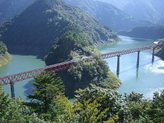
 Bridge of the Tōkaidō main line over the Ōi |
||
| Data | ||
| location | Japan | |
| River system | Ōi | |
| source | at Aino-dake 35 ° 38 ′ 33 ″ N , 138 ° 13 ′ 18 ″ E |
|
| Source height | approx. 2600 m TP | |
| muzzle |
Suruga Bay Coordinates: 34 ° 45 ′ 54 " N , 138 ° 17 ′ 29" E 34 ° 45 ′ 54 " N , 138 ° 17 ′ 29" E |
|
| Mouth height | 0 m TP | |
| Height difference | approx. 2600 m | |
| Bottom slope | approx. 15 ‰ | |
| length | 168 km | |
| Catchment area | 1280 km² | |
| Drain |
MQ |
30.9 m³ / s |
| Left tributaries | Ōjiro, Sasama | |
| Right tributaries | Akaishizawa, Sakai, Sumata | |
| Reservoirs flowed through | Tashiro Reservoir, Hatanagi Reservoir, Ikawa Reservoir, Nagashima Reservoir | |
| Big cities | Shizuoka ( Aoi-ku ) | |
| Medium-sized cities | Shimada , Yaizu , Yoshida | |
| Small towns | Kawanehon | |
The Ōi ( Japanese 大 井 川 , Ōi-gawa ) is a 168 km long river on the Japanese island of Honshū . It rises in the Akaishi Mountains , flows through the central part of Shizuoka Prefecture and flows into Suruga Bay . It drains an area with a size of 1280 km². Outstanding features are its enormous gradient and high amounts of sediment . 15 dams dam the Ōi and its tributaries.
description
The source is located at an altitude of more than 2600 m TP on the southern slope of the Aino-dake , with 3189 m the second highest point of the Akaishi Mountains and the fourth highest mountain in Japan. The borders with the prefectures of Nagano and Yamanashi run along the nearby mountain ridges . In the source region, the annual rainfall is more than 3000 mm. As a steeply sloping mountain stream, the mehrerei flows several dozen kilometers through the completely uninhabited northern part of the Aoi-ku district of the prefecture capital Shizuoka .
The Ōi takes many small tributaries and there are four reservoirs along the course of the river, each several kilometers long. These are the Tashiro Reservoir ( 1380 m TP ), the Hatanagi Lake ( 935 m TP ), the Ikawa Lake ( 635 m TP ) and the Nagashima Reservoir ( 435 m TP ). In the area of the said lakes and below it meanders , the flow very heavily to numerous towering hills and ledges around, wherein it further comprises an above-average gradient. Only in the middle section, in the area of the Kawanehon municipality , are there settlements on the riverbank. In the urban area of Shimada , the river valley widens considerably, to form an alluvial cone with side arms several hundred meters wide . The Ōi flows into Suruga Bay on the southwestern edge of the Shida plain .
Over the millennia, the position of the river bed in the Shida plain and thus the position of the mouth changed several times. Seen from today's center of Shimada , the Ōi once flowed eastwards towards Yaizu . As a result, the estuary shifted, so that the river gradually made a bend to the southeast and the estuary is closer to Yoshida today .
history

Records from the Nara period mention the Ōi as the border between the provinces of Suruga and Tōtōmi . During the Edo period , the Tōkaidō developed into an important traffic route between the cities of Edo (now Tokyo ) and Kyoto . The daimyōs from the western fiefs had to travel to Edo once a year as part of the Sankin kōtai to be present at the court of the Shōgun . However, the Tokugawa shogunate forbade the construction of bridges over major rivers for safety reasons. In the case of the Ōi, even ferries were not allowed. Contemporary woodblock prints ( ukiyo-e ) show that travelers had to cross the river either on horseback or litters carried on shoulders. In bad weather or floods, they often had to spend several days or even weeks in the nearest post offices of Shimada-juku and Kanaya-juku .
A well-known poem aptly describes the difficulty of crossing the river: 箱根 八里 は 馬 で も 越 す が 越 す に 越 さ れ ぬ 大 井 川 , Hakone hachiri wa uma demo kosu ga, kosu ni kosarenu Ōigawa (“Even horses can cope with the eight ri of Hakone To cross Ōi is difficult in any case. ")
At the beginning of the Meiji period , which heralded the rapid modernization of Japan, there was no longer any reason to hold on to the bridge-building ban. Several bridges were built within a few years, which made traffic much easier. A well-known example is the Hōrai Bridge , built in 1879 , the longest wooden pedestrian bridge in the world.
Dams and hydropower plants
The Ōi and several of its tributaries are dammed by a total of 15 dams . Of these, 13 are used to generate electrical energy using hydropower . One dam is used to dam a drinking water reservoir , another is used for flood protection .
At the beginning of the 20th century, the government recognized the hydroelectric potential. The Ōi is characterized by a large amount of water and a fast current. The mountainous upper reaches and its tributaries lie in largely uninhabited valleys with high rainfall. The Anglo-Japanese Hydroelectric Company ( 日 英 水力 電 気 , Nichiei Suiroku Denki ) built the first small hydroelectric power station in 1911 . However, the Kiso and Tenryū rivers attracted more investors and the company did not flourish for the time being. It was renamed Hayakawa Denryoku ( 早川 電力 ) in 1921 and planned to direct water from Ōi through a system of pressure tunnels to Hayakawa in Yamanashi Prefecture to generate electricity . Work on the Tashiro Dam lasted from 1924 to 1928. One year after construction began, the Hayakawa Denryoku was taken over by the predecessor of today's Tepco and was temporarily called Ōigawa Denki ( 大 井 川 電 気 ).
Further construction work was delayed by the global economic crisis and came to a complete standstill after the outbreak of the Pacific War . After the end of the war, the US occupying power ordered the reprivatisation of the electricity industry, which had meanwhile been nationalized. The newly founded Chūbu Denryoku took over all systems and discontinued projects on Ōi, with the exception of the Tashiro Dam. With the help of foreign loans, Chūbu Denryoku began an ambitious expansion program in the early 1950s that lasted more than two decades. The company took on a pioneering role in the development of gravity dams .

| flow | investment | Reservoir | construction time | Height (m) | Power (MW) | operator | location |
|---|---|---|---|---|---|---|---|
| Ōi | Tashiro dam | Tashiro reservoir | 1924-1928 | 17.3 | 39.5 | Tepco | Coord. |
| Ōi | Hatanagi-I dam | Hatanagi Lake | 1957-1961 | 125.0 | 86.0 | Chūbu Denryoku | Coord. |
| Ōi | Hatanagi II dam | - | 1957-1961 | 69.0 | 85.2 | Chūbu Denryoku | Coord. |
| Ōi | Ikawa dam | Ikawa lake | 1952-1957 | 103.6 | 62.0 | Chūbu Denryoku | Coord. |
| Ōi | Okuizumi Dam | - | 1952-1956 | 44.5 | 87.0 | Chūbu Denryoku | Coord. |
| Ōi | Nagashima Dam | Nagashima Reservoir | 1972-2002 | 109.0 | (1) | MLIT | Coord. |
| Ōi | Ōigawa Dam | - | 1934-1936 | 33.5 | 68.2 | Chūbu Denryoku | Coord. |
| Ōi | Shiogō dam | - | 1958-1961 | 58.0 | 3.2 | Chūbu Denryoku | Coord. |
| Akaishizawa | Akaishi Dam | Akaishi reservoir | 1983-1990 | 58.0 | ? | Chūbu Denryoku | Coord. |
| Ōjiro | Ōjiro dam | - | 1968 | 43.0 | (2) | Shizuoka Prefecture | Coord. |
| Sakai | Sakaigawa Dam | - | 1939-1943 | 34.2 | ? | Chūbu Denryoku | Coord. |
| Sasama | Sasamagawa Dam | - | 1955-1960 | 46.4 | 58.0 | Chūbu Denryoku | Coord. |
| Sumata | Ōma dam | Ōma reservoir | 1936-1938 | 46.1 | ? | Chūbu Denryoku | Coord. |
| Sumata | Senzu dam | - | 1930-1935 | 64.0 | 22.2 | Chūbu Denryoku | Coord. |
| Sumata | Sumatagawa Dam | - | 1934-1936 | 34.8 | ? | Chūbu Denryoku | Coord. |
(1) Drinking water storage tank, no electricity generation
(2) Flood protection dam
traffic
Only on the last 15 kilometers of the lower reaches is the area characterized by urban areas. In this area, the Ōi is bridged by several important traffic routes on long viaducts. These are prefecture roads 31, 34, 150 and 381, the Tōmei highway , the prefecture route 34, the Tōkaidō Shinkansen , the Tōkaidō main line , the national road 1 and the Shin-Tōmei highway . All other bridges are only of local importance. Kawanehon Township, located in the middle of the river, is accessible via National Roads 362 and 473. Other roads on the upper reaches serve as feeders to the dams.
The railway company Ōigawa Tetsudō operates two railway lines along the river. They were originally built to facilitate the construction of the dams; today they mainly serve the tourist excursion traffic. The Ōigawa main line connects Kanaya with Senzu , the Ikawa line continues from there to Ikawa .
photos

Hatanagi Reservoir

Ikawa dam
Nagashima reservoir with railway bridge

Nagashima Dam

Hōrai Bridge

Sunset at the estuary


.jpg)

Web links
- MLIT information (Japanese)
Individual evidence
- ↑ a b 大 井 川. MLIT , accessed January 28, 2019 (Japanese).
- ↑ 大 井 川 の 流 れ の 変 遷. MLIT , accessed January 28, 2019 (Japanese).
- ↑ a b The Ooigawa (大 井 川, Ōi-gawa). Asian Haiku Travelogue, accessed January 28, 2019 .
- ↑ 田 代 調整 池 第二 ダ ム. damnet, accessed January 28, 2019 (Japanese).
- ↑ 畑 薙 第一 ダ ム. damnet, accessed January 28, 2019 (Japanese).
- ↑ 畑 薙 第二 ダ ム. damnet, accessed January 28, 2019 (Japanese).
- ↑ 井 川 ダ ム. damnet, accessed January 28, 2019 (Japanese).
- ↑ 奥 泉 ダ ム. damnet, accessed January 28, 2019 (Japanese).
- ↑ 長島 ダ ム. damnet, accessed January 28, 2019 (Japanese).
- ↑ 大 井 川 ダ ム. damnet, accessed January 28, 2019 (Japanese).
- ↑ 塩 郷 ダ ム. damnet, accessed January 28, 2019 (Japanese).
- ↑ 赤石 ダ ム. damnet, accessed January 28, 2019 (Japanese).
- ↑ 千頭 ダ ム. damnet, accessed January 28, 2019 (Japanese).
- ↑ 大 間 ダ ム. damnet, accessed January 28, 2019 (Japanese).
- ↑ 寸 又 川 ダ ム. damnet, accessed January 28, 2019 (Japanese).
- ↑ 境 川 ダ ム. damnet, accessed January 28, 2019 (Japanese).
- ↑ 笹 間 川 ダ ム. damnet, accessed January 28, 2019 (Japanese).
- ↑ 大 代 川 農 地 防災 ダ ム. damnet, accessed January 28, 2019 (Japanese).