
Śródmieście (Gdańsk)
| Gdańsk-Śródmieście | |||
|---|---|---|---|
 District of Gdansk District of Gdansk
|
|
||
| Basic data | |||
| State : | Poland | ||
| Voivodeship : | Pomerania | ||
| District of: | Danzig | ||
| Area : | 5.62 km² | ||
| Geographic location : | 54 ° 21 ' N , 18 ° 39' E | ||
| Residents : | 30,648 | ||


Śródmieście ( German city center ) is the central district of Gdańsk ( Danzig ) in Poland , this covers an area of 5.62 km² and has over 30,648 inhabitants with a population density of around 5,500 inhabitants / km².
There was no division into administrative districts in the German city of Danzig before 1945.
history
The Hanseatic city of Danzig was able to successfully break away from the rule of the Teutonic Order between 1410 and 1466 and was a free city republic under Polish sovereignty from 1454 to 1793. As part of the Second Partition of Poland , Danzig became part of the Kingdom of Prussia in 1793 , until 1807–1813 it was again a city republic under a French governor. Between 1816 and 1919 Danzig belonged to the province of West Prussia and was its capital for a long time.
With the Treaty of Versailles in 1919, Danzig and its surrounding areas were separated from the German Empire and on November 15, 1920, it was declared an independent state, the Free City of Danzig . The German attack on Danzig's Westerplatte in 1939 is seen today as the beginning of the Second World War in Europe. In Gdańsk's Rechtstadt and the entire historic city center, the loss of building fabric as a result of the war was around 90%. Most of the Germans remaining in Gdansk were expelled as early as the first few months after the war. The right city of Danzig and numerous monuments in the old town were reconstructed based on early modern models.
Both the December 1970 uprising in Poland and the August 1980 strikes in Poland began with strikes in the Gdańsk shipyards . From a local strike committee of the Gdańsk Shipyard ( Lenin Shipyard ) under the leadership of Lech Wałęsa , the nationwide trade union movement Solidarność developed , whose work finally led to the collapse of the People's Republic of Poland in 1989 and the establishment of the Third Polish Republic .
Districts 1973 and 2010
Since 1973 Gdańsk has consisted of 30 administrative districts, in 2010 the number increased to 34 due to the division of districts. There was no division into administrative districts in Gdansk before 1945.
geography
The Śródmieście district of Gdańsk lies on both sides of the Radaunekanal and Motława and borders clockwise from the north on the districts of Młyniska ( Schellmühl ), Przeróbka ( Troyl ), Rudniki ( Bürgerwiesen ), Olszynka ( Walddorf and Bürgerwalde ), Orunia-Św. Wojciech-Lipce ( Ohra , St. Albrecht and Gutherberge ), Chełm ( Stolzenberg ), Siedlce ( Schidlitz ) and in the northwest at Aniołki ( All God's Angels ).
structure
The center of Gdańsk consists of the historical districts:
- Old Town (today Polish: Stare Miasto ),
- Rechtstadt ( Główne Miasto ),
- Neugarten ( Nowe Ogrody ),
- Hagelsberg ( Grodzisko ),
- Bischofsberg ( Biskupia Górka ),
- Petershagen ( Zaroślak ),
- Suburb ( Stare Przedmieście ),
- Memory island ( Wyspa Spichrzów )
- Bleihof ( Ołowianka ),
- Long Garden ( Długie Ogrody ),
- Niederstadt ( Dolne Miasto ),
- Straw dike ( Sienna Grobla ) and
- Kneipab ( Rudno ).
gallery
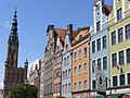
Right town

Old town

New garden

Hagelsberg: Bożego Ciała Church

Bischofsberg
Petershagen: ruin of the church

Suburb: Żabi Kruk

Storage island

Bleihof: today's Baltic Philharmonic (center)

Long garden

Niederstadt and New Motlawa

Straw dike on the Dead Vistula

Rudno / Kneipab


Web links
Footnotes
- ↑ Uchwała nr liii / 1550/10 Rady Miasta Gdańska PDF file, 73 KB; Retrieved June 23, 2012.
- ↑ Podział administracyjny Gdańska - Gdańsk - oficjalna strona miasta - Official website of the City of Gdańsk. As of January 12, 2011. Accessed June 23, 2012
Gdańsk Śródmieście | VII Dwór | Aniołki | Brętowo | Brzeźno | Chełm | Jasień | Kokoszki | Krakowiec-Górki Zachodnie | Letnica | Matarnia | Młyniska | Nowy Port | Oliwa | Olszynka | Orunia-Św. Wojciech-Lipce | Orunia Górna-Gdańsk Południe | Osowa | Piecki-Migowo | Przeróbka | Przymorze Małe | Przymorze Wielkie | Rudniki | Siedlce | Stogi | Strzyża | Suchanino | Ujeścisko-Łostowice | Wrzeszcz Dolny | Wrzeszcz Górny | Wyspa Sobieszewska | Wzgórze Mickiewicza | Zaspa-Młyniec | Zaspa-Rozstaje | Żabianka-Wejhera-Jelitkowo-Tysiąclecia