Gries (Hallein)
|
Adneter Gries ( district ) locality cadastral community Gries |
||
|---|---|---|
|
|
||
| Basic data | ||
| Pole. District , state | Hallein (HA), Salzburg | |
| Judicial district | Hallein | |
| Pole. local community | Hallein | |
| Coordinates | 47 ° 41 '11 " N , 13 ° 5' 46" E | |
| height | 447 m above sea level A. | |
| Residents of the village | 421 (January 1, 2020) | |
| Area d. KG | 32 ha | |
| Post Code | 5400 Hallein | |
| prefix | + 43/6245 (Hallein) | |
| Statistical identification | ||
| Locality code | 13626 | |
| Cadastral parish number | 56208 | |
| Counting district / district | Gries- Adneter Riedl (50205 014) | |
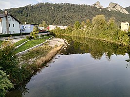
 The Almbach forms the northern border of Gries (on the left bank) |
||
| Source: STAT : index of places ; BEV : GEONAM ; SAGIS | ||
Gries (also Adneter Gries ) is a village , a cadastral municipality and a district of Hallein with 421 inhabitants (as of January 1, 2020) in the Hallein district in the Salzburger Land in Austria .
geography
location
Gries is located south of the Almbach in the eastern part of Hallein.
Neighboring districts
| Neualm | Adneter Riedl | |
| Hallein |

|
|
| Keep |
History and infrastructure
Incorporation
The Adneter Gries was incorporated into the city of Hallein together with the Adneter Riedl in 1938 as part of the greater area policy at the time.
Road connection
The district is located between Salzachtal Straße (B159) and Tauernautobahn (A10). and on Halleiner Landesstraße (L105), which leads to Salzburg on the right bank of the Salzach. The 20 km long Wiestal -Landesstraße (L107) through the Salzburg Pre-Alps to Hof bei Salzburg begins here . The Hallein motorway junction is also here (Exit 16), at motorway kilometer 19.4. The system, constructed as an indirect trumpet , connects the Wiestalstrasse via a roundabout , in the direction of the city the L105 and the B159 are connected via further roundabouts.
Public transport
The Hallein Abzw. Wiestalstraße stop is served by line 160. The Hallein Straßenmeisterei stop is served by line 41.
Road maintenance depot Tennengau

The Tennengau road maintenance facility is an office of the Salzburg state government and is located on Wiestal-Landesstraße near the Tauern motorway.
Web links
Individual evidence
- ↑ Statistics Austria: Population on January 1st, 2020 by locality (area status on January 1st, 2020) , ( CSV )
- ^ [1] The population of the city of Hallein, Rainer Lidauer and Malvine Stenzel, accessed on December 8, 2019
- ↑ MediaCube: Line network and area maps of the Salzburger Verkehrsverbund GmbH . In: Salzburger Verkehrsverbund GmbH . ( salzburg-verkehr.at [accessed on January 29, 2018]).
- ^ Tennengau road maintenance depot . In: Salzburger Nachrichten : Salzburgwiki .

