
Bürglen UR
| UR is the abbreviation for the canton of Uri in Switzerland and is used to avoid confusion with other entries of the name Bürglen . |
| Bürglen | |
|---|---|
 |
|
| State : |
|
| Canton : |
|
| District : | No district division |
| BFS no. : | 1205 |
| Postal code : | 6463 |
| Coordinates : | 693 338 / 192 299 |
| Height : | 525 m above sea level M. |
| Height range : | 447-2537 m above sea level M. |
| Area : | 53.06 km² |
| Residents: | 3977 (December 31, 2018) |
| Population density : | 75 inhabitants per km² |
|
Proportion of foreigners : (residents without citizenship ) |
6.1% (December 31, 2,014) |
| Mayor : | Markus Frösch (independent) |
| Website: | www.buerglen.ch |
 Bürglen UR |
|
| Location of the municipality | |
  |
|
Bürglen is a municipality in the canton of Uri in Switzerland .
geography

Bürglen, also known as Tellendorf, is located southeast of the canton capital Altdorf at the entrance to the Schächental . In addition to the village, there are numerous scattered settlements on both valley slopes. The Schächen flows through Bürglen .
Only 113 ha or 2.1% of the municipality is settlement area. Of this, 61 hectares are building or industrial areas and 46 hectares are traffic areas. Far more important is the agricultural area with 2733 ha or a share of 51.4%. These include large alpine areas, most of which are located behind the Kinzig Pass. These cover an area of 2022 ha. A further 702 ha are meadow and arable land. In addition, 1056 hectares or almost 20% of the municipal area are covered by forest and wood. Unproductive area comprises the rest of the municipal area, namely 1411 ha or 26.6%. It concerns almost exclusively areas without vegetation (high mountains) or areas with unproductive vegetation (high alpine vegetation).
Bürglen borders in the west on Attinghausen , Altdorf UR and Flüelen , in the north on Sisikon and the Schwyzerischen communities Riemenstalden and Muotathal , in the southeast on Unterschächen and Spiringen and in the south on Schattdorf .
population
| Population development | |
|---|---|
| year | Residents |
| 1743 | 910 |
| 1799 | 1150 |
| 1860 | 1312 |
| 1880 | 1482 |
| 1888 | 1497 |
| 1900 | 1656 |
| 1950 | 2723 |
| 1970 | 3401 |
| 1980 | 3456 |
| 2000 | 3878 |
| 2005 | 3962 |
| 2010 | 3955 |
The population grew sharply in the second half of the 18th century (1743–1799: +26.4%). This was followed by slower growth until 1860 (1799–1860: + 14.1%). Since then, with the exception of the 1880s and 1970s, the population has grown rapidly. From 1900 to 1950 by 1067 people or 64.4%; between 1950 and today by 1239 people or 45.5%. The reason for the enormous growth is the proximity to the traffic routes and the scenic location.
languages
The population speaks a highly Alemannic dialect. Almost the entire population speaks German as the everyday language. In the last census in 2000, 96.70% said German, 1.01% Serbo-Croatian and 0.46% Albanian as their main language.
Religions - denominations
The population used to be fully members of the Roman Catholic Church. The denominational relationships in 2000 still show the original structure. 3540 people were Catholic (91.28%). In addition, there were 4.74% Protestant Reformed and 0.83% Orthodox Christians, 0.74% Muslims and 1.50% non-religious. 23 people (0.59%) did not provide any information on their creed.
Origin - nationality
Of the 3962 residents at the end of 2005, 3823 (96.49%) were Swiss nationals. The majority of the immigrants come from Central Europe (Germany), Southern Europe (Italy) and the former Yugoslavia (Serbia / Montenegro and Croatia). At the 2000 census, 3,701 people (95.44%) were Swiss citizens; 70 of them had dual citizenship.
age structure
The church has a high percentage of younger people. While the proportion of people under the age of twenty makes up just under 28.36% of the local population, only just under 18.62% are senior citizens (60 years and older). The average age is 36 years.
The last census in 2000 showed the following age structure:
| Age | 0–6 years | 7-15 years | 16-19 years | 20-29 years | 30–44 years | 45–59 years | 60–79 years | 80 years and more |
| number | 384 | 497 | 219 | 477 | 916 | 663 | 571 | 151 |
| proportion of | 9.90% | 12.82% | 5.65% | 12.30% | 23.62% | 17.10% | 14.72% | 3.89% |
politics
legislative branch
The municipal assembly forms the legislature. It usually meets twice a year.
executive
The seven-member municipal council forms the executive . He works part-time. The current mayor is Markus Frösch (independent) (as of 2017). He heads the local council. The municipal council consists of the following parties: 1 representative of the FDP, 3 SVP, 1 SP, 1 CVP and 1 non-party member.
economy

In 2005 there were 126 farms offering 284 jobs. Industry and trade employed 727 people in 35 workplaces, the service sector in 79 companies 733 people (employment converted to full-time positions). The 2000 census showed 141 agricultural and forestry businesses with 346 employees. The 2001 census came to 33 industrial and commercial enterprises with 1008 and 76 service companies with 649 employees. Agriculture, which used to dominate, is still important. The Tellendorf was able to keep its rural appearance. This impression of a farming village is underlined by the large number of farms. No Uri municipality has more farms and more people employed in agriculture than Bürglen. Nevertheless, a large part of the employed citizens today work outside the farming profession. Of the employed people in Bürglen in 2000, 742 (39.22%) worked in their own community. In total, the place offered work for 1,334 people, of whom 742 (55.62%) were locals.
Bürglen is in the economic sphere of influence of the Altdorf / Schattdorf industrial center, where almost half of the employed citizens have their jobs. Most of the 1150 commuters do their work in other communities in the canton of Uri. Including 552 people in Altdorf, 167 in Schattdorf, 68 in Erstfeld, 40 in Flüelen and 22 in Seedorf. Important places of work outside the canton are the city of Lucerne (31 people) and the municipality of Schwyz (28), as well as Stans (22) in the canton of Nidwalden . There were also 592 inbound commuters. These came mainly from Altdorf (161 people), Schattdorf (155), Spiringen (33), Erstfeld and Seedorf (32 each), Flüelen (29), Unterschächen and Attinghausen (28 each) and Silenen (24).
Education and culture
School system
There are 5 school houses, as well as 3 kindergartens, 17 primary and 9 upper school departments. In 2006 there were 518 children who attended school in Bürglen. Around 120 schoolchildren eat a simple menu at the daily table (“soup”). These are mainly children who cannot go home during lunchtime due to long ways to school (longer than 30 minutes on foot).
youth
A youth club has been available for young people in Bürglen and the surrounding area since 1999.
history
The place is first mentioned in a document in 857 under the name Burgilla. At that time, King Ludwig the German gave the chapel in Bürglen including the serfs , tithes , fields, meadows, forests and all accessories as lifelong benefices to the priest Berold, probably because he spent many years with the king's daughter Hildegard , abbess of the monastery of St. Felix and Regula ( today's Fraumünster Zurich), faithfully served.
The parish church of St. Peter and Paul is mentioned for the first time in 875. The current building dates from 1681 and was built by Johann Jakob Scolar .
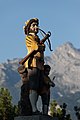
Bürglen is considered the home of Wilhelm Tell , the Swiss national hero.
Attractions

Bürglen Church

Tell Museum

Meier Tower

Tell Chapel
Tell fountain

Mrs. Tell with Wilhelm
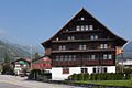
Haus Spielmatt (cultural property protection)

Chapel in the Riedertal


coat of arms
The municipal coat of arms shows the four towers of Bürglen , these still exist and date from the 12th century. The so-called Meier Tower exists in its original form. The second tower has housed the Tell Museum since 1966. The third and fourth towers form the foundation walls of the Hotel Tell and the rectory.
Personalities
- Josef Konrad Scheuber (1905–1990), clergyman and founder of the Tell Museum; Honorary citizen of Bürglen
- Lisa Elsässer (* 1951), writer, born in Bürglen.
- Bruno Risi (* 1968), multiple world champion in track cycling and multiple winner of six-day races , lives with his family in Bürglen.
- Dani Arnold (* 1984), extreme mountaineer, grew up in Biel ob Bürglen, lives in Bürglen.
Web links
- Official website of the municipality of Bürglen UR
- Hans Stadler: Bürglen (UR). In: Historical Lexicon of Switzerland .
- Bürglen UR on the ETHorama platform
Individual evidence
- ↑ Permanent and non-permanent resident population by year, canton, district, municipality, population type and gender (permanent resident population). In: bfs. admin.ch . Federal Statistical Office (FSO), August 31, 2019, accessed on December 22, 2019 .
- ↑ https://www.pxweb.bfs.admin.ch/Selection.aspx?px_language=de&px_db=px-x-0102020000_201&px_tableid=px-x-0102020000_201\px-x-0102020000_201.px&px_type=PX
- ↑ tell-buerglen.ch: Hotel Tell Bürglen. , Accessed March 17, 2010
Altdorf | Andermatt | Attinghausen | Build | Bürglen | Erstfeld | Flüelen | Göschenen | Belt pins | Hospental | Isenthal | Realp | Schattdorf | Seedorf | Seelisberg | Silenen | Sisikon | Spiringen | Undercuts | Water
Canton of Uri | Districts of the canton Uri | Municipalities of the Canton of Uri