
Bacher Lay
|
Bacher Lay
IUCN category none - not specified |
||
 Bacher Lay near Bad Marienberg (Westerwald) |
||
| location | Rhineland-Palatinate , Germany | |
| surface | 44.7 ha | |
| WDPA ID | 162315 | |
| Geographical location | 50 ° 39 ' N , 7 ° 59' E | |
|
||
| Setup date | 1996 | |

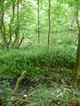
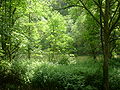
The Bacher Lay is a 44.7 hectare nature reserve in the Westerwaldkreis in Rhineland-Palatinate and a geotope of the Westerwald-Lahn-Taunus Geopark .
location
It is a disused basalt quarry , which is located between Bad Marienberg and Nisterau directly on the Black Nister, an inlet of the large Nister . The name is derived from the formerly independent place Bach , which is now part of the municipality of Nisterau; Lay in this case means quarry . The area extends in parts over the districts of Bad Marienberg, Bach, Eichenstruth and Stockhausen-Illfurth .
The Bacher Lay is characterized by a mighty, almost vertical basalt stone wall, which was created by the earlier basalt mining. The nearby "Pfaffenmal", an 18-meter-high columned basalt cone in the form of a mile, is also worth seeing.
It's about 4 kilometers on foot from the town center of Bad Marienberg to the Bacher Lay.
Nature reserve
The Koblenz district government issued an ordinance on this on October 28, 1996, in which the protective purpose is described as follows:
- "The protective purpose is the preservation and development of the 'Bacher Lay' with its standing and flowing waters with flat and steep bank areas, with its dry grass, tall herbaceous corridors and steep basalt walls as a habitat for rare animal and plant species that are threatened in their existence - especially amphibians, Reptiles and bird species as well as orchid species ”.
photos
Bacher Lay

Bacher Lay

Bacher Lay
Bacher Lay


See also
Individual evidence
- ↑ a b Ordinance of the Koblenz District Government of October 28, 1996 (PDF, 70 kB)
Web links

Bacher Lay | Breitenbach dam | Brinkenweiher | Dreifelder Weiher | Eisenbachwiesen | Fox chews | Haidenweiher | Hasenwiese | Hartenberg / Steincheswiese | Holzbach breakthrough | Holzbachtal | In the kump | Wisp of Light | Krombach dam | Malberg | Nesting meadow | Schimmelsbachtal | Seebachtal | Spießweiher | Quarry at the Breiten Berg | Stilt creek meadows | Beckershaid clay pit | Juniper heather near Westernohe | Wiedaue at Borod | Wölferlinger Weiher