
Krombach dam
| Krombach dam | |||||||
|---|---|---|---|---|---|---|---|
 |
|||||||
|
|||||||
|
|||||||
| Coordinates | 50 ° 37 '6 " N , 8 ° 8' 15" E | ||||||
| Data on the structure | |||||||
| Construction time: | 1946-1949 | ||||||
| Height above the river bed : | 14 m | ||||||
| Crown length: | 550 m | ||||||
| Power plant output: | 145 kW | ||||||
| Data on the reservoir | |||||||
| Altitude (at congestion destination ) | 523 m | ||||||
| Water surface | 95 ha | ||||||
| Storage space | 4.2 million m³ | ||||||
| Catchment area | 12 km² | ||||||

The Krombachtalsperre is a dam in the Westerwald , which was built from 1946 to 1949. The Rehbach , a tributary of the dill, is dammed . The Krombach dam is named after a small stream that flows into the dam between the town of Rehe and the Rehe campsite. In addition to generating electricity, it is used for flood protection and recreation. The northern part of the lake is a nature reserve. While the dam is in Hesse , most of the reservoir is in Rhineland-Palatinate . The former Herborn-Rennerod railway line was relocated for the construction of the barrier . The dam is the highest point in a chain of five hydropower plants that EAM operates.
location
The Krombachtalsperre is one kilometer south of Rehe (Westerwald) and two kilometers west of Driedorf - Mademühlen . One kilometer east of the village is the Driedorf reservoir and three kilometers north of Heisterberg is the Heisterberger Weiher .
Freetime activities
There is a holiday village and two campsites for recreation. Another resident is the sailing club Westerwald eV , which organizes several regattas a year, including the Hessen championships.
The dam is used by sailors and surfers from April to September. Sailing boats up to 20 m² in front of the wind are allowed. Motor boats are only permitted for rescue and safety purposes.
In summer the Krombachtalsperre is guarded every weekend by a delegation of voluntary helpers from the DLRG - Dill district or by guest guards from other local groups.
Krombachtalsperre nature reserve
The northern part of the Krombachtalsperre and its bank zone was designated as a nature reserve by the Koblenz district government on February 23, 1981 . The reserve has a size of about 47.5 hectares and is in the district of Deer . The border of the nature reserve is marked by a chain of buoys.
The protection purpose is "the preservation of the wetland with its water and swamp areas as well as its shallow water zones as a location for numerous rare plants and as a habitat in their population of threatened rare bird species for scientific reasons".
Landscape protection area Krombachtalsperre
On the Rhineland-Palatinate side, the “Krombachtalsperre Landscape Protection Area” is much larger, with an area of around 17.0 km². The usage restrictions in the landscape conservation area are lower than in the smaller nature reserve. It covers parts of the districts of Rehe , Oberrod , Westernohe , Rennerod , Emmerichenhain, Waigandshain and Homberg . The purpose of protection is "the preservation of the special landscape characteristics, their beauty and their recreational value as well as the prevention of adverse effects on the landscape budget, in particular the landscape factors soil, water, flora and fauna".
prehistory
In the area of today's reservoir there was probably a settlement by 1330 at the latest. It can no longer be determined today whether this was just the mill, first mentioned as such in 1431, or an entire village. The mill burned down in the Thirty Years War. It was rebuilt in 1645. By 1534 at the latest there was an artificially created pond in the manorial property. In 1873 it was drained.
See also
photos
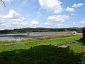
Dam of the Krombachtalsperre

Lido

Sailing boats


literature
- Hellmuth Gensicke : Parish and court of Emmerichenhain . In: Association for Nassau antiquity and historical research (Hrsg.): Nassauische Annalen . tape 101 . Publishing house of the Association for Nassau Antiquities and Historical Research, Wiesbaden 1990, p. 231-254 .
Web links
- Hessian State Office for Environment and Geology: Krombachtalsperre . In: Badeseen in Hessen, accessed on May 13, 2009
- Information about the Krombachtalsperre, municipality of Driedorf
- Nature conservation information on the dam
Individual evidence
- ↑ Hydropower - Commercial Customers | Energy in flux. Retrieved May 12, 2018 .
- ↑ SCWw News. Retrieved May 12, 2018 .
- ↑ SCWw News. Retrieved May 12, 2018 .
- ↑ Sailing and surfing - campsite at the Krombachtalsperre. Retrieved May 12, 2018 .
- ↑ SCWw News. Retrieved May 12, 2018 .
- ↑ guard station Krombachtalsperre - DLRG DLRG - District dill. Retrieved May 12, 2018 .
- ↑ a b Ordinance on the Krombachtalsperre nature reserve of the Koblenz district government of February 23, 1981. (PDF; 86 kB).
- ↑ Location map of the nature reserve in the landscape information system of the Rhineland-Palatinate nature conservation administration. ( Memento from August 2, 2013 in the web archive archive.today )
- ↑ Ordinance on the landscape protection area Krombachtalsperre of the district administrator of the Westerwaldkreis dated April 30, 1980. ( Memento of the original dated June 19, 2015 in the Internet Archive ) Info: The archive link was automatically inserted and not yet checked. Please check the original and archive link according to the instructions and then remove this notice. (PDF; 96 kB).
- ↑ Location map of the landscape protection area in the landscape information system of the Rhineland-Palatinate nature conservation administration. ( Memento from August 2, 2013 in the web archive archive.today )

Bacher Lay | Breitenbach dam | Brinkenweiher | Dreifelder Weiher | Eisenbachwiesen | Fox chews | Haidenweiher | Hasenwiese | Hartenberg / Steincheswiese | Holzbach breakthrough | Holzbachtal | In the kump | Wisp of Light | Krombach dam | Malberg | Nesting meadow | Schimmelsbachtal | Seebachtal | Spießweiher | Quarry at the Breiten Berg | Stilt creek meadows | Beckershaid clay pit | Juniper heather near Westernohe | Wiedaue at Borod | Wölferlinger Weiher