Bierzwnik (Powiat Choszczeński)
| Bierzwnik | ||
|---|---|---|

|
|
|
| Basic data | ||
| State : | Poland | |
| Voivodeship : | West Pomerania | |
| Powiat : | Choszczno | |
| Gmina : | Bierzwnik | |
| Geographic location : | 53 ° 2 ' N , 15 ° 40' E | |
| Residents : | 1200 | |
| Postal code : | 73-240 | |
| Telephone code : | (+48) 95 | |
| License plate : | ZCH | |
| Economy and Transport | ||
| Street : | DW160: Choszczno ↔ Dobiegniew | |
| Rail route : | Poznań – Szczecin railway line | |
| Next international airport : | Szczecin-Goleniów | |
| Gmina | ||
| Gminatype: | Rural community | |
| Gmina structure: | 42 localities | |
| 15 school offices | ||
| Surface: | 239.05 km² | |
| Residents: | 4686 (June 30, 2019) |
|
| Population density : | 20 inhabitants / km² | |
| Community number ( GUS ): | 3202012 | |
| administration | ||
| Address: | ul. Kopernika 2 73-240 Bierzwnica |
|
| Website : | www.bierzwnik.pl | |
Bierzwnik ( German Marienwalde ) is a village with the seat of a rural community of the same name in the powiat Choszczeński ( Arnswalde district ) in the Polish West Pomeranian Voivodeship .
Geographical location
The village of Bierzwnik ( Marienwalde ) lies in the Neumark and is to be distinguished from the place of the same name Bierzwnik ( Jägerswalde ) near Myślibórz ( Soldin ).
The village is located in the Woldenberg Lake District ( Pojezierze Dobiegniewskie ) on Voivodship Road 160 and is 24 kilometers from the city of Arnswalde ( Choszczno ) in the northwest and eleven kilometers from the city of Woldenberg ( Dobiegniew ) in the southeast.
The village of Bierzwnik ( Marienwalde )
history

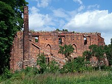
The history of the town of Marienwalde in the Neumark is closely connected to the history of the Marienwalde Monastery , which was founded in 1286 and abolished in 1549 as a result of the Reformation . After the abolition of the monastery, its goods were added to the sovereign estates; Johann von Küstrin converted the land of the monastery into the Marienwalde office and built the hunting lodge Jägersburg, which was then set up as a forecourt, but was dismantled around the middle of the 18th century and turned into a colony village. In 1607, a state-owned glassworks was built at the official seat, which was in operation until 1825.
Until 1945 the place belonged to the district of Arnswalde and with the district until 1938 to the Prussian province of Brandenburg , from 1938 to 1945 to the province of Pomerania .
Towards the end of the Second World War , Marienwalde was badly damaged in the spring of 1945 during fighting with the Red Army . After the end of the war, the region and the town were placed under Polish administration. Then the German village was renamed Bierzwnik . Unless the German residents had fled before the end of the war, they were subsequently expelled by the local Polish administrative authorities .
The village is now a district and the official seat of Gmina Bierzwnik in the powiat Choszczeński in the West Pomeranian Voivodeship (1975-1998 Gorzów Voivodeship ( Landsberg ad Warthe )).
Population numbers
- 1858: 693, including 16 Jews
- 1925: 1,205, including 15 Catholics and three Jews
- 1933: 1.311
- 1939: 1,294
Gmina Bierzwnik
General
The rural community Bierzwnik was formed in 1983 and covers 239.05 km². The municipality, which is defined by numerous lakes, has 4,710 inhabitants today, 1200 of whom live in the village of Bierzwnik.
The Gmina Bierzwnik has the uniform postal code 73-240 in all localities.
Community structure
The Gmina Bierzwnik is subdivided into 15 districts ("Schulzenämter") in a total of 42 localities:
- Districts ("Schulzenämter"):
|
|
- Other locations :
- Antoniewko ( Auenwalde ), Bożejewko ( Hammergut ), Budzice ( Neuhof ), Bukowie ( Buchenau )
- Chełmienko ( Wilhelm Berg ), Chyże ( Kietz ) Czapliska ( water field ), Dołżyna ( Neuhorst ) Gajno ( Hermannsruh ) Grzywna ( Waidmannsruh ) Kawno ( Hasselbruch ) Kłodzin ( Seeberg ) Kolečko ( Kölzigerberg ) Kosinek ( Augustenruh ) Kruczaj ( Marienwalde ) Krzywin ( Albertshof ) Kunica ( sows Werder ), Malczewo ( Rehfelde ), Ostromecko ( Reichssiedlung Kölzig ) Piaseczno ( Pätznickerie ) Pławienko ( New Plagow ) Przykuna ( Buchenwald ), Smędowa, Sojec ( Falkenhorst ) Trzebicz ( Broken pipe F ), Zdrójno ( Adolfsau ) and Zgorzel.
traffic
Street
The Gmina Bierzwnik is crossed in its entire length by the Voivodship Road 160 from northwest to southeast. It connects Suchań ( Zachan , on provincial road 10 ) and Choszczno ( Arnswalde ) with Dobiegniew ( Woldenberg ), Drezdenko ( Driesen ), Międzychód ( Birnbaum ) and Miedzichowo ( Kupferhammer , on provincial road 2 ).
rail
Bierzwnik has been connected to the rail network since 1847, when the Stargard in Pomerania (Stargard Szczeciński) - Woldenberg (Dobiegniew) line was built. Today the PKP line 351 runs here and extends from Stettin to Posen . The Gmina Bierzwnik with the two railway stations Bierzwnik and Rębusz ( Augustenwalde ) is on this route.
Sons and daughters (selection)
- Ernst Ludwig von Pfuhl (* 1716 on Gut Plagow; † 1798), royal Prussian general of the infantry, governor of the Spandau Citadel, governor of Potsda
literature
- Georg Wilhelm von Raumer : The Neumark Brandenburg in 1337 or Margrave Ludwig's the elder Neumärkisches Landbuch from this time . Berlin 1837, pp. 33-34.
- W. Riehl and J. Scheu (eds.): Berlin and the Mark Brandenburg with the Margraviate Nieder-Lausitz in their history and in their present existence . Berlin 1861, p. 448.
- Johannes Hinz : Pomerania. Signpost through an unforgettable country. Flechsig-Buchvertrieb, Würzburg 2002, ISBN 3-88189-439-X , p. 226 f.
Web links
- Gunthard Stübs and Pomeranian Research Association: The community of Marienwalde in the former Arnswalde district in Pomerania (2011).
Footnotes
- ↑ population. Size and Structure by Territorial Division. As of June 30, 2019. Główny Urząd Statystyczny (GUS) (PDF files; 0.99 MiB), accessed December 24, 2019 .
- ↑ a b Riehl and Scheu (1861), p. 448.
- ^ Heinrich Berghaus : Landbuch der Mark Brandenburg und des Markgrafthums Nieder-Lausitz , Volume 3, Brandenburg 1856, p. 380.
- ^ A b Michael Rademacher: German administrative history from the unification of the empire in 1871 to the reunification in 1990. arnswalde.html. (Online material for the dissertation, Osnabrück 2006).
- ↑ http://gemeinde.marienwalde.kreis-arnswalde.de/


