Dobiegniew
| Dobiegniew | ||
|---|---|---|

|
|
|
| Basic data | ||
| State : | Poland | |
| Voivodeship : | Lebus | |
| Powiat : | Strzelecko-Drezdenecki | |
| Gmina : | Dobiegniew | |
| Area : | 5.69 km² | |
| Geographic location : | 52 ° 58 ′ N , 15 ° 45 ′ E | |
| Height : | 58 m npm | |
| Residents : | 3061 (June 30, 2019) | |
| Postal code : | 66-520 | |
| Telephone code : | (+48) 95 | |
| License plate : | FSD | |
| Economy and Transport | ||
| Street : | Berlin - Gdansk | |
| Rail route : | Szczecin – Poznan | |
| Next international airport : | Szczecin-Goleniów | |
Dobiegniew [ dɔ'bʲɛgɲɛf ] ( German Woldenberg ) is a town in the powiat Strzelecko-Drezdenecki of the Lubusz Voivodeship in Poland . It is the seat of the town-and-country municipality of the same name with 6544 inhabitants (as of June 30, 2019).
Geographical location
The city is located in the Neumark , on the western edge of the Pojezierze Waleckie lake district, 46 kilometers northeast of Gorzów Wielkopolski (Landsberg an der Warthe) - the nearest larger city. The Great Lake extends to the north of the city . Through the city leading the country road 22 (droga krajowa 22) from Gorzow Wielkopolski to Elblag (Elbing) . The city's train station is on the Szczecin – Poznan line .
history
In the lowland of the Woldenberger Fließ, which is filled with swamps and lakes, there is evidence of pile dwelling settlement from the Neolithic Age . The first written source comes from the year 1250, when Duke Przemysł I of Greater Poland left the settlement “Dubegneve” to the Cistercian monastery in Ovinsk. It is believed that this was built on a fortification that has now disappeared, which served to protect the trade route from Küstrin via Landsberg and Friedeberg , which led over the Dragepass in Hochzeit to Schloppe and inland.
Around 1295 "Dubgnew" came to Brandenburg , Margrave Otto with the arrow confirmed in 1297 the ownership of the Ovinsk monastery in the city. The Ascanian margraves stayed several times in “Dubegnewe”, in 1303 the contract of the four margraves with the bishop Heinrich von Cammin was concluded here and in 1305 it was Woldemar who issued a certificate of ownership from the Marienwalde monastery .
"Dubegnewe" was first mentioned as a town in 1313, when the citizens bought the margravial mill for 500 silver marks . However, the town charter should have existed since the end of the 13th century. In 1333 the name "Waldinborg" can be traced for the first time, which completely replaced the old name within a short time. Woldenberg was a walled city, of the original city fortifications with 37 soft houses as well as several ramparts and ditches, only the ruins of a tower are preserved today.
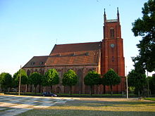
From 1402 to 1454 Woldenberg was part of the Neumark in the possession of the Teutonic Knights and in 1433 it was burned down by the Hussites . In 1455 the city came back to the Mark Brandenburg and received the rights of an immediate city . During this time, the three-aisled town church, a Gothic hall church made of bricks, was built . In 1581 Woldenberg was the scene of a witch trial in which five people were burned at the stake. Woldenberg was destroyed several times by city fires, the last larger one broke out in 1710. During the reconstruction, the market square was enlarged and the streets were redesigned according to a regular floor plan. The location of the town hall was moved from the middle of the market to its east side. Several trade routes to Posen , Stettin and Küstrin crossed in the city , which favored the settlement of merchants. The cloth making trade was also located there. Until the paper mill was shut down in 1847, Woldenberg was also a center for paper production.
Due to the Prussian administrative reform of 1815, Woldenberg was incorporated into the Brandenburg district of Friedeberg . In the 19th century it was connected to major traffic routes. The road from Berlin to Königsberg (Prussia) laid out in 1829, later Reichsstrasse 1 , led through Woldenberg. In 1847 the railway line to Stargard was inaugurated, which in 1849 was continued in a south-easterly direction to Kreuz as a connection to the Eastern Railway and from there to Posen .
1938 Woldenberg was together with the county Friedeberg in the Pomerania incorporated. This happened as part of a larger area reorganization, which is best known for the dissolution of the Grenzmark Posen-West Prussia province , which was administratively reorganized into the Grenzmark Posen-West Prussia administrative district .
During the Second World War , the Stalag II C was built in Woldenberg in 1939 , which was expanded between 1940 and 1941 to form the Oflag II C Woldenberg officer prison camp with an area of 25 hectares and which existed until 1945. Some of the prisoners in the camp were taken in several columns on foot in January 1945 to the west. A group of around 400 prisoners from the Woldenberg camp arrived in Murnau am Staffelsee in March 1945 . The approximately 4,000 prisoners remaining in the Woldenberg camp were released when the Red Army occupied the region on January 30, 1945 .
At the end of the Second World War, heavy fighting had taken place near Woldenberg at the beginning of 1945, in which 85 percent of the city was destroyed. The most important architectural monument, the late Gothic town church, was preserved, while large parts of the city center today consist of green spaces. In the spring of 1945 the city was occupied by the Red Army and soon afterwards placed under Polish administration by the Soviet military command . The entire indigenous population was subsequently expelled by the local Polish administrative authority and replaced by Poland .
Woldenberg synagogue
The synagogue was built in 1858. It was located at Junkerstrasse 9, at the corner of Brunnenstrasse, and was destroyed by the Nazis on the night of November 9-10, 1938, the night of the Reichspogrom .
Population development
- 1750: 1,291
- 1801: 1.721
- 1840: 2,900
- 1858: 3,772, including 22 Catholics and 119 Jews
- 1875: 4.089
- 1890: 4,676, including 44 Catholics and 157 Jews
- 1925: 4,787, including 143 Catholics and 60 Jews
- 1933: 5.103
- 1939: 5,344
- 2006: 3.152
local community
The urban-and-rural municipality (gmina miejsko-wiejska) Dobiegniew has an area of 351 km². The city itself and 13 villages with school boards belong to it.
sons and daughters of the town
- Gotthilf Samuel Falbe (1768–1849), classical philologist and high school director
- Alfred Beyer (1885–1961), physician and politician
- Friedrich Wilhelm Ahnefeld (1924–2012), anesthetist, university professor and medical officer in the Bundeswehr
- Jürgen Schröder (* 1935), Germanist at the University of Tübingen
- Martin Rupprecht (1937–2018), stage and costume designer.
literature
- Heinrich Berghaus : Land book of the Mark Brandenburg and the Markgrafthum Nieder-Lausitz , Volume 3, Brandenburg 1856, pp. 472-474.
- Paul van Nießen : History of the city of Woldenberg i. N. With the support of the Association for the History of Neumark and the City of Woldenberg . Burmeister, Stettin 1893.
- W. Riehl and J. Scheu (eds.): Berlin and the Mark Brandenburg with the Margraviate Nieder-Lausitz in their history and in their present existence . Berlin 1861, pp. 456-457.
Web links
- Gunthard Stübs and Pomeranian Research Association: The city of Woldenberg Nm. in the former Friedeberg district in Pomerania (2011).
- Woldenberg in the Neumark-Dobiegniew
- Information on the Woldenberg officers' camp. Archived from the original on February 18, 2013 ; accessed on July 7, 2018 .
- City website (Polish)
Individual evidence
- ^ Synagoga w Dobiegniewie. In: sztetl.org.pl. Retrieved July 7, 2018 .
- ↑ a b c d Riehl and Scheu (1861): pp. 456–457.
- ↑ a b c d District of Friedeberg. Archived from the original on November 14, 2009 ; accessed on July 7, 2018 .
- ↑ http://stadt.woldenberg.kreis-friedeberg.de/
- ↑ Główny Urząd Statystyczny ( page no longer available , search in web archives ) Info: The link was automatically marked as defective. Please check the link according to the instructions and then remove this notice. , accessed January 5, 2008.


