
Dune (island)
| dune | ||
|---|---|---|
 |
||
| Waters | German Bight | |
| Geographical location | 54 ° 11 '5 " N , 7 ° 54' 44" E | |
|
||
| length | 1.25 km | |
| width | 850 m | |
| area | 70 ha | |
| Highest elevation | 9.2 m above sea level NHN | |
| Residents | uninhabited | |
 |
||


Düne (more precisely: "the dune", North Frisian de Hallem ) is the only side island of the German North Sea island of Helgoland . Together with the main island, it belongs to the municipality of Helgoland and thus to the Schleswig-Holstein district of Pinneberg , the main part of which is almost 140 km south-east on the mainland north-west of Hamburg .
The flat sand island, also beach island , which was artificially enlarged in parts in the 20th century, is a refuge for sea birds , gray seals and harbor seals, among others . With its beaches it serves as a bathing island. The Helgoland-Düne airfield , the dune harbor , accommodation, the Helgoland Düne lighthouse and the Helgoland DGPS station are also located here .
Geographical location
The island of Düne is located 62 km northwest of the Elbe estuary and just under 1 km east of the main Heligoland island , which is the north-west boundary of the Heligoland Bay . From the main island is through the narrow strait anchor separated, the in North roads and Südreede (formerly also Nordhafen and Südhafen called) is divided.
The island is about 0.7 km² in size, a maximum of 1.25 km long in the west-northwest-east-southeast direction and up to 850 m wide in the northeast-southwest direction. Its highest point is 9.2 m above sea level. NHN .
story
→ for more information see the history section of the article Heligoland
The dune was originally part of a larger island of Heligoland. On the maps of the 16th century it is only connected to Heligoland as a peninsula via the initially wide isthmus (narrow isthmus) called de Woal . Around 1640 there was still the Witte Kliff (also called Wittkliff and formerly Witte Klyppe ) consisting of shell limestone and chalk in its northern part , which was about the same height as the reddish cliffs made of middle red sandstone of the main island. The cliff disappeared in 1711 due to the dismantling for building materials and soil erosion : During the New Year's flood of 1721 , which began on December 31, 1720 and ended on January 1, 1721, its remains and the isthmus were destroyed, making the dune one of the Main island separate island. It continued to shrink over time. Around 1935 the dune , now called Strand-Insel , only consisted of a 0.1 km² strip of sand in the shape of a comet .
In the National Socialist German Reich , the dune was a restricted military area . As part of the 1938 started project Hummerschere (expansion of dune and Helgoland the fortress with seaport ) was the island by the German government through Sandvor- and -aufspülungen increased, passing through additional construction of groynes and jetties about got its present form. The Helgoland-Düne airfield , which was mainly used as an emergency and alternative site during the Second World War (1939 to 1945), and anti-aircraft guns were installed. In 1941 the work was stopped. After the war ended, the dune and Heligoland were occupied by the United Kingdom .
Between 2008 and 2011 there were plans to reconnect the islands of Dune and Heligoland ; this was rejected in a referendum on June 26, 2011 with 54.74 percent of the votes cast.
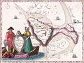
Heligoland and the dune formed an island in 1649

Heligoland and dune after the separation of 1757

Heligoland with dune in the east, historical map

Lighthouse on dune
.png)


Fauna, flora and fossils
Gray seals and common seals settle on the beaches of the dune , which is frequented by numerous sea birds such as oystercatchers , seagulls and turnstone .
The majority of the dune consists of gray and white dunes as well as shrubbery made of sea buckthorn , silver olive and potato rose . On the Aade in the south-east of the island, the rinsing area is populated by salted potash , sea mustard and chickweed . Inside the island there are two ponds with quite lush reeds and brackish reed beds.
The east beach, the former Aade peninsula , is a pure stone beach that is largely exposed to the unhindered erosion and accumulation activity of the North Sea. As a result, especially after storm surges, there is always a relocation of the debris and thus changes in the course of the bank. Here, let fossils of Belemnites ( "thunderbolts"), sea urchins and ammonites found. After major storms, these stones can also be found on the other beaches. Clams and clams can be found on all beaches.
Protected areas
→ For more information, see the Protected Areas section of the Heligoland article
The marine areas around the dune and Heligoland and small parts of both islands are parts of nature and bird protection as well as fauna-flora-habitat areas, including the Helgoland rock plinth nature reserve .

Turnstone on the beach of the dune

Gray seal on the beach of the dune
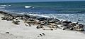
Seals on the north beach of the dune

Coastal chamomile on the flushing edge of the dune

Chickweed on the flushing edge of the dune


Cemetery of the Nameless
On the dune there is the Nameless Cemetery for the dead washed up on the beach. The dead have been buried on the dune for many centuries . The location of the cemetery - like the island itself - has changed many times. It is one of the cemeteries of the homeless , with a bell as well as monuments and gravestones for deceased sea passengers and seafarers.
In the cemetery there is a memorial stone for the unknown dead - the original purpose of the facility - as well as memorial stones for the dead in the naval battle off Heligoland (1864) , the crews of the boats of the Navy S 178 , G 171 , Lower Elbe and the im, which sank in 1912 and 1913 Naval airship LZ 14 / L 1 that crashed off Heligoland in September 1913 (remains of a larger monument from 1914). Another memorial stone was erected for the crew of the sea rescue cruiser Adolph Bermpohl , who was seriously injured but not sunk , and who fell victim to the hurricane of February 23, 1967 during the sea rescue operation off Heligoland, and for the lifeguards of the German Society for the Rescue of Shipwrecked People who remained at sea. There is also a memorial stone for three victims during the exploration of the seabed off Heligoland by an underwater laboratory. In 2016 a stele was erected for deceased fans of the Rock'n'Roll Butterfahrt . In addition, the bereaved of buried at sea use the site as a memorial site by inscribing small stones with the names of their dead. The cemetery for the dead without names has become a cemetery for names without the dead.
In the cemetery of the nameless, the bell given by the bell foundry JF Weule in Bockenem in Ambergau to the municipality of Helgoland on the day of the release on March 1, 1952, was attached to wooden parts of a sailing ship stranded off Helgoland. The Heligoland SAR helicopter squadron has taken on the sponsorship of the cemetery.
The poem "You nameless in the white sand ...", carved in stone here today, can already be traced on a dune postcard before the First World War. In 1920 it was cast in bronze and repositioned. It was written in 1903 by the longtime island guest, privy councilor Dr. med. Hesselbarth (1858–1931) from Berlin.
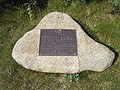
Memorial stone of the DGzRS in the cemetery of the nameless

Bell from the J. F. Weule bell foundry in Bockenem at the nameless cemetery (2016)


tourism

→ For more information, see the Tourism section of the Helgoland article
At the beginning of the 20th century by boat from bathing Helgoland to dune had traveled people isolated beaches of the island: Women in northwestern Damenbad and men in the south-east of it located Herrenbad . There was a family pool on the opposite coast of the island .
Nowadays the north and south beaches serve as bathing beaches. When the water level is very low, remnants of the Witte Kliffs can still be seen on the north beach . Due to its favorable wind and current conditions, the south beach is a popular bathing resort for families with small children. There is a beach restaurant and the lighthouse Helgoland Düne .
There is a campsite and two bungalow settlements as accommodation . The "hill" Jonny Hill offers a panoramic view of the dune and Heligoland .
traffic
ship
→ For further information see the section Ship of the article Heligoland
The dune is regularly approached by a ferry during the day: the Witte Kliff dune ferry takes over the transfer of bathers and passengers from the inland port of the main island to the dune port . She is a two-engine catamaran in GRP construction, which was built in 1997 by the Fassmer shipyard. In terms of construction, it corresponds to the tender boats that Fassmer produces for cruise ships, but in contrast to these, it has an open stern with around 15 seats outside. In the summer season, if required, Börteboats also run from the seaside resort ships directly to the dune harbor. This is typically the last port boat from a ship.
plane


→ For more information see the Air section of the Helgoland article
In the eastern part of the island is the Helgoland-Düne airfield , which opened in 1962 and is used daily by small single- and twin-engine aircraft, weather permitting. It has three runways. There are scheduled connections to some airports on the coastal mainland. There are traffic lights and signs warning pedestrians of planes landing at low altitude. The dune taxi connects the airport with the ferry terminal. It is one of the few land vehicles with internal combustion engines in the municipality of Helgoland, where according to § 50 StVO no motor vehicles or bicycles may be driven.

DGPS station Helgoland
The small transmission mast of the DGPS station Helgoland for maritime traffic safety is on the island of Düne . The frequency is 298.5 kHz . The useful radio range is around 285 km.
Individual evidence
- ↑ Willy Krogmann (founder), continued by Nils Århammar and Ritva Århammar: Helgoland dictionary. (PDF; 5.3 MB) p. 108 , accessed on August 27, 2020 .
- ↑ a b c Düne and Helgoland , map from 1910 in: Baedeker’s Northern Germany…; Handbook for Travelers, at commons.wikimedia.org
- ↑ Map services of the Federal Agency for Nature Conservation ( information )
- ↑ Britta Walbrun: The flora and vegetation of the island of Helgoland . Diploma thesis University of Göttingen, 1985.
- ↑ Cemetery of the Nameless. In: Kurverwaltung Nordeseeheilbad Helgoland (ed.): Helgoland 1989 (host directory with ABC of the island of Helgoland), p. 33.
- ^ Erwin Weber: Helgoland Chronicle IV / 1. Reprint 1976, p. 150; Heligoländer Heimat-Bund, October 1926 and January 1931.
- ^ DGPS Station Helgoland , accessed on December 26, 2016, on wsv.de
Web links
- Side by side: Helgoland and the dune , on helgoland.de

Schleswig-Holstein: Heligoland | Dune | Blauort | Trischen - Hamburg: Scharhörn | Niger horns | Neuwerk - Lower Saxony: Hoher Knechtsand | Mellum
West Frisian Islands - East Frisian Islands - North Frisian Islands