
Dalmatian train
| Čapljina – Trebinje / Gruž / Zelenika | |||||||||||||||||||||||||||||||||||||||||||||||||||||||||||||||||||||||||||||||||||||||||||||||||||||||||||||||||||||||||||||||||||||||||||||||||||||||||||||||||||||||||||||||||||||||||||||||||||||||||||||||||||||||||||||||||||||||||||||||||
|---|---|---|---|---|---|---|---|---|---|---|---|---|---|---|---|---|---|---|---|---|---|---|---|---|---|---|---|---|---|---|---|---|---|---|---|---|---|---|---|---|---|---|---|---|---|---|---|---|---|---|---|---|---|---|---|---|---|---|---|---|---|---|---|---|---|---|---|---|---|---|---|---|---|---|---|---|---|---|---|---|---|---|---|---|---|---|---|---|---|---|---|---|---|---|---|---|---|---|---|---|---|---|---|---|---|---|---|---|---|---|---|---|---|---|---|---|---|---|---|---|---|---|---|---|---|---|---|---|---|---|---|---|---|---|---|---|---|---|---|---|---|---|---|---|---|---|---|---|---|---|---|---|---|---|---|---|---|---|---|---|---|---|---|---|---|---|---|---|---|---|---|---|---|---|---|---|---|---|---|---|---|---|---|---|---|---|---|---|---|---|---|---|---|---|---|---|---|---|---|---|---|---|---|---|---|---|---|---|---|---|---|---|---|---|---|---|---|---|---|---|---|---|---|---|---|---|---|---|---|---|---|---|---|---|---|---|---|---|---|---|---|
 Train of the Dalmatian Railway passing through Herceg Novi (Castelnuovo)
| |||||||||||||||||||||||||||||||||||||||||||||||||||||||||||||||||||||||||||||||||||||||||||||||||||||||||||||||||||||||||||||||||||||||||||||||||||||||||||||||||||||||||||||||||||||||||||||||||||||||||||||||||||||||||||||||||||||||||||||||||
 | |||||||||||||||||||||||||||||||||||||||||||||||||||||||||||||||||||||||||||||||||||||||||||||||||||||||||||||||||||||||||||||||||||||||||||||||||||||||||||||||||||||||||||||||||||||||||||||||||||||||||||||||||||||||||||||||||||||||||||||||||
| Gauge : | 760 mm ( Bosnian gauge ) | ||||||||||||||||||||||||||||||||||||||||||||||||||||||||||||||||||||||||||||||||||||||||||||||||||||||||||||||||||||||||||||||||||||||||||||||||||||||||||||||||||||||||||||||||||||||||||||||||||||||||||||||||||||||||||||||||||||||||||||||||
| Maximum slope : | 28 ‰ | ||||||||||||||||||||||||||||||||||||||||||||||||||||||||||||||||||||||||||||||||||||||||||||||||||||||||||||||||||||||||||||||||||||||||||||||||||||||||||||||||||||||||||||||||||||||||||||||||||||||||||||||||||||||||||||||||||||||||||||||||
| Minimum radius : | 100 m | ||||||||||||||||||||||||||||||||||||||||||||||||||||||||||||||||||||||||||||||||||||||||||||||||||||||||||||||||||||||||||||||||||||||||||||||||||||||||||||||||||||||||||||||||||||||||||||||||||||||||||||||||||||||||||||||||||||||||||||||||
|
|||||||||||||||||||||||||||||||||||||||||||||||||||||||||||||||||||||||||||||||||||||||||||||||||||||||||||||||||||||||||||||||||||||||||||||||||||||||||||||||||||||||||||||||||||||||||||||||||||||||||||||||||||||||||||||||||||||||||||||||||
 |
|||||||||||||||||||||||||||||||||||||||||||||||||||||||||||||||||||||||||||||||||||||||||||||||||||||||||||||||||||||||||||||||||||||||||||||||||||||||||||||||||||||||||||||||||||||||||||||||||||||||||||||||||||||||||||||||||||||||||||||||||
The Dalmatian Railway or Zelenika Railway was a narrow-gauge railway line in Bosnian gauge from Čapljina to Zelenika with wing tracks from Hum to Podgorica and from Uskoplje to Gruž near Dubrovnik .
Geographical location
The railway line ran in Bosnia and Herzegovina and Dalmatia in Croatia .
history
prehistory

In the Austrian Kingdom of Dalmatia of the Austro-Hungarian Monarchy , a large part of the passenger and freight traffic was covered by ship connections on the northern Adriatic coast. The Austro-Hungarian army leadership feared in case of capture of the territorial waters of Italy that Dalmatia would have been cut off from Austria. The Bosna and Narenta Railway , built after the occupation of Bosnia and Herzegovina , established a land connection to Austria-Hungary from 1891.
The running parallel to the Dalmatian coast railway line joined at the Gabela Narentabahn with the then Marine port Zelenika in the Bay of Kotor (Bay Cattaro). The construction of the Dalmatian Railway was primarily based on military and strategic interests. But the tourist value of the railway was also undisputed.
Rivalries between Austria and Hungary prevented the connection of the Dalmatian port of Split to the railroad. As a replacement, the construction of a junction from Uskoplje to Gruž , the port of Dubrovnik, was taken on. This wing line was built out of economic interests, because the Ragusa port city of Gruž offered less space than Split, but in contrast to Metković on the Narenta Railway, it was accessible by large merchant ships . Dubrovnik wanted a rail connection for the first time in 1868, but met little approval in Vienna before the occupation of Bosnia .
The branch line from Hum to Trebinje was built to supply the garrison on the Montenegrin border and made it possible to develop the fruit, tobacco and wine growing area there.
Construction and first years of operation


In 1897 planning and construction work began. The line was not chosen along the coast to protect the railway from artillery fire from the Adriatic. The actual construction of the line began a year later and was associated with great difficulties. The climatic conditions with maximum temperatures in summer and the icy bora and torrential downpours in autumn and winter made the work extremely difficult. In the Narenta Valley, malaria broke out among construction workers. From Hum a waterless and uninhabited karst area had to be overcome. The water for the workers and for the operation of the steam locomotives could only be obtained from deep wells and rainwater in cisterns .
On July 16, 1901, the route Gabela – Hum – Uskoplje – Zelenica, and on July 17, 1901, the Hum – Trebinje and Uskoplje – Gruž routes were opened in the presence of the highest dignitaries from politics and administration. The section Čapljina – Hum – Trebinje / Uskoplje – Glavska belonged to the Bosnian – Herzegovinian State Railways (BHStB). The sections Uskoplje – Zelenika and Glavska – Gruž were owned by the kk state railways (kkStB), but were operated by the BHStB. The passenger trains from Sarajevo to Gruž were equipped with comfortable rolling stock. After four years of operation, 126,000 passengers and 28 million gross tons of goods were transported on the Dalmatian Railway. In freight transport, the steep route turned out to be costly. Nevertheless, the port of Dubrovnik in Gruž developed into the main transshipment point for Bosnian goods.
First World War
.jpg)
At the beginning of the 20th century, the rapid transport of troops and materials by rail was an important prerequisite for successful warfare. The low capacity of the Bosnian-Herzegovinian narrow-gauge network became evident at the beginning of the First World War . The eastern and southern borders of Bosnia and Herzegovina were among the most important military lines of operation in the Austro-Hungarian offensive against Serbia and Montenegro . Lack of supplies was a major reason why a victory was not achieved quickly.
Kingdom of Yugoslavia
After the collapse of the Habsburg monarchy , the Dalmatian Railway came to the railways of the Kingdom of Serbia, Croatia and Slovenia (SHS) and later to the Yugoslav State Railways (JDŽ / JŽ). The existing rail network was expanded and the Hum – Trebinje branch extended on November 20, 1931 by 42.3 kilometers to Bileća . On July 12, 1938, the 71.3 kilometer long continuation to Nikšić was opened to traffic.
Socialist Yugoslavia

From 1948 the route was extended again behind Nikšić to Podgorica.
At that time there was a connection to the Antivari Railway , which, however, had a track width of 600 mm in its northern section. The network of the Dalmatian Railway had thus reached its greatest extent, but this only lasted about 15 years. The railway increasingly suffered from competition from road traffic. The main lines of the Yugoslav narrow gauge network were on standard gauge umgespurt , such as in 1965, the route Nikšić-Podgorica. In the last few years of operation, the travel time of the fastest trains between Čapljina and Dubrovnik was just under three hours (average speed 44 km / h) and between Čapljina and Nikšić 6:40 hours (average speed: 39 km / h).
Another part of the route was abandoned. Tito's ambitions were for a better connection between Belgrade and the sea. The Belgrade – Bar line planned in the 1960s leads to the Adriatic coast via Montenegro instead of Sarajevo . The Dalmatinerbahn lost its importance for transit traffic. The last train to Zelenika went to Dubrovnik on June 30, 1968 and May 30, 1976.
Route description
The 114 kilometer-long Herzegovinian section to Glavska began in Gabela. From Čapljina to Gabela, the trains of the Dalmatian Railway use the Narentabahn track. Shortly after the junction, the railway crossed the Narenta (Neretva) and then the Krupa on a 130-meter-long railway bridge . With the help of a loop , the trains overcame a range of hills before reaching the Trebišnjica valley at Hutovo with a gradient of 12 to 17 per thousand . On this section the railway ran over several large dams, through rock cuts and tunnels. The route followed on the right side of the valley of the Trebišnjica in order to be protected from flooding and reached Popovo Polje at Turkovići . At Poljice the Dalmatian Railway had reached the end of Popovo Polje and followed the Trebišnjica on to Hum, where the 16.6 kilometer branch line branched off to Trebinje .
The trunk line left the Trebišnjica valley near Hum. The railway branched off at Uskoplje. A branch line with a length of 16.5 kilometers crossed the border with Dalmatia and led down to the Dalmatian Adriatic port in Gruž, for which she made use of a 276 meter long spiral tunnel and a loop. The main route continued to Glavska to reach the highest point of the route and the border with Dalmatia.
From the high plateau of Glavska, the 53.4 kilometer long Dalmatian section led down to Čilipi, initially with a 20 to 25 per thousand gradient through a 410 meter long spiral tunnel and a loop. From Gruda the route rose again at 25 per mille to overcome a ridge of 185 meters above sea level. The last few kilometers led down to the Zelenika terminus on the scenic Bay of Kotor.
Todays use
A large part of the route is used as a roadway . Other sections serve as access roads to residential buildings and have been paved. The bus station and the ferry port facilities are located on the former Gruž railway station. The section between Igalo and Zelenika now serves as a scenic pedestrian link along the Adriatic coast.
Picture galleries
Recordings from the operating time

Locomotive JŽ 83-146 with a passenger train in Čapljina, 1968.

Iron bridge at Gabela over the Narenta .
The branch to Gruž branched off in Uskoplje.
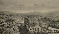
The port of Gruž near Dubrovnik developed into an important transshipment point.

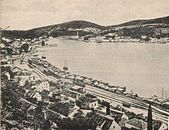
At Herceg Novi , the train offered a delightful view of the harbor and the sea.

The terminus Zelenika was the southernmost station of the Austro-Hungarian Empire .


Reuse of the infrastructure

The Narenta Bridge at Gabela is now used for road traffic.

Embankment with dismantled track at Popovo Polje .
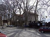
Next to the former Trebinje station , a parked steam locomotive reminds of the Dalmatian Railway .

The railway line at Herceg Novi is now used as a footpath to stroll along the Bay of Kotor.

The Zelenika station building is used as a residential building.


literature
in alphabetical order by authors / editors
- Helga Berdan: Austria-Hungary's power politics and railway construction in Bosnia-Herzegovina 1872 - 1914. (PDF; 8.3 MB) Diploma thesis at the University of Vienna , accessed on March 1, 2016 .
- Slavko Burzanović, Branislav Kovačević, Branislav Marović, Marijan Mašo Miljić, Šerbo Rastoder: 100 godina željeznice Crne Gore (100 years of railways in Montenegro). Podgorica 2009 (Serbian).
- Keith Chester: The Narrow Gauge Railways of Bosnia-Hercegovina . Stenvalls, Malmö 2006, ISBN 91-7266-166-6 .
- Keith Chester: Bosnia-Hercegovina Narrow Gauge Album . Stenvalls, Malmö 2010, ISBN 978-91-7266-176-9 .
- Keith Chester: The Railways of Montenegro. The Quest for a Trans-Balkan Railway . Frank Stenvalls, Malmö 2016. ISBN 978-91-7266-194-3
- Deutsche Bundesbahn : foreign curriculum. Summer 1974 .
- Michael Franke: Analysis of Railway Landscapes. (PDF; 12.5 MB) Chapter 5.1 Railway history in Dalmatia. Master's thesis at the University of Natural Resources and Life Sciences, Vienna , April 2013, pp. 35–43 , accessed on April 1, 2016 .
- Nick Lera: Narrow gauge timetables from 1961. In: The 76 cm gauge railways of Yugoslavia. Retrieved March 1, 2016 .
- NN: Maps of the Franzisco-Josephinische Landesaufnahme : Historical maps of the Habsburg monarchy. Austrian State Archives , accessed on March 1, 2016.
- Victor von Röll : Encyclopedia of the Railway System. Bosnian-Herzegovinian Railways. Retrieved March 1, 2016 .
- Werner Schiendl : The railways in Bosnia and Herzegovina 1867-1918 . Edition Bahn im Film, Vienna 2015, ISBN 978-3-9503096-5-2 .
- Werner Schiendl, Franz Gemeinböck: The railways in Bosnia and Herzegovina 1918–2016 . Edition Bahn im Film, Vienna 2017, ISBN 978-3-9503096-7-6 .
- JR von Wenusch: The railways of Dalmatia, Bosnia and Herzogewina. (Digitized at TU Cottbus, PDF; 33.1 MB) In: Journal of the Austrian Association of Engineers and Architects . Year 1903, issue 36, page 491ff., Accessed on March 1, 2016 .
Web links
- Pruga uzanog kolosjeka Mostar – Čapljina – Dubrovnik on the Serbian-speaking forum “Forum ljubitelja železnica” with lots of photos
- Pruga uskog koloseka Uskopje – Herceg Novi – Zelenika on the Serbian-speaking forum “Forum ljubitelja železnica” with lots of photos
- From Sarajevo to Dubrovnik in 1967 A selection of photos by Dave Sallery. In: The 76 cm gauge railways of Yugoslavia.
- Dubrovnik to Sarajevo in 1965 A selection of photos by Charlie Lewis. In: The 76 cm gauge railways of Yugoslavia.
- Dubrovnik to Capljina in 1972 A selection of photos by Jim Horsford. In: The 76 cm gauge railways of Yugoslavia.
- Discovering the narrow gauge in 2007 A selection of photos by Stuart Redding. In: The 76 cm gauge railways of Yugoslavia.
- The line to Dubrovnik today A selection of photos by Damir Fejzagic. In: The 76 cm gauge railways of Yugoslavia.
Remarks
- ↑ According to DB: international rate book Summer 1974 : km 120.
- ↑ a b Until 1918: Gravosa .
- ↑ a b Until 1918: Ragusa .
- ^ Up to 1918: Ragusa Vecchia .
- ↑ From 1908: Bosnian-Herzegovinian State Railways (BHLB).
- ↑ Železnice Kraljevine Srba, Hrvata i Slovenaca.