Middoge
|
Middoge
Wangerland municipality
Coordinates: 53 ° 38 ′ 5 ″ N , 7 ° 50 ′ 37 ″ E
|
||
|---|---|---|
| Height : | 2 m above sea level NN | |
| Incorporation : | 1933 | |
| Incorporated into: | Wangerland, first municipality from 1933 to 1948 | |
| Postal code : | 26434 | |
| Area code : | 04463 | |
|
Location of Middoge in Lower Saxony |
||

Middoge is a district of the municipality of Wangerland in the district of Friesland in northern Lower Saxony .
geography
The Wurtendorf Middoge is located in the so-called Jeverland . The North Sea coast is 9 kilometers to the north. The place is 20 kilometers northwest of Wilhelmshaven and 7 kilometers north of Jever . The federal highway 461 , which leads from Wittmund to Harlesiel on the North Sea, runs 3 kilometers to the west.
history
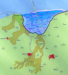
The settlement of Middoge is closely related to the dike in the old Harle Bay . Like some East Frisian islands , the place has the designation “oge” (eye) in its place name with the local specification “Midd” (middle). The name Middoge (middle island) thus referred to its island-like location in the former Harle Bay. Middoge is in the area of the " Golden Line ". It was created in the 17th century as the border between the Principality of East Friesland and the County of Oldenburg . Today it separates the two districts of Wittmund and Friesland .
Attractions
church
The ev.-luth. Church is a small, single-nave brick building from the late 15th century. The west wall and west tower date from around 1800. The exterior of the choir was renewed in 1912. In the 15th century the parish belonged to the diocese of Bremen and was subordinate to the Sendkirche in Hohenkirchen .
In the cemetery there is a richly decorated grave stele from 1708.
literature
- Middoge in: Georg Dehio : Handbook of German Art Monuments . Bremen Lower Saxony. Munich / Berlin 1992, p. 947
- History workshop Wangerland eV: Middoge - Een besünner Dämp . 1997.
- Hermann Haiduck: The architecture of the medieval churches in the East Frisian coastal area . 2nd Edition. Ostfriesische Landschaftliche Verlags- und Vertriebs-GmbH, Aurich 2009, ISBN 978-3-940601-05-6 , p. 192, 197 .
- Axel Bürgener , Klaus Siewert: Saalkirchen im Wangerland , Verlag "Auf der Warft", Münster - Hamburg - Wiarden 2015, ISBN 978-3-939211-97-6 , p. 23 ff.


