Schwäbisch Hall-Weckrieden airfield
| Schwäbisch Hall-Weckrieden airfield | |
|---|---|

|
|
| Characteristics | |
| ICAO code | EDTX |
| Coordinates | |
| Height above MSL | 395 m (1296 ft ) |
| Transport links | |
| Distance from the city center | 2 km east of Schwäbisch Hall |
| Local transport | bus |
| Basic data | |
| operator | Motorfliegerclub Schwäbisch Hall e. V. |
| Start-and runway | |
| 08/26 | 584 m × 40 m grass |
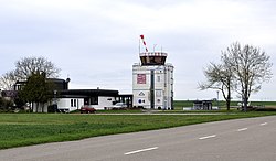
The airfield Schwäbisch Hall Weckrieden is a German airfield in Schwaebisch Hall - Weckrieden . It is classified as a special landing site .
The Schwäbisch Hall-Hessental airfield is 700 m to the south, with a concrete runway and a grass runway.
use
The airfield is used by the local air sports clubs, especially by microlight flyers, hang gliders and parachutists.
Directions
By bus: Line 5 of the Schwäbisch Hall city bus, Flugplatz stop. By car: In the east of Schwäbisch Hall, directly north of the Hessental district and east of the Weckrieden district.
Specialty
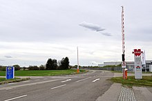
The Schwäbisch Hall-Hessental airfield (Adolf Würth Airport) is located 700 m to the south . The two airfields are the only ones in Germany that are connected by a taxiway . Aircraft on the ground can use this taxiway to taxi from one airport to the other. Since the taxiway leads over a public road, there is an intersection on the road that is secured with barriers . The barriers can be operated by the flight control.

