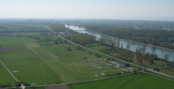
Herrenteich airfield
| Herrenteich | |
|---|---|

|
|
| Characteristics | |
| ICAO code | EDEH |
| Coordinates | |
| Height above MSL | 94 m (308 ft ) |
| Transport links | |
| Distance from the city center | 7.5 km southwest of Schwetzingen , 5 km northwest of Hockenheim |
| Street | K 4250 |
| Basic data | |
| operator | SFC Schwetzingen |
| Start-and runway | |
| 22/04 | 635 m × 30 m grass |
The airfield Herrenteich is a special airfield . It is operated by SFC Schwetzingen , which also accounts for a large part of the flight movements at the field. In addition, a large part of the jumping operation of the FSC Mannheim takes place here. The airfield is on the Rhine and is close to Hockenheim , Speyer and Ketsch .
Clubs and flight schools
There are two flight schools or clubs at the Herrenteich airfield:
- Sportfliegerclub Schwetzingen e. V.
- Parachute Sportclub Mannheim e. V.
Flood
Due to its location on the Rhine, the airfield is usually flooded during floods, despite dams . Drying after the flood sometimes takes several weeks, during which time no flight operations are possible.
Incidents
On August 3, 2017, a Pilatus PC6 Porter with a pilot and ten parachutists on board collided with a tractor that was standing on the apron. There was considerable property damage - but nobody was injured.
Web links
Individual evidence
- ↑ Propeller machine collides with tractor - Rhein-Neckar-Zeitung, August 3, 2017