
Albstadt-Degerfeld airfield
| Albstadt-Degerfeld airfield | |
|---|---|

|
|
| Characteristics | |
| ICAO code | EDSA |
| Coordinates | |
| Height above MSL | 891 m (2923 ft ) |
| Transport links | |
| Distance from the city center | 3 km east of Albstadt- Tailfingen |
| Basic data | |
| operator | Luftsportverein Degerfeld e. V. |
| Start-and runway | |
| 09/27 | 960 m × 30 m grass |
The Albstadt-Degerfeld airfield is a German special airfield in Albstadt , Zollernalbkreis, in Baden-Württemberg . It is approved for aircraft up to 1500 kg. The area is used for gliding and belongs to the Luftsportverein Degerfeld e. V.
The airfield is 891 m above sea level. This makes it the second highest airfield in Germany after the Wasserkuppe airfield and the highest in Baden-Württemberg.
location
The site is three kilometers east of the Albstadt district of Tailfingen on the Alb plateau. The community of Bitz is in the immediate vicinity . The approach from Stuttgart is via the B 27 and the B 32 , then the L 360 and the K 7101 .
Weather station
One of the three weather stations in Albstadt is located on the edge of the airfield . The secondary weather station Albstadt - Degerfeld ( Doline ) 48 ° 14 ′ 55.6 ″ N , 9 ° 3 ′ 21.8 ″ E is said to have recorded a temperature of −36.1 ° C on March 1, 2005, while the Albstadt station was at the same time shows a minimum temperature of only −15.9 ° C. Instead of the typical low mountain range, the Doline-Degerfeld station shows the special microclimate of a cold-air lake in a depression.
gallery

building

Albstadt-Degerfeld airfield
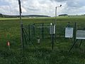
Weather station, runway and building behind it

Ju 52 HB-HOS of JU-AIR at the airfield festival (2016)

Start of an ASK 13 on the Degerfeld

Aerobatics with the Mudry CAP-10B during an air show


.jpg)


Web links
- Official website of the Degerfeld air sports club
- Free and free VFR visual flight card from Albstadt-Degerfeld Airport (EDSA)
- Airports.de. Retrieved August 24, 2017 .
Individual evidence
- ^ Degerfeld sinkhole. In: Project Kaltluftseen. Marco Kaschuba, archived from the original on June 13, 2014 ; accessed on March 13, 2018 .
- ^ Albstadt - Weather