Frankenhain (Schwalmstadt)
|
Frankenhain
City of Schwalmstadt
Coordinates: 50 ° 55 ′ 32 ″ N , 9 ° 9 ′ 32 ″ E
|
|
|---|---|
| Height : | 294 (270-300) m |
| Area : | 1.67 km² |
| Residents : | 269 (Dec. 31, 2018) |
| Population density : | 161 inhabitants / km² |
| Incorporation : | December 31, 1970 |
| Postal code : | 34613 |
| Area code : | 06691 |
|
Frankenhain
|
|
Frankenhain is a district of Schwalmstadt in the north Hessian Schwalm-Eder district .
Geographical location
Frankenhain is a two-line street village based on a plan on a field ridge. In the north and northwest, the place drops steeply into the wooded Katzenbachtal, to the southwest, on the other hand, the location slopes slightly towards the Schwalm and Wieratal .
Frankenhain is on the district road 102 and can be reached via the state road 3155 from Treysa to Sachsenhausen . Not far from the village, the third to last section of the federal motorway 49 has been built since 2011 , which leads from the current end of the expansion near Neuental to Schwalmstadt, including the approximately 900 meter long "Frankenhain Tunnel".
history
Today's Frankenhain is mentioned for the first time in 1701, when the landgrave's government established a Huguenot colony there on the instructions of Landgrave Karl von Hessen-Kassel . It was named after the adjacent forest Frankenhain and the deserted Frankenhain approx. 1.5 km to the east , in whose former area the settlement was created. The small colony was used to receive part of the 100 Huguenot families who came to Treysa from the Dauphiné and Languedoc in 1699 . Until 1800 the colony was directly subordinate to the "French Chancellery" of the landgrave government in Kassel .
The foundations consisted of a row of houses approx. 300 meters long in a straight line. In 1723 it comprised six single and six semi-detached houses with 18 property units ("portion lands"). The settlers (originally presumably 14 families) were assigned “Triesch areas” as building and business areas, which had previously been used by the city of Treysa and which are probably to be regarded as part of the corridor of the Rückershausen desert. Further structural expansions were initially carried out in the western connection to the already existing row of houses, later also in the east and on the southern side of the street that was initially free. Most of the half-timbered houses built during the founding period were replaced by new buildings in the early 19th century.
Economic development of the colony
Due to the lack of sufficient grassland and herding areas, agriculture was kept within modest limits. Around 1716, a cultivation of garlic , poree , lettuce and spinach by the Huguenot settlers is reported , which until then was unusual in Hesse . Most of the first settlers were stocking makers or stocking weavers (in 1742 there were ten, in 1818 there were eighteen stocking weavers in the village). There were also some hatters . These craft professions increasingly disappeared after the beginning of the 19th century.
Territorial reform
As part of the regional reform in Hesse , on December 31, 1970, the two cities of Treysa and Ziegenhain merged with the surrounding villages of Ascherode, Florshain, Frankenhain, Niederbegrenzebach, Rommershausen and Trutzhain on a voluntary basis to form the expanded city of Schwalmstadt. This made Frankenhain a district of Schwalmstadt. The administrative seat became Treysa. For all formerly independent municipalities, local districts with local advisory boards and local councilors were formed in accordance with the Hessian municipal code.
Sights and culture
For the cultural monuments of the place see the list of cultural monuments in Frankenhain (Schwalmstadt) .
church
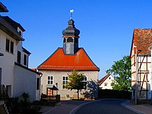
The Protestant church was built in 1746–54 and renovated in 1894 (building inscription). The unadorned, shingled half-timbered church with three axes shows a baroque hexagonal dome turret, which is rather rare in this form in Hesse . Until their own church was built, the Huguenots held their services in the hospital chapel in Treysa. Up until 1876, the service was mostly held in French.
Individual evidence
- ↑ Numbers / data / facts. In: website. City of Schwalmstadt, accessed August 2020 .
- ↑ Population figures on December 31, 2018. In: website. City of Schwalmstadt, accessed August 2020 .
- ↑ Construction of the Frankenhain motorway tunnel. Retrieved March 10, 2013 .
- ↑ First mentioned in 1297 and last mentioned in 1439.
- ↑ grouping of municipalities to the city "Schwalmstadt" County goat Hein of 7 January 1971 . In: The Hessian Minister of the Interior (ed.): State Gazette for the State of Hesse. 1971 No. 4 , p. 139 , point 158 ( online at the information system of the Hessian state parliament [PDF; 6.3 MB ]).
- ↑ main statute. (PDF; 314 kB) § 5. In: Website. City of Schwamstadt, accessed August 2020 .
literature
- Gable, Huguenot settlement, p. 67 ff
- Zögner, Huguenot Villages, in particular pp. 168–180 (plans)
- HOL Ziegenhain, p. 41 f.
- H. Cronjaeger, Treysa / Frankenhain In: “J. Desel, W. Mogk, Huguenots and Waldensians in Hessen-Kassel (1978) “= Monographia Hassiae 5, pp. 276–295
- Literature about Frankenhain in the Hessian Bibliography
Web links
- Frankenhain district. In: Website of the city of Schwalmstadt.
- Frankenhain. Local history, information. In: www.Frankenhain.info. Private website
- Homepage. Local history, information. In: www.frankenhain-hugenotten.de. Private website of the "Huguenot and History Association Frankenhain eV"
- Frankenhain, Schwalm-Eder district. Historical local dictionary for Hessen. In: Landesgeschichtliches Informationssystem Hessen (LAGIS).


