
Frauenland (Würzburg)
|
district of Würzburg |
|
|---|---|
  |
|
| Coordinates | 49 ° 47 '10 " N , 9 ° 57' 2" E |
| height | 203 m above sea level NHN |
| surface | 7.74 km² |
| Residents | 18,548 (Dec 31, 2008) |
| Population density | 2396 inhabitants / km² |
| Post Code | 97074 |
| prefix | 0931 |
| Transport links | |
| Federal road |
|
| railroad | Würzburg south |
| bus | 6, 10, 14, 16, 28, 29, 34, 114, 214 (not during the semester break) |
| Source: Würzburg.de | |
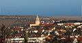
The Frauenland after the Old Town the most populous of the 13 districts of Würzburg , and includes the areas Mönchsberg Frauenland and Keesburg. The city district stretches to the east almost as far as Gerbrunn . To the west, the railway line borders the area to Sanderau and the old town and to Grombühl in the north. In the south, the Frauenland borders on the outskirts of Randersacker .
history
The name comes from the fact that a large part of the land on which the district later developed belonged to the women's monasteries until the secularization of 1803 . At the last stroke was the garden restaurant of the same name at Rottendorfer Strasse 29, where Richard Wagner frequented in 1833/34 when he was working as a choir director at the theater and composer in Würzburg. In 1836 there was almost nothing outside the city walls but a wagon factory; by 1900 the small strip east of the glacis and west of the railway line was already built on.
From 1880 the Würzburg Beautification Association created the Karolinenruhe Park between Rottendorfer Straße and Seinsheimstraße east of the railway line and south of the water reservoir , which was very popular because of its location near the city and has now given way to the Mittlerer Ring. To the west of today's Richard-Wagner-Strasse (not far from Letzen Hieb ) was the Velocipede Club's racing course.
By the 1930s, further residential complexes, the teacher training institute, the institute for the blind, the König-Ludwig-Haus clinic , the Mariannhiller Mission, the Medical Mission Institute and several churches were built .
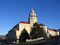
Around the 1930s, three architects in particular were active in Frauenland: According to plans by Albert Boßlet , the Church of Our Lady was built in 1936/37 (the parish of Our Lady in the new district of Frauenland was founded in 1941) and the Church of the Marianhiller Mission . During the National Socialist era, Hubert Groß created the garden city of Keesburg, residential buildings and the Berthold School (now the Goethe Elementary School) named after the fighter pilot hero Rudolf Berthold , and Peter Feile ( Neues Bauen ) some residential buildings.
In 1954, a housing area was built on Galgenberg, which solved the problem of confiscating living space in order to acquire housing in the destroyed Würzburg after the Second World War.
In 1970 only the area east of the Keesburg and the western slope of the Mönchberg were very sparsely developed.
The campus of the Julius Maximilians University of Würzburg was later built on the eastern edge, the so-called Hubland . Until 1977 there were only four exposed aggregate concrete structures, then more were added. In 2011, the building of the technical college south of the university campus was completed.
Frauenland has been one of the preferred residential areas in Würzburg since the 1920s, which is reflected in relatively high real estate prices.
Districts
Frauenland
This district of the same name as the city district is the largest of the three.
Here there are roughly residential houses in the western part and single-family houses in the eastern part. Three listed villas are located at Salvatorstrasse 12-16 .
There are also many buildings that are important for the social infrastructure and the two Christian churches of Our Lady ( Catholic ) and the Martin Luther Church (Protestant).
There are also several educational institutions in this district, including the Matthias-Grünewald-Gymnasium , the Dag-Hammarskjöld-Gymnasium, the Franz-Oberthür-Schule and the Goethe-Kepler-Grundschule. Also the branch of the University of Sociology, Political Science, Pedagogy and Special Education, popularly known as "PH" (University of Education). Up until 2009 there was a theater in the backyard that had not been used or was not used for a long time; in 2011 an extension with two lecture halls and a library was completed. At Hubland there are some other building complexes of the university, including a. with the university library and the computer center.
Keesburg
After the master mason Josef Kees († 1823) from Gaubüttelbrunn had lived in Würzburg for around ten years and had become prosperous, he built a country house in 1812 in the middle of his newly acquired lands southwest of the Galgenberg on the edge of the Würzburg district. The name Keesburg (formerly also incorrectly called Käsburg ), which today describes the entire garden city, came about because the buildings of the courtyard on the Neuberg looked like a castle from a distance. After 1927, the Hindenburgsiedlung, the core of today's garden city, was built around Gut Keesburg. At the end of 1950, the old manor and the vaulted cellar were demolished and replaced with the building that currently houses a Greek restaurant.
The small district of Keesburg is a garden city above the core city. Most houses fall into the row houses category .
The Würzburg public observatory is located in the Keesburg district , on the grounds of the Kepler school building of the Goethe-Kepler elementary school . The Free Waldorf School in Würzburg is also located there .
The local churches are the Church of the Resurrection (Protestant) and St. Alfons (Catholic).
Mönchberg
On the Mönchberg there is a monastery of the Mariannhiller missionaries , to which the Medical Mission Clinic and its important tropical medicine department are attached.
In the Mönchberg area, a branch chaplaincy was set up in 1921 , which received the Church of St. Barbara in 1926/27 . St. Barbara became its own parish in 1941.
There is also a Bundesbank branch and the Mönchbergschule, a primary and elementary school, which is characterized by special classes and offers for the integration of children with a migration background.
Another large building is the Wehrmacht on-site hospital, built in 1937, which was an American military hospital after the war and has been a residential complex since the beginning of 2010.
On the initiative of the Catholic Women's Association of Würzburg and Dompfarrer Braun, founded in 1904, an infant and children's home was built on Mönchberg in 1908, from which the children's clinic at Mönchberg later developed.
Leighton Barracks (geographic only)
The US armed forces maintained a large area here, the Leighton Barracks with residential complexes, schools, sports fields, a supermarket, a community center and a church. As part of the restructuring of the armed forces in Europe , the barracks were cleared and handed over to BIMA . Part of the site has been used by the University of Würzburg as the North Campus since May 2011 . The state horticultural show also took place on the former barracks grounds in 2018. With the conclusion of the state horticultural show, the newly planned Hubland district will be created here .
Picture gallery

Würzburg-Süd stop with regional train

University building on Wittelsbacherplatz

Parish Church of Our Lady

Martin Luther Church

University campus on Hubland (left: cafeteria; right: library)

Library on the university campus at Hubland

Typical little street in the Keesburg district

People's Observatory
Monastery of the Marianhiller Mission on Mönchberg
Exposed location of the monastery of the Marianhiller Mission on the Mönchberg


Web links
Individual evidence
- ↑ Stephanie Schwarz: Fairies and Wine. Richard Wagner. In: Kurt Illing (Ed.): In the footsteps of the poets in Würzburg. Self-published (print: Max Schimmel Verlag), Würzburg 1992, pp. 53-64; here: p. 62 f.
- ^ Sybille Grübel: Timeline of the history of the city from 1814-2006. In: Ulrich Wagner (Hrsg.): History of the city of Würzburg. 4 volumes, Volume I-III / 2, Theiss, Stuttgart 2001-2007; III / 1–2: From the transition to Bavaria to the 21st century. Volume 2, 2007, ISBN 978-3-8062-1478-9 , pp. 1225-1247; here: p. 1240.
- ↑ Klaus Witt City: church and state in the 20th century. In: Ulrich Wagner (Hrsg.): History of the city of Würzburg. 4 volumes, Volume I-III / 2, Theiss, Stuttgart 2001-2007; III / 1–2: From the transition to Bavaria to the 21st century. 2007, ISBN 978-3-8062-1478-9 , pp. 453–478 and 1304 f., Here: pp. 458–463: The era of the people's and resistance bishop Matthias Ehrenfried (1924–1948). P. 458.
- ↑ Rolf-Ulrich Kunze: Würzburg 1945-2004. Reconstruction, modern city. In: Ulrich Wagner (Hrsg.): History of the city of Würzburg. 4 volumes, Volume I-III / 2 (I: From the beginnings to the outbreak of the Peasant War. 2001, ISBN 3-8062-1465-4 ; II: From the Peasant War 1525 to the transition to the Kingdom of Bavaria 1814. 2004, ISBN 3 -8062-1477-8 ; III / 1–2: From the transition to Bavaria to the 21st century. 2007, ISBN 978-3-8062-1478-9 ), Theiss, Stuttgart 2001–2007, Volume III (2007), Pp. 318-346; here: p. 324.
- ^ Horst-Günter Wagner : The urban development of Würzburg 1814-2000. In: Ulrich Wagner (Hrsg.): History of the city of Würzburg. 4 volumes, Volume I-III / 2, Theiss, Stuttgart 2001-2007; III / 1–2: From the transition to Bavaria to the 21st century. 2007, ISBN 978-3-8062-1478-9 , pp. 396-426 and 1298-1302, here: pp. 420 f.
- ↑ Klaus Witt City: church and state in the 20th century. In: Ulrich Wagner (Hrsg.): History of the city of Würzburg. 4 volumes, Volume I-III / 2, Theiss, Stuttgart 2001-2007; III / 1–2: From the transition to Bavaria to the 21st century. 2007, ISBN 978-3-8062-1478-9 , pp. 453–478 and 1304 f., Here: pp. 458–463: The era of the people's and resistance bishop Matthias Ehrenfried (1924–1948). P. 458.
- ↑ Klaus Witt City: church and state in the 20th century. In: Ulrich Wagner (Hrsg.): History of the city of Würzburg. 4 volumes, Volume I-III / 2, Theiss, Stuttgart 2001-2007; III / 1–2: From the transition to Bavaria to the 21st century. 2007, ISBN 978-3-8062-1478-9 , pp. 453–478 and 1304 f., Here: pp. 455–458: The Church Development under Bishop Ferdinand Schlör (1898–1924). P. 456.

Old town | Dürrbachtal | Frauenland | Grombühl | Heidingsfeld | Heuchelhof | Lengfeld | Lindleinsmühle | Rottenbauer | Sanderau | Steinbachtal | Versbach | Zellerau