
Gaustadt
|
Gaustadt
City of Bamberg
Coordinates: 49 ° 54 ′ 16 ″ N , 10 ° 51 ′ 21 ″ E
|
|
|---|---|
| Height : | 244 m above sea level NN |
| Residents : | 6637 (Dec. 31, 2019) |
| Incorporation : | July 1, 1972 |
| Postcodes : | 96049, 96047 |
| Area code : | 0951 |

Gaustadt is located on the Regnitz and is a western district of the Upper Franconian city of Bamberg in Bavaria , Germany .
geography
To the west of Gaustadt lies Bischberg , to the north is Hallstadt and to the south the district is surrounded by the Michelsberg Forest, named after the Michelsberg monastery .
history
According to the necrology of the Michelsberg monastery, the founder of the so-called Erchanbrecht- or Erkenbertgut in Gaustadt was the priest Erkenbertus from the collegiate monastery St. Jakob Bamberg .
The collegiate monastery of St. Jakob was founded after the regests of the bishops and the cathedral chapter of Bamberg 1071-1072 under Bishop Hermann and was staffed with 25 canons . In the summer of 1072 the canons were removed and the place with all its affiliations was given to Abbot Egbert von St. Michael to introduce the monastic rule. This means that the foundation took place in 1071/1072 and that Gaustadt was first mentioned in a document. Erkenbertus was mentioned on March 22, 1087 as a participant in the synod of the Bamberg Church and as Canon of Bamberg. Pope Innocent IV confirmed the possessions of the Michelsberg Monastery in 1251, including Gaustadt.
On July 1, 1972, the then largest was municipality of the district of Bamberg , despite the einundneunzigprozentigen rejection by the people at a referendum as part of the municipal reform incorporated into the town of Bamberg.
The traditional center of Gaustadt was in the area around the St. Sebastian chapel and is still recognizable today by the small, winding streets in this area. At that time Gaustadt was surrounded by fields that belonged to the many Gaustadt farms. The local border to Bamberg was originally about one kilometer away from the actual place. As a result of the establishment of the ERBA on the municipal boundary of Bamberg towards the end of the 19th century, the demand for living space in Gaustadt rose sharply. So initially the area along the main street in the direction of Bamberg, characterized by the residential buildings of the factory building, developed very strongly. From the middle of the 20th century, the fields of the former farms, especially the Cherbonhof (formerly a large farm in the east of Gaustadt), were increasingly cultivated. The place initially spread in the area above today's parish church of St. Josef to the Michaelsberg forest in the south and the border with Bamberg in the east. The former fields, on which the town center is located today, can still be partially recognized by the street names (for example, the "Stammfeld" became the Stammfeldstrasse, the "Sturz" became the Sturzstrasse and the "Höhe" became the Höhenstrasse). The west was opened up by building the area around the so-called "Eichhorn" west of the Sylvanersee.
Today the transition from Gaustadt to Bamberg is smooth, the town limit can only be recognized by the town sign at the end of Gaustadt main street. The last major new development areas in Gaustadt were the eco-settlement below the Bamberger Weg and the settlement on Ochsenanger. Since the end of the state horticultural show, new residential units have been built in the brick building and on the site of the former ERBA. Another large new building area is being built on the site of the former brickworks, above the Gaustadter cemetery. The former municipal area of Gaustadt is now largely developed through residential development and only a few vacant lots are left. In order to meet the consistently high demand for living space, there were recently considerations about a new residential area between Rothofer Weg and Ziegelhüttenweg south of Vogtstrasse and Krötleinstrasse.
Population development
|
|
|
|
|
As a result of the development boost in the planning for the State Garden Show 2012 and the subsequent residential development and university settlement on the ERBA island (this new district of Gaustadt had 893 inhabitants on December 31, 2019), the number of inhabitants increased again from 2011 onwards. As of December 31, 2019, Gaustadt had its highest population in history.
Economy and Infrastructure
With the establishment of the mechanical cotton spinning and weaving mill in Bamberg in 1858, colloquially known as “Spinnerei”, later also called “ERBA” ( Erlangen- Bamberg), the appearance of the rural Gaustadt and the life of its residents changed forever. The original monastery village developed rapidly into an industrial and workers' community. With the bankruptcy of ERBA AG in 1993/1994, Gaustadt lost its largest employer and its economic importance in the region. The Nordpark was built on the industrial site, where the Bamberg State Horticultural Show took place in 2012 . Before the 2012/13 winter semester, the Faculty of Business Informatics and Applied Computer Science at the Otto Friedrich University of Bamberg moved into its new location on the ERBA island.
The largest employers currently in Gaustadt are the company Rudolf Zimmermann, Bamberg GmbH , which produces all kinds of lights, with around 350 and the Kaiserdom brewery with around 60 employees.
Gaustadt experienced further changes and revitalization in the late 1980s and early 1990s through the development and development of the Cherbonhof district with eco-settlements .
politics
Mayor from 1945 to 1972:
- Anton Krug ( SPD ) 1945–1946
- Johann Jäck ( CSU ) 1946–1952
- Peter Habermann ( Free Voters ) 1952–1960
- Kilian Krug (CSU) 1960–1966
- Andreas Stenglein (SPD) 1966–1972
Attractions

Parish Church of St. Joseph
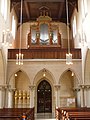
Organ of the parish church

Chapel of St. Sebastian
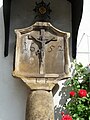
Pestmarter with the year at the St. Sebastian chapel


- Parish church of St. Josef, built 1899–1906 with neo-Gothic furnishings
- Fischerhof, recreation center for the monks of the Michelsberg monastery in Bamberg
- St. Sebastian Chapel, built in 1808 as the first new church in Northern Bavaria after secularization
- Pestmarter
- Cherbonhof (owned by the nobles von Weling and their descendants from 1820 )
- War memorial, 1922 by Hans Leitherer , Bamberg (with A. Seidlein)
religion
- The Roman Catholic parish of St. Josef, with regular church services by the Portuguese Mission in Nuremberg, has approx. 3920 Catholics with primary residence and, together with the parish of St. Martin in the city center and St. Josef im Hain, forms the pastoral care area of St. Martin and St. Josef Bamberg.
- The Evangelical Lutheran Church of St. Matthew was consecrated in 1964. It stands on land that was given to the community by the Wörner family.
- The Ukrainian Greek Catholic staff parish of St. Nikolaus has been using the former old people's home chapel for the dioceses of Bamberg and Würzburg since 2000 .
- In addition, regular church services by the Russian Orthodox Church in Nuremberg take place in Gaustadt .
societies
sports clubs
- ASV Gaustadt: football , gymnastics , Nordic walking
- DJK Teutonia Gaustadt: football, gymnastics, aerobics , skiing , triathlon , table tennis
- Vaulting Association eV
- Reitverein Hippo Plus eV: Riding
- Zimmerstutzen and small bore rifle club 1899 Gaustadt: Air rifle , air pistol , Zimmerstutzen , small bore shooting
- ASG Hofer Bamberg-Gaustadt 1897 e. V .: Air rifle, crossbow and small-caliber shooting
- RKB Solidarity Gaustadt: bike ball , figure skating
- Sportkegelclub Gaustadt: bowling
music
- Liederhort 1874 Gaustadt eV
- Gaustadt men's choir
- Marching band St. Josef Gaustadt eV
Others
- Bürgererverein Gaustadt eV
- Obst- und Gartenbauverein Gaustadt eV
- Friends of the Gaustadter Freibad eV (Friends of the outdoor swimming pool)
- Kleingartenverein Gaustadt eV
- Associacao Recreativa Portugeusa eV (Association of the Portuguese Community)
- Ortscaritasverein Gaustadt St. Josef eV
- KDFB - Branch Association Gaustadt (Catholic German women's association)
- KJG - local group Gaustadt
Personalities
Sons and daughters of the place
- Rudolf Groß (1888–1954), German crystallographer, mineralogist and university professor
- Andreas Sebastian Stenglein (* 1929), German politician (SPD)
Personalities who have worked in the place
- Klaus Zachert (1942–2011), German local and state politician (SPD), vice-principal at the Bamberg-Gaustadt elementary school
Gaustadter picture stones

The three Bamberg idols (Gaustadter Götzen, more correctly: Gaustadter Bildsteine ) were recovered in 1858 from the alluvial sand of the Regnitz near Gaustadt.
These are sculptures made of Keuper sandstone, which was deposited in the Obermaing area in geological prehistory . They are about 1 to 1.70 m tall. Their age is unknown; it can range from the Neolithic to the first millennium AD. As a result, the figures can be interpreted as pagan idols or as early Christian creations.
Individual evidence
- ^ Wilhelm Volkert (ed.): Handbook of Bavarian offices, communities and courts 1799–1980 . CH Beck'sche Verlagsbuchhandlung, Munich 1983, ISBN 3-406-09669-7 . Page 600
literature
- Konrad Arneth: Gaustadt. A Franconian monastery village. Wilhelm Schramm printing works, Hallstadt 1972
- Andreas Sebastian Stenglein: Gaustadt, first mention of the place. Bamberg, 2006
- Ingrid Weidner: Noodles for everyone. The “Cherbonhof” eco-settlement in Bamberg is twenty years old - its concept is still relevant today . In: Süddeutsche Zeitung , September 5, 2008.
Web links
- Andreas Stenglein Researches and publications on the history of Gaustadt
- Bürgererverein Gaustadt eV Extensive treatises on the history of Gaustadt

Bruckertshof | Bug | Bughof | Garden city | Gaustadt | Deer knock | Kramersfeld | Wildensorg