Border between Liechtenstein and Austria
The border between Liechtenstein and Austria is around 35 kilometers (35,040 meters) long. It separates the state of Vorarlberg in the Republic of Austria from the territory of the Principality of Liechtenstein . The current border line has been legally binding since July 20, 1960 in a bilateral state treaty on the course of the common state border.
Borderline
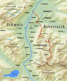
The common border between Liechtenstein and Austria begins in the north in the triangle between Austria, Liechtenstein and Switzerland. This point is located right in the middle of the Rhine near the Austrian village of Bangs , a district of the city of Feldkirch . The three-country point also represents the westernmost point of the Austrian national territory and the northernmost and deepest point of the Liechtenstein national territory. From here, the state border follows in long sections of smaller drainage ditches (such as the Frickgraben ) through the Bangser and Ruggeller Riet to the southeast. Then the border reaches the steep ascent to Eschnerberg , where the Zollstrasse between the villages of Fresch (A) and Hinterer Schellenberg (FL) is crossed. The border follows the Eschnerberg on its ridge (at the highest point 698 m above sea level ) to the south and reaches the densely built-up and merging settlement area of the villages of Tosters (A) and Mauren (FL) on both sides of the border . Here, in the middle of the residential area, is the Binsen border crossing . The further course of the border leads again through Riedlandschaft and the Egelsee to the most important border crossing between Austria and Liechtenstein near Tisis (A).
From the local area of Tisis, the further border line leaves the heavily populated Rhine Valley and continues to rise in a south-easterly direction into mountainous terrain. From this section on, the Rätikon mountains form the natural border between the two states, with some peaks being crossed by the border in the further course. For example, the Mistelmark , a peak that marks the border between the municipal areas of Feldkirch and Frastanz on the Austrian side , is crossed. Then the state border turns to the Sarojahöhe , reaches the summit of the Three Sisters and those of the Garsellakopf and the Garsella towers . The border crosses the Saminatal and Gamperdonatal and finally reaches at its southernmost point, the 2571 m above sea level. A. (or 2570 m above sea level ) high Naafkopf again a three-country point with Switzerland. This border point marks the southern end of the common border between Austria and Liechtenstein.
Municipalities on the state border are (from north to south):
|
LIECHTENSTEIN |
AUSTRIA |
|||||||
|---|---|---|---|---|---|---|---|---|
| Constituency | local community | Border crossing |
Border crossing |
local community | district | state | ||
| Switzerland | ||||||||
| Unterland |
|
|
|
Feldkirch |
Vorarlberg |
|||
|
|
||||||||
|
|
|
|||||||
| A l p e n |
||||||||
|
|
||||||||
|
|
||||||||
| Oberland |
|
|||||||
|
|
||||||||
|
|
||||||||
|
|
||||||||
|
|
Bludenz | |||||||
|
|
||||||||
|
|
||||||||
|
|
||||||||
| Switzerland | ||||||||
Border crossing and border traffic
In Alpenrheintal there are currently four direct border crossings for private transport between Liechtenstein and Austria. The border line south of Tisis, which is mainly located in high alpine terrain, no longer allows cross-border motorized individual traffic. The most important Austro-Liechtenstein border crossing is between Tisis , a district of the Austrian city of Feldkirch , and Schaanwald , a district of the Liechtenstein municipality of Mauren . This is the only border crossing at which the customs procedures for the import and export of goods between Austria and Liechtenstein are processed - freight traffic is therefore only permitted via this border crossing. On the Austrian side, Landesstraße 191a, known as Liechtensteiner Straße , leads to the border crossing , and on the Liechtenstein side, Feldkircher Straße, which is the main road through Liechtenstein.
There is also a rail link between Feldkirch and Mauren as part of the Feldkirch – Buchs line operated by the Austrian Federal Railways . There are three stops for regional trains on the territory of Liechtenstein, before the railway line leaves the territory after crossing the Rhine after just under nine kilometers. The railway line is regularly used by Austrian regional trains from Feldkirch station , and international long-distance trains - such as the ÖBB connection from Vienna to Zurich - also run over the route.
Both the Republic of Austria, which is an EU member state , and the Principality of Liechtenstein have joined the Schengen Agreement , which is why there are no longer any identity checks at the border crossings between the two countries. Until Liechtenstein joined the Schengen Agreement on December 19, 2011, the common border was Austria's last remaining external Schengen border, after Switzerland had already joined the Schengen Agreement in December 2008. Similar to the border between Austria and Switzerland, there are still customs controls at the border crossings between Austria and Liechtenstein. On the Liechtenstein side, these are not carried out by the Liechtenstein authorities, but by the Swiss Border Guard on the basis of a contract with Switzerland .
Border between Liechtenstein and the German Reich (1938–1945)
Until September 1939, the border between Liechtenstein and the former Austria, which had been part of the German Reich as "Ostmark" since 1938, was not secured. That's why hundreds of refugees managed to cross the border during this time. The border crossing points were subsequently secured with barbed wire and Spanish horsemen . At the beginning of 1940 the construction of a two meter high barbed wire fence began. The fence, which stretched 14 kilometers from Älpele via Tisis, Tosters and Nofels to the Rhine and thus covered almost the entire border in the Rhine Valley, was raised by another half a meter in 1942. After this increase, only a few border crossings were counted.
As a result of Austria's annexation to the German Reich, border protection units of the German customs took over the surveillance of the border. These consisted of a core group from Germany and supplementary staff consisting of local men. These locals were called "Higo" (auxiliary border workers) throughout the war, although their official designation from 1940 onwards was auxiliary customs assistant. The Higo took over most of the guards in the border area and received training in shooting, terrain, platoon and combat. From 1942 many Higo were drafted into the Wehrmacht. Older men took over their jobs, including many World War I veterans. On the Liechtenstein side, the Liechtenstein national police and the auxiliary police reinforced the Swiss border guard responsible. Members of the Swiss army were not deployed at the border, although the Liechtenstein government had asked the Swiss government to do so. The Swiss government rejected this because of Switzerland's neutrality.
From the border dispute on the Sareiserjoch to the State Treaty
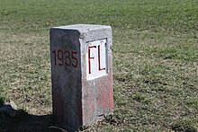
After the Second World War and Austria's liberation from National Socialism , the French occupation authorities carried out a border inspection with representatives of the Austrian municipality of Frastanz and Liechtenstein in the Samina Valley , during which it was agreed to set new boundary stones. This became necessary because previously existing boundary signs had become unrecognizable or lost. After the Vorarlberg state government showed little understanding for this unauthorized action by the occupation authorities, an extensive first inspection to set the new boundary stones in 1947 with the participation of representatives of the state government revealed that an area of around 24 hectares in the Gamperdona valley below the Sareiserjoch was controversial. In the Austrian land register of 1856/57, this area was recorded as Austrian national territory, but Liechtenstein objected that it had never officially confirmed this definition of the boundary. These were essentially properties on the Liechtenstein Alp Sareis , which would have been located a few hectares on Austrian territory.
In 1950, the Principality of Liechtenstein offered the Republic of Austria 10,000 francs if the latter had completely and irrevocably waived the disputed territorial claims on the Sareiserjoch. The Vorarlberg state government informed the Ministry of the Interior, however, that they refused such a "sale of state territory" and recommended the Ministry in July 1950 to let an arbitration court decide on the issue. On a map of the country's territory published by Liechtenstein in 1952, the disputed area was entirely ascribed to Liechtenstein. Before there could be formal proceedings before an international arbitration tribunal, for the establishment of which the draft contracts had already been submitted, the dispute was settled by a small commission within the framework of another non-binding inspection. Austria was assigned two triangular parts of the Liechtenstein Alp Sareis, advancing towards Gamperdona, the rest was assured to Liechtenstein. On March 17, 1960, the State Treaty on the establishment of the state border and the maintenance of the boundary signs was finally signed in Vaduz, which finally put an end to the border dispute on the Sareiserjoch. This state treaty on the common national border has been constitutional in Austria since 1964 ( Federal Law Gazette No. 59/1964 , Art II. Z 9).
See also
literature
- Ferdinand Waibel: The Treaty between the Republic of Austria and the Principality of Liechtenstein from 1931 . In: Internationale Rheinregulierung Rohrschach (Ed.): The Alpine Rhine and its regulation. International Rhine Regulation 1892–1992. 2nd Edition. BuchsDruck, Buchs 1993, ISBN 3-905222-65-5 , p. 193-196 .
- Peter Geiger: Liechtenstein's relations with Vorarlberg and Feldkirch in the Second World War . In: Rheticus Society (ed.): Series of publications by the Rheticus Society . tape 55 . Feldkirch 2012, ISBN 978-3-902601-31-5 , p. 23-44 .
- Ulrich Nachbaur : Vorarlberger Territorialfragen 1945 to 1948. A contribution to the history of the Vorarlberg state borders since 1805 (= Vorarlberger Landesarchiv [Hrsg.]: Research on the history of Vorarlbergs . Volume 8 (NF)). UVK Verlagsgesellschaft , Konstanz 2007, ISBN 978-3-89669-629-8 (available as PDF at Academia.edu ).
Web links
Individual evidence
- ↑ Treaty between the Republic of Austria and the Principality of Liechtenstein to determine the state border and maintenance of the frontier character of 20 July 1960 at the Legal Information System of the Republic of Austria .
- ↑ Gerd Zitzelsberger: Liechtenstein-Switzerland border: 40 kilometers security gap . Article on Süddeutsche.de from May 17, 2010.
- ^ Gerhard Wanner: Refugees and Borderline Conditions in Vorarlberg 1938 - 1944 . In: Quarterly magazine of the Rheticus Society . Issue 3/4. Feldkirch 1998, p. 227–271 ( available online at Remember.at [PDF]).
- ↑ a b Ulrich Nachbaur : Vorarlberg territorial questions between 1945 and 1948. A contribution to the history of Vorarlberg borders since 1805 (= Vorarlbergs archive [Ed.]: Research on the history of Vorarlberg . Band 8 (NF)). UVK Verlagsgesellschaft , Konstanz 2007, ISBN 978-3-89669-629-8 , chapter 12.3. Border dispute at the Sareiserjoch: Determination of the federal and state border with Liechtenstein , p. 247–251 (available as PDF at Academia.edu ).
- ↑ Peter Bußjäger : "Will Vorarlberg call the UN?" In: Vorarlberg Chamber of Commerce (ed.): Subject Vorarlberg . Edition 54, December 2019, ZDB -ID 2798381-X , p. 32 ( available online at themavorarlberg.at).


