Great Fürstenseer See
| Great Fürstenseer See | ||
|---|---|---|

|
||
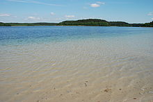
| Großer Fürstenseer See from the outskirts in Fürstensee | ||
| Geographical location | District of Mecklenburg Lake District | |
| Tributaries | Small anthropogenic tributaries from the Großer Schmarssee and Plasterinsee | |
| Drain | Small anthropogenic outflows to Tiefen Trebbower See and into the Zwirnsee | |
| Places on the shore | Fürstensee | |
| Location close to the shore | Neustrelitz | |
| Data | ||
| Coordinates | 53 ° 18 '17 " N , 13 ° 9' 50" E | |
|
|
||
| Altitude above sea level | 63.4 m above sea level NHN | |
| surface | 2.04 km² | |
| length | 2.08 km | |
| width | 1.42 km | |
| volume | 13.6 million m³ | |
| scope | 12.8 km | |
| Maximum depth | 24.5 m | |
| Middle deep | 6.7 m | |
| Catchment area | 39.1 km² | |
Geography / topography
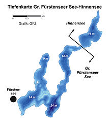
The Großer Fürstenseer See is located in the east of the Müritz National Park , about four kilometers southeast of Neustrelitz ( Mecklenburg Lake District ). To the north, the UNESCO World Heritage Site "Old Beech Forests around Serrahn" borders the lake. It is divided into two elongated parts by a narrow peninsula, the Pankower Ort, which run as parallel channels in a north-south direction and are connected in the south by a larger lake area. The lake has a total water area of 252 hectares. The large basin of the Großer Fürstenseer See is connected to the smaller Hinnensee in the northeast by a narrowing around 50 meters wide and two meters deep. The mean water depth of the Großer Fürstenseer See is 6.7 meters, with the maximum depth in the south of the main basin being 24.5 meters.
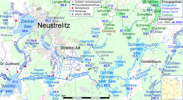
The lake, which is predominantly fed by groundwater and rainwater, has two smaller anthropogenic tributaries from the Plasterinsee and the Großer Schmarssee . The lake has two drains in the form of the raft ditch to the Tiefen Trebbower See and another ditch to the Zwirnsee . The lake can be classified as a flowing lake according to the hydrological lake classification. As a mesotrophic lake with high aquatic biodiversity and very good water quality, it is of particular importance for nature and water protection, tourism and science.
geology
The Great Fürstenseer See is a glacial lake ( Rinnensee ) created by the effects of the inland ice and its meltwater . The lake is completely embedded in a sander , which in its northern part borders on the main terminal moraine of the Pomeranian ice edge of the Vistula glacial . As a result of drilling in neighboring lakes and moors, it can be assumed that the Großer Fürstenseer See was also formed by dead ice rafts in the Late Pleistocene- Early Holocene. A flat to shallow undulating environmental relief with a multitude of smaller and larger dead ice caves dominates around the lake, with the exception of the northern part of the lake, where the relative height difference is about 50 meters over a short distance (surrounding heights up to 116 meters above sea level). A multitude of limnic relief forms such as terraces , beach ridges and fossilized steep banks form the shore of the lake.
Limnology
Today, the Große Fürstenseer See lies in the course of the approximately 20 km long raft ditch that rises east of Carpin and first flows through the Schweingartensee and the Lutowsee . The current drainage route was only created in 1932. Before that, it ran north through Zwirnsee and Schäferei-Pöhle to Jägerpohl . Its water level is not noted in older measuring table sheets, but must have been lower than today's 64.9 (DTK10) or 64.6 (lake cadastre) m above sea level. NHN. The old drainage route has been a tributary since 1990.
The networking of the region's lakes, which had previously been isolated inland catchment areas, took place in connection with the construction of water mills. It is believed to have started in the 13th century. However, the first documented mention was the Domjüchmühle in 1636. The network through ditches made the Großer Fürstensee “from a groundwater lake with a relatively small catchment area into a flowing lake with a relatively large catchment area.” This change is also used to explain archaeologically proven very high water levels.
The following information can be found for the water level of the Großer Fürstenseer See: According to two measuring table sheets from 1888 it was 64.2 m, after the analog TK100 from 1996 it was 63.6 m. The same value is given in the MV Seenkataster as a long-term mean. The current DTK is 63.2 above sea level. NHN .
From the effluent of the Great Lake Fürstenseer for 5½ km from the depths of Lake Trebbower the Floßgraben crosses a polder glände where he water from a pumping station receives. After 9.5 km of flow from the exit point it flows into the Woblitzsee of the Havel .
In the catchment area of the Großer Fürstenseer See, a distinction is made between a larger above-ground (39.5 km²) and a smaller underground (approx. 20 km²) catchment area. The direction of groundwater flow in the area runs from northeast to southwest. This means that the groundwater flows move in the same direction as the surface waters, which is not a matter of course in the terminal moraine wall of the Pomeranian glaciation .

The Großer Fürstenseer See has an opening to the Hinnensee two meters deep and twenty meters wide . The mean residence time in water is 5.4 years. The pH of the lake is around 8 and the conditions are weakly alkaline . The deepest point of the Großer Fürstenseer See-Hinnesees is thermally stable in summer. High visibility depths of a maximum of 8.1 meters and the proven low biomass production, as well as the high depth gradient and the morphometry mean that the lake can be classified as mesotrophic .
climate
In terms of climate, the lake is located in an area with an oceanic-continental transition situation. According to data from the neighboring Neustrelitz climate station of the German Meteorological Service, the mean annual temperature is eight ° C and the mean annual precipitation is 584 mm (reference period 1961–1990).
flora
Underwater vegetation
The nutrient content of the water and the concentration of the plankton are decisive for the clarity of the Großer Fürstenseer See and thus also the range of species of its underwater plants. Of particular importance is the large-scale occurrence of is stoneworts (Characeae) in the lake. These algae are mainly found in lime-rich, nutrient-poor waters. While there are up to 20 species in the Großer Fürstenseer See (lower macrophyte limit at 9 meters), only five species can be found in the Hinnensee (lower macrophyte limit at 6 meters).
Surrounding vegetation
The area around the lake is characterized by deciduous forests (beeches, oaks) in the north and coniferous forests (pines) in the south.
fauna
fishes
Common fish species in the Fürstenseer See are pike ( Esox lucius ), European eel ( Anguilla anguilla ), lead ( Abramis brama ), river perch ( Perca fluviatilis ), ruff ( Gymnocephalus cernua ), roach ( Rutilus rutilus ), rudd ( Scardinius erythierophthalmus ) and Schlehrierophthalmus ( Tinca tinca ). Particularly noteworthy is the occurrence of the whitefish ( Coregonus albula ). Vendace ( Coregonus ) is a salmon fish and is found in clear, deep and oxygen-rich lakes.
Birds
The water bird life on the lake Fürstenseer consists mainly of Bleßralle ( Fulica atra ), mallard ( Anas platyrhynchos ) and grebes ( Podiceps cristatus ) together, also comes Goldeneye ( Bucephala clangula ) ago. In the reed beds on the banks area live small birds such as ponds and reed warbler ( Acrocephalus scirpaceus, A. arundinaceus ) Reed Bunting ( Emberiza schoeniclus ) and Kingfisher ( Alcedo atthis ). The bittern ( Botaurus stellaris ) can also be found in the bank area.
Due to the location of the Fürstenseer See in the middle of the Müritz National Park with its extensive forests, the lake offers an excellent habitat for lake ( Haliaetus albicilla ) and osprey ( Pandion haliaetus ).
Mammals
Mammals bound to the waters in the area are the otter ( Lutra lutra ) and the European beaver ( Castor fiber ). The largest mammal, the red deer ( Cervus elaphus ), lives in the surrounding forests . Recently (2012, 2013) the wolf ( Carnis lupus ) was detected.
history
Settlement history
The area around the lake has been inhabited by man since at least the Middle Stone Age. Since the Neolithic Age , humans have been changing the vegetation and water balance of the region through their land use (agriculture, cattle breeding). The village of Fürstensee was first mentioned in a document in 1283. Since the Middle Ages , the increasing demand for timber, firewood, charcoal and tar has changed the forest. With the introduction of regulated forest management , forests were re-established by means of large-scale pine plantings since the 18th century and used as a monoculture for several generations of forests . Parts of the lake catchment area have near-natural forests that have been used primarily for hunting for around 200 years.
tourism
The lake has several bathing areas, including one in the village of Fürstensee and one on the south-east bank of the lake. For reasons of nature conservation, the use of the lake by motor sport boats and diving with breathing apparatus is not permitted. Fishing is restricted.
Science and research
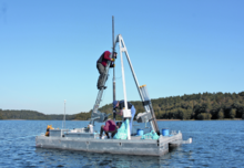
In the Great Fürstenseer See, limnological research, especially the study of underwater vegetation, has so far been the focus. Since 2010, the lake and its catchment area have been intensively investigated as part of the Helmholtz Association's two research projects, "TERENO Nord-Ost" and "ICLEA", by the German Research Center for Geosciences and in close cooperation with the Müritz National Park Office . Among other things, research on hydrology, dendrochronology and the history of the lake and water balance is carried out. Scientific goals are the monitoring and analysis of changing environmental conditions as a result of global change .
Popular science, fiction and photography
The lake has already been the subject of popular science, fiction and photographic publications several times.
The book Serrahn World Natural Heritage in the Müritz National Park by Hans-Jürgen Spieß and Peter Wernicke provides information on the origin of the area, but also on the flora and fauna in and around the Großer Fürstenseer See .
The author Marco Lehmbeck wrote about his childhood experiences, most of which take place at the Großer Fürstenseer See and in his hometown Neustrelitz. In the course of a literary award from the Annalize Wagner Foundation, his short story Familie im Kahn was honored.
In the photo book Müritz National Park. Homage to a landscape by Sandra Bartocha and Peter Wernicke, the seasons are reflected in the national park. The Fürstenseer See is mentioned here. Lars Hoffmann also shows in The Mecklenburg Lake District. Water / land / light aerial photographs and landscape panoramas of the lake.
See also
literature
- S. Bartocha, Peter Wernicke : Müritz National Park. Homage to a landscape . Edition Morizaner, 2010, ISBN 978-3-941803-01-5 .
- O. Bens, M. Schwank, T. Blume, A. Brauer, A. Güntner, I. Heinrich, G. Helle, S. Itzerott, K. Kaiser, T. Sachs, RF Hüttl: TERENO - a monitoring and research platform to record the long-term effects of global change on a regional level. In: System Earth - GFZ-Journal. Volume 2, No. 1, 2012, pp. 68–73 ( PDF; 670 kB )
- T. Blume, S. Krause, K. Meinikmann, J. Lewandowski: Upscaling lacustrine groundwater discharge rates by fiber-optic distributed temperature sensing. In: Water Resources Research. No. 49, 2013, pp. 7929-7944.
- R. Doll: The vegetation of the Great Fürstenseer See in the Neustrelitz district. In: Gleditschia. No. 10, 1983, pp. 241-267.
- M. Gebel: Limnological investigations on the Großer Fürstenseer See / Hinnensee with special consideration of the macrophyte vegetation. Thesis. Saarland University, Saarbrücken 1994.
- L. Hoffmann: Water / Land / Light. The Mecklenburg Lake District. Edition Morizaner, Röbel / Müritz 2009, ISBN 978-3-941803-00-8 .
- K. Kaiser, S. Germer, M. Küster, S. Lorenz, P. Stüve, O. Bens: Lake level fluctuations in northeast Germany: observation and reconstruction. In: System Earth - GFZ-Journal. Volume 2, No. 1, 2012a, pp. 62–67 ( PDF; 862 kB )
- K. Kaiser, J. Friedrich, S. Oldorff, S. Germer, R. Mauersberger, M. Natkhin, M. Hupfer, P. Pingel, J. Schönfelder, V. Spicher, P. Stüve, F. Vedder, O. Bens, O. Mietz, RF Hüttl: Current hydrological changes in lakes in northeast Germany: water level trends, ecological consequences, possible courses of action. In: U. Grünewald, O. Bens, H. Fischer, RF Hüttl, K. Kaiser, A. Knierim (eds.): Water-related adaptation measures to landscape and climate change . Schweizerbart, Stuttgart 2012, ISBN 978-3-510-65274-7 , pp. 148-170.
- K. Kaiser, S. Lorenz, S. Germer, O. Juschus, M. Küster, J. Libra, O. Bens, RF Hüttl: Late Quaternary evolution of rivers, lakes and peatlands in northeast Germany reflecting past climatic and human impact - an overview. In: E&G Quaternary Science Journal. No. 61, 2012, pp. 103-132.
- HD Knapp, U. Voigtländer, L. Grundmann, (Hrsg.): The Müritz area: results of the regional studies in the area goods, Klink, Federow. In: Values of the German homeland. No. 60, Böhlau, Weimar 1999.
- H.-J. Prillwitz: Chronicle of the place Fürstensee 1283-2008 . Neustrelitz 2008.
- H.-J. Spieß, P. Wernicke: Serrahn - World Natural Heritage in the Müritz National Park . Natur + Text, Rangsdorf 2013, ISBN 978-3-942062-07-7 .
- H.-J. Spieß: Results of the investigation of submerged macrophytes in mesotrophic-eutrophic lakes in Mecklenburg-Western Pomerania. In: Rostock marine biology contributions. No. 13, 2004, pp. 73-84. ( PDF; 418 kB ( Memento from February 1, 2014 in the Internet Archive ))
Web links
- Müritz National Park
- Article on planeterde.de
- TERENO north-east
- Video from the Großer Fürstenseer See
Individual evidence
- ↑ a b c d e f g h Ministry for Agriculture, Environment and Consumer Protection Mecklenburg-Western Pomerania: Lake Program . 2012. Written communication.
- ↑ Mauersberger: Classification of the lakes for the natural space exploration of the northeast German lowlands ( Memento of the original from April 13, 2016 in the Internet Archive ) Info: The archive link was automatically inserted and not yet checked. Please check the original and archive link according to the instructions and then remove this notice. . 2006, pp. 51-89.
- ↑ Knut Kaiser, Janek Dreibrodt, Mathias Küster & Peter Stüve: The hydrological development of the Großer Fürstenseer See (Müritz National Park) - An overview in New contributions to natural space and the history of the landscape in the Serrahn sub-area of the Müritz National Park (PDF) , p. 61 ff.
- ^ Kaiser et al.: Water-related adaptation measures to landscape and climate change . 2012, pp. 148-170.
- ↑ Knapp among other things: The Müritz area: results of the regional history inventory in the area Waren, Klink, Federow . 1999.
- ^ German Weather Service: Climate + Environment: Average values for 30-year periods . Retrieved January 29, 2014.
- ↑ Prillwitz: Chronicle of the place Fürstensee 1283-2008 . 2008.
- ^ Doll: The vegetation of the Great Fürstenseer See in the Neustrelitz district . 1983.
- ↑ Gebel: Limnological investigations on the Großer Fürstenseer See / Hinnensee with special consideration of the macrophyte vegetation . 1994.
- ↑ Spieß et al: Serrahn - World Natural Heritage in the Müritz National Park . 2004.
- ↑ German Research Center for Geosciences: TERENO - Terrestrial Environmental Observatories ( Memento of the original from October 4, 2013 in the Internet Archive ) Info: The archive link was inserted automatically and has not yet been checked. Please check the original and archive link according to the instructions and then remove this notice. . Retrieved January 29, 2014.
- ↑ ICELA: ICLEA - Virtual Institute for Integrated Climate and Landscape Development Analysis . Retrieved January 29, 2014.
- ↑ Spieß et al: Serrahn - World Natural Heritage in the Müritz National Park. 2013.
- ^ Lehmbeck: Family in the summer in the boat. A short story. In: Carolinum - historical-literary magazine. No. 74, 2010, pp. 49-51.
- ↑ Bartocha among others: Müritz National Park. Homage to a landscape . 2010.
- ^ Hoffmann: Water / Land / Light. The Mecklenburg Lake District. 2009.


