
Köneürgenç
| Köneürgenç | |||
|---|---|---|---|
| Куня-Ургенч | |||
| State : |
|
||
| Province : | Thatşoguz welaýaty | ||
| Coordinates : | 42 ° 20 ' N , 59 ° 9' E | ||
| Residents : | 31,565 (2005) | ||
|
|||

Köneürgenç , in German Köneürgentsch ( Russian Кёнеургенч Kjoneurgentsch ; also Куня-Ургенч Kunja-Urgentsch ), is a city on the edge of the Karakum desert and near the border with Uzbekistan in the extreme north of the Turkmen province of Daşoguz (as of January 1, 2005 with 31,565 inhabitants ). It was only in the 19th century at the 2005 UNESCO - World Heritage declared ruins of the old Khwarazmian capital Gurgandsch (like the newer city of Urgench also Gurgentsch or Gurgānǧ written) built.
Surname
"Köneürgenç", the (today) official, Turkmen name of the city, is the modern, Turkish form of the earlier, Persian name "Kuhna Urgandsch" (کهنه اورگانج; DMG Kuhna Ūrgānǧ), which translated means "Old Urganj". "Urganj" or "Urgantsch" (Urganč) is the Turkish form of " Gurganj" (Urganč), which has been used around the time of Mongol rule.گرگانج, DMG Gurgānǧ ), the original name of the city (i.e. in use until the Mongol storms ). The "old" only serves to distinguish the capital, which was abandoned in the 17th century, from another chorzmic city of the same name, which was only built in the modern era and today belongs to Uzbekistan (article on this city: Urganch ). Also derived from the Persian "Gurgandsch" is "al-Jurdschaniya" (الجرجانية, DMG al-Ǧurǧānīya ), the Arabic name of the city.
history
antiquity
Ceramic finds from the so-called "Kyrk Molla" (see sights), which is probably the oldest settlement core, suggest that the history of the city goes back to at least the 5th century BC. BC, so in Achaemenid times, but so far very little is known about the pre-Islamic Gurganj, in which some see the "Urva" mentioned in the Avesta . In the annals of the early and late Han dynasties ( Han Shu and Hòu Hàn Shū ) it is possibly mentioned under the name "Yue-kien". Traces of the 4th to 3rd century BC BC can be found in the nearby Dev-Kesken .
Early Islamic period

After the conquest of Choresm by the Muslim Arabs (712), it seems that Gurganj, which had risen to a rich trading city thanks to its contacts in the northern Caspian region (southern Russia / Eastern Europe ) and its connection to the Silk Road , and the old regional center of Kath where the Afrighids , ruling over Choresm since 305, resided, to have developed an economic and political rivalry. ( Gardizi even speaks of an “ancient enmity” in his work “Zain al-aḫbār ”). In the 10th century, when Khorezm was temporarily under the rule of the Samanids and the caliphate envoy Ibn Fadlān stayed in Gurganj for three months before he could continue his journey to the Volga Bulgarians (together with 3000 camels and 5000 companions) , this rivalry had then apparently the country was divided into two competing spheres of power, which was only overcome when the Emir of Gurganj, Mamun (d. 997), conquered Kath in 995, the Afrighids, overthrowing the Mamunid dynasty, and as the new Khorezm Shah relocated the Chorzmic capital to Gurganj.
Capital of the Khorezm Shahs
While Kath gradually lost its importance (and shrank considerably), the new capital Gurganj, which the Arabs counted among the three largest cities of Khorezm as early as the 8th century, according to al-Maqdisi "from day to day". The city, connected to the Amudarja by water channels , had four gates and two palaces, one of which, Mamun I (Maʾmūn ibn Muḥammad), had particularly magnificent portals and the other was owned by Mamun's son and successor ʿAlī ibn Maʾmūn (died 1009) was built. Ali, under whom the Khorezm Shahs were again completely independent, also had a large square built in front of the city gates where sheep were sold, and Maʾmūn ibn Maʾmūn or Ma'mun II. (Died 1017) is (thanks an inscription) is known as the builder of a minaret , the remains of which are still visible today (see section on sights). Under the latter Shah, who, like his vizier Ahmad al-Suhaili, met with such famous scholars as al-Bīrūnī , Ibn Sina (known in the West as Avicenna ), Abu Sahl al-Masihi , Abu Nasr al-Arraq , Abu l-Chair al -Hasan ibn al-Kammar and Abu Mansur Abd al-Malik ath-Thalibi , the brief rule of the Mamunids then reached its climax and Gurganj developed into one of the most brilliant centers of Islamic civilization .
However, this cultural bloom and the award of Mamun II. With titles and gifts by the caliph aroused the envy of Sultan Mahmud of Ghazna (d. 1030), which was associated with plans for conquest , who ultimately asked Mamun to bring the most outstanding scholars to his own court (after Ghazna ) and thus to recognize the supremacy of the Ghasnavids over Khorezm. The Shah then had no choice but to submit to the sultan, who had risen to become the most powerful ruler of the Islamic East, but this led to a revolt of the Choresmians, which led to Mamun being killed and Mahmud consequently having a welcome reason to join Choresm To occupy the year 1017 and to put an end to the rule of the Mamunids. The Khorezm Shahs from the Altuntaschid dynasty (1017-1041) and a large number of Seljuk governors (from 1042/43) resided in Gurganj, before a dynasty came to power in the 12th century with the Anushteginids of Turkish origin Rule, the city was to become one of the largest and most magnificent in the entire Orient.
As the imperial capital of the powerful Khorezm Shahs from the Anushteginid dynasty, who ruled almost the entire east of the Islamic world, Gurganj benefited of course (like all of Khorezm) from the extensive income (tributes, spoils of war ...) that the Shahs' conquests brought with them, and grew into a prosperous metropolis, which, according to the geographer and traveler Yaqut (d. 1229) , who stayed in Khoresm in 1219/20, could not match any city in the world in wealth, population or size of its residence (after all, Yakut already had Syria , Egypt and Iraq and Khorasan traveled). At the Anuschteginidenhof, where the rulers subjugated by the Shahs or their children who were held hostage lived and had to take part in the court ceremonies, numerous brilliant artists and scholars once again met, including the doctor Zain ad-Din Ismail ibn Husain Dschurdschani ( d. 1136/37), the philologist and Koran exegete Zamachschari (d. 1144) and the writer Raschid ad-Din Vatvat (d. 1182/83) should be mentioned. Impressive monuments such as the stylistically interesting tombs of Il-Arslan and Tekisch (see section on sights) were erected and, with their typical choresm design, influenced not only the architecture of Iran and today's Afghanistan , but also that of the Sultanate of Delhi and the Mughal Empire . Unfortunately, almost nothing remains of this glory of the “pearl choresms”, since Genghis-Chan , who reunited all the troops specially for the purpose of taking the well-fortified metropolis, had Gurganj razed to the ground in 1221: after the residents of their city for a long time Defended bitterly (probably for a few months) and forced the Mongols to conquer each quarter individually with heavy losses, Genghis- khan ordered the dam that protected Gurganj from the Amu Darya to be destroyed, so that the city was already completely devastated and partly burning was also flooded and even the last remaining buildings sank in the floods. The few inhabitants (hiding or playing dead) who had not previously been driven out of the conquered city were also killed in order to either be killed immediately by the Mongols or (if they were artists or craftsmen) selected for deportation . The latter fate overtook more than 100,000 residents; all in all, hundreds of thousands are said to have died in the conquest of Gurganj - described as particularly terrible in all contemporary sources.
After the Mongol storm
Rebuilt (1231), Urgench (as Gurgandj was now mostly called) then initially belonged to the empire of the Golden Horde and once again developed into a flourishing metropolis that the traveler Ibn Battūta (d. 1368 or 1377) visited during his visit (1333). as the greatest, most beautiful and most important of the Turks. The monuments of the city mentioned by Ibn Battuta that still stand today include, for example, the tomb of the great Sufi master Nadschm ad-Din Kubra , who was killed in the Mongol storm, and the mausoleum of Tura-Beg-Chanum, whose husband, Qutlugh-Timur , as Governor Ösbek-Chans also had the minaret named after him (and which can still be seen today) restored (see section on sights). As the residence of the (Turkish) Sufids , Urgench was once again the capital of an independent ruling dynasty since the 1360s, but this last heyday ended with the complete destruction of the city by the armies of Temür (d. 1405) in 1388, from which the city separated should never fully recover. Only partially rebuilt (1391), Urgench lost its former economic and cultural importance and was finally abandoned and abandoned in the 17th century after the rule of the Golden Horde, the Timurids , the Shaibanids and the Safavids in the 16th century followed the Arabshahids and Khiva in the south of Khorezm had risen to the new center of the country. At that time, not far from Khiva, the already mentioned New Urgench, which today belongs to Uzbekistan, was built, which, unlike Old Urgench, never achieved any special importance. In the middle of the 19th century, before Khorezm fell to the Russian Empire in 1873 , the modern Köneürgenç was founded, which has belonged to the Republic of Turkmenistan since 1924.
Attractions
The ruins of Gurganj, which have still not been adequately explored, were named a World Heritage Site by UNESCO in 2005 - which fulfills criteria (ii) and (iii) - which confirms that they are unique testimonies to Choresm's highly developed Islamic culture and supra-regionally influential Architectural tradition.
The most important monuments include:
- Kyrk Molla
- The approximately 3 ha covering a maximum of 12 m high and partially walled hill of the "40 Mullahs " (translation by Kyrk Molla) contains, among other things, the remains of a fortress - which is probably the oldest settlement center in Gurganj - and was later used as a cemetery.
- Mamun II minaret
- 1900 Find a lead plate with a kufic inscription, which, in addition to the client Mamun II., Also dates back to 401 d. H. (= 1010/1011) calls. It must have collapsed between 1885 and 1899 (after the first destruction by the Mongols and a possible reconstruction in the 14th century). During a first scientific investigation by Tolstov in 1952, the foundation (up to a marble ring) could still be seen (in addition, the sparse remains of the associated mosque were discovered at that time). Reconstruction 1999–2000 up to a height of 6 m.
- " Il-Arslan -Mausoleum"
- Quite small, brick-built tomb from the 12th century with a square base and an elaborately ornamented entrance facade, on which there is also a calligraphic inscription (crowning 3 decorated niches). It has a high domed roof in the form of a dodecagonal pyramid, the outer brick layer of which is partially glazed in turquoise blue and thus forms a kind of zigzag / diamond pattern. Assignment uncertain, since it is actually much too modest for a ruler like Il-Arslan (but also the often used designation as the grave of the philosopher Fachr ad-Din Razi cannot be correct, since he was buried in Herat ).
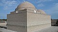
- Tekisch Mausoleum
- Tomb made of bricks with a square base, which was one of the very few buildings of the Anuschteginid period to withstand the catastrophe of 1221 to some extent. The high, splendid domed roof, the outer brick layer of which is partially glazed in turquoise blue and thus forms a geometric pattern, has a conical shape and is provided with an elegant tape at the base. The simplicity of the substructure, the only decoration of which is the muqarnas decor above the entrance, is probably explained by the fact that the building was not originally free-standing, but rather part of a larger grave complex.
- The "gate of the caravanserai "
- (Today) a single, elaborately decorated portal made of bricks, which was certainly not a simple "caravan gate", as it is much too magnificent for that, probably dates from the time of the Anuschteginid rule (12th / 13th centuries). The archway inside is decorated with beautiful (dark blue-white-turquoise) mosaics, which form geometric and floral patterns. It was excavated by Tolstov in 1952 and restored in the 1980s and 1999-2000.
- Nadschm-ad-Din-Kubra mausoleum
- The 14th century tomb with a portal decorated with blue, green and white tiles has four domes and a central interior with two decorated cenotaphs.
- Qutlugh Timur Minaret
- The minaret, which probably dates back to a damaged previous building from the time before the Mongol storm and was only restored by Choresm's governor Qutlugh-Timur in the 14th century, is (still today) 62 meters, the highest in Central Asia. The diameter is 12 m at the base and 2 m at the top (accessible via a 143-step spiral staircase). The outer layer of brick (occasionally glazed in blue) partially forms patterns and bears bands of inscriptions.
- Tura Beg Chanum Mausoleum
- Tomb mosque from the 14th century, which is generally attributed to Qutlugh-Timur's wife Tura-Beg-Chanum, but probably served as a mausoleum of the Sufid dynasty (which ruled a little later). It has a 21 m high and 14 m wide portal and a dome decorated inside with geometric patterns reminiscent of the starry sky, which crowns an approximately 100 m² hexagonal interior and was once covered with blue tiles on the outside.
- Sultan Ali mausoleum
- A relatively unadorned, unfinished domed building from the 15th or 16th century, which stands directly opposite the grave of Nadschm ad-Din-Kubra and imitates the Tura-Beg-Chanum mausoleum.
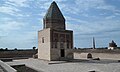
"Il-Arslan-Mausoleum" (on the right in the background the Qutlugh-Timur-Minaret and the Tekisch-Mausoleum)

“Il Arslan Mausoleum” portal view
Grave in "Il Arslan Mausoleum"

Sultan-Tekisch-Mausoleum (on the right in the background the "Il-Arslan-Mausoleum")
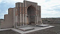
"Gate of the Caravanserai"

Qutlugh Timur Minaret (on the right in the background the Tekisch Mausoleum)

Qutlugh Timur Minaret and Sayyid Ahmad Mausoleum (behind the Tekish Mausoleum)

Sayyid Ahmad Mausoleum (front view)
Sayyid Ahmad Mausoleum (rear view)

Tura Beg Chanum Mausoleum
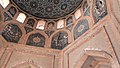
Tura Beg Chanum Mausoleum (interior view)


See also
Sources, literature and web links
- Guy Le Strange: The Lands of the Eastern Caliphate - Mesopotamia, Persia and Central Asia from the Moslem Conquest to the Time of Timur , Cambridge University Press, 1930
- Clifford Edmund Bosworth : Articles "GURGĀNḎJ" and "KH w ĀRAZM" in: Encyclopaedia of Islam , New Edition (ed. By PJ Bearman et al.), Leiden 1960–2004
- Wilhelm Barthold : Turkestan down to the Mongol invasion (EJW Gibb Memorial Series), London 1928 (pp. 144–146, 185, 275 ff.)
- Sergei Pawlowitsch Tolstow : In the footsteps of the ancient Choresm culture , Berlin 1953 (p. 246 f., 253 ff.)
- Information on the most important monuments on ArchNet
- Information and pictures about “Urgench” on karakalpak.com
- Entry on the UNESCO World Heritage Center website ( English and French ).

Heritage: Ruins of Merw (1999) | Köneürgenç (2005) | Parthian fortresses of Nisa (2007)