Hatillo de Loba
| Hatillo de Loba | ||
|---|---|---|
|
Coordinates: 8 ° 57 ' N , 74 ° 5' W Hatillo de Loba on the map of Colombia
|
||
|
Location of the municipality of Hatillo de Loba on the map of Bolívar
|
||
| Basic data | ||
| Country | Colombia | |
| Department | Bolívar | |
| City foundation | 1637 | |
| Residents | 12,270 (2019) | |
| City insignia | ||
| Detailed data | ||
| surface | 426 km 2 | |
| Population density | 29 people / km 2 | |
| height | 18 m | |
| Waters | Río Magdalena , Brazo de Loba , Brazo de Mompós | |
| Time zone | UTC -5 | |
| City Presidency | Maryolis Isabín González Amaris (2016–2019) | |
| Website | ||
| The Río Magdalena at Hatillo de Loba | ||
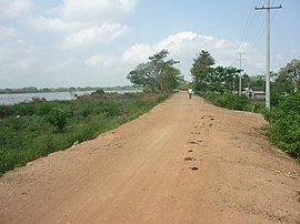
| Country road at Hatillo de Loba | ||
Hatillo de Loba is a municipality ( municipio ) in Colombia in the department of Bolívar .
geography
Hatillo de Loba is located in the south of Bolívar between the Brazo de Loba and Brazo de Mompós arms of the Río Magdalena in the east of Isla Margarita in the sub-region of Depresión Momposina Bolivarense , 360 km south of Cartagena . The annual average temperature is 30 ° C.
Hatillo de Loba borders in the north on the Brazo de Loba and the municipality of Margarita and San Fernando , in the east on El Banco in the Departamento del Magdalena and El Peñón , in the south on the municipalities of Barranco de Loba and San Martín de Loba and in the west the municipality of Pinillos .
Hatillo de Loba also includes the rural parts of the municipality ( corregimientos ) La Victoria, Juana Sánchez, La Ribona, San Miguel and El Pozón.
population
The municipality of Hatillo de Loba has 12,270 inhabitants, of which 3661 live in the urban part (cabecera municipal) of the municipality (as of 2019).
history
Before the arrival of the Spaniards, the area of today's Hatillo de Loba was inhabited by the indigenous peoples of the Malibues and the Chimilas. During the colonial period, the area was first populated by poor settlers and runaway slaves. The then mayor of Mompós , Diego Ortiz Nieto, carried out successful expeditions against runaway slaves and in return received the Loba area from the government in 1637, to which the present-day Hatillo also belongs. The municipality of Hatillo de Loba was founded in 1988 by outsourcing from the municipalities of San Martín de Loba and Barranco de Loba .
economy
The main industries of Hatillo de Loba are fishing and pond farming (even if the water quality has declined in recent years) as well as timber and mining .
Web links
- Alcaldía Municipal de Hatillo de Loba, Bolívar. Alcaldía de Hatillo de Loba - Bolívar, accessed on May 21, 2019 (Spanish, website of the municipality of Hatillo de Loba).
Individual evidence
- ↑ Geography. Alcaldía de Hatillo de Loba - Bolívar, accessed on May 21, 2019 (Spanish, information on the geography of the municipality).
- ↑ ESTIMACIONES DE POBLACIÓN 1985 - 2005 Y PROYECCIONES DE POBLACIÓN 2005 - 2020 TOTAL DEPARTAMENTAL POR ÁREA. (Excel; 1.72 MB) DANE, May 11, 2011, accessed on May 21, 2019 (Spanish, extrapolation of the population of Colombia).
- ↑ Reseña Historica. Alcaldía de Hatillo de Loba - Bolívar, accessed on May 21, 2019 (Spanish, information on the history of the municipality).
- ↑ Information on the economy on the official website of Hatillo de Loba ( page no longer available , search in web archives )


