Howard County, Maryland
 Howard County Courthouse |
|
| administration | |
|---|---|
| US state : | Maryland |
| Administrative headquarters : | Ellicott City |
| Foundation : | 1838 |
| Made up from: | Anne Arundel County |
| Area code : | 001 410 |
| Demographics | |
| Residents : | 287,085 (2010) |
| Population density : | 439.6 inhabitants / km 2 |
| geography | |
| Total area : | 657 km² |
| Water surface : | 4 km² |
| map | |
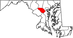
The Howard County is a county in the US state of Maryland . The county seat is Ellicott City .
geography
| growth of population | |||
|---|---|---|---|
| Census | Residents | ± in% | |
| 1860 | 13,338 | - | |
| 1870 | 14,150 | 6.1% | |
| 1880 | 16,140 | 14.1% | |
| 1890 | 16,269 | 0.8% | |
| 1900 | 16,715 | 2.7% | |
| 1910 | 16,106 | -3.6% | |
| 1920 | 15,826 | -1.7% | |
| 1930 | 16,169 | 2.2% | |
| 1940 | 17,175 | 6.2% | |
| 1950 | 23,119 | 34.6% | |
| 1960 | 36,152 | 56.4% | |
| 1970 | 61,911 | 71.3% | |
| 1980 | 118,572 | 91.5% | |
| 1990 | 187,328 | 58% | |
| 2000 | 247,842 | 32.3% | |
| 2010 | 287.085 | 15.8% | |
| before 1900 1900–1990 2000 + 2010 | |||
The county is about halfway between Baltimore and Washington, DC and covers an area of 657 square kilometers; of which four square kilometers (0.60 percent) are water. It borders on the following counties:
| Frederick County | Carroll County | Baltimore County |
| Montgomery County |

|
|
| Prince George's County |
Anne Arundel County |
history
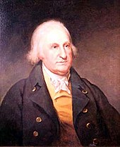
Howard County was formed in 1851 from part of Anne Arundel County. It was named after John Eager Howard (1752-1827), the first governor of Maryland (1788-1791).
Four Howard County sites have National Historic Landmark status due to their historical significance . 36 buildings and sites in the county are listed on the National Register of Historic Places (as of November 14, 2017).
Demographic data
According to the 2010 census , Howard County had 287,085 people in 98,994 households. The population density was 439.6 inhabitants per square kilometer.
The racial the population was composed of 62.2 percent white, 17.5 percent African American, 0.3 percent Native American, 14.4 percent Asian and other ethnic groups; 3.6 percent were descended from two or more races. Regardless of ethnicity, 5.8 percent of the population was Hispanic or Latino of any race. In the 98,994 households there were statistically 2.73 people each.
25.8 percent of the population were under 18 years old, 64.0 percent were between 19 and 64 and 10.2 percent were 65 years or older. 50.7 percent of the population was female.
The median income for a household in the 101,417 USD . The per capita income was $ 44,120. 4.5 percent of the population lived below the poverty line.
cities and communes
Census-designated places
In Howard County there are no independent communities ( incorporated communities ), since the settlements are practically only suburbs of the city of Baltimore. However, these are not legally part of the city. Because of their size, the United States Census Bureau has created a number of census-designated places (CDP):
1 - partially in Anne Arundel County
Unincorporated Communities
All other settlements in the county are neither independent communities nor CDPs, but rather unincorporated communities :
1 - partly in Anne Arundel County
2 - partly in Carroll County
3 - partly in Carroll and Baltimore Counties
Individual evidence
- ↑ GNIS-ID: 1709077. Retrieved on February 22, 2011 (English).
- ^ University of Virginia Library - Historical Census Browser. Retrieved August 21, 2011
- ↑ United States Census.gov.Retrieved August 21, 2011
- ↑ Excerpt from census.gov (2000 + 2010) ( Memento of the original from July 11, 2011 on WebCite ) Info: The archive link was inserted automatically and has not yet been checked. Please check the original and archive link according to the instructions and then remove this notice. Retrieved April 4, 2012
- ↑ Listing of National Historic Landmarks by State: Maryland . National Park Service , accessed November 14, 2017.
- ↑ Search mask database in the National Register Information System. National Park Service , accessed November 14, 2017.
- ↑ US Census Bureau, State & County QuickFacts - Howard County ( Memento of the original from July 11, 2011 on WebCite ) Info: The archive link was automatically inserted and not yet checked. Please check the original and archive link according to the instructions and then remove this notice. Retrieved August 21, 2011
Web links
- US Census Bureau, State & County QuickFacts - Howard County
- Yahoo Image Search - Howard County
- www.city-data.com - Howard County
Coordinates: 39 ° 15 ′ N , 76 ° 56 ′ W


