Harford County
 Harford County Courthouse |
|
| administration | |
|---|---|
| US state : | Maryland |
| Administrative headquarters : | Bel Air |
| Address of the administrative headquarters: |
Harford County Government 212 South Bond Street Bel Air, MD 21014 |
| Foundation : | 1773 |
| Made up from: | Baltimore County |
| Area code : | 001 410 |
| Demographics | |
| Residents : | 244,826 (2010) |
| Population density : | 208.7 inhabitants / km 2 |
| geography | |
| Total area : | 1364 km² |
| Water surface : | 191 km² |
| map | |
| Website : www.harfordcountymd.gov | |
The Harford County is a county in the US state of Maryland . The county seat is Bel Air .
Harford County is part of the metropolitan area around the city of Baltimore , which is southwest of the county.
geography
Harford County is separated from Pennsylvania to the north by the Mason-Dixon Line . To the southeast it borders the northwest coast of Chesapeake Bay . Harford County covers an area of 1,364 square kilometers; 191 square kilometers (16.4 percent) of it is water. It borders on the following counties:
|
York County, Pennsylvania |
Lancaster County, Pennsylvania |
|
| Baltimore County |

|
Cecil County |
| Kent County 1 |
1 - Maritime limit in Chesapeake Bay
history
Harford County was formed in 1773 from parts of Baltimore County. It was named after Henry Harford (1758–1834), the fifth and last Lord Proprietor of Maryland (1771–1776), who was awarded this title as a child.
Due to its historical significance, a residential building has the status of a National Historic Landmark , the Sion Hill . 79 buildings and sites in the county are listed on the National Register of Historic Places (as of November 14, 2017).
Demographic data
| growth of population | |||
|---|---|---|---|
| Census | Residents | ± in% | |
| 1790 | 14,976 | - | |
| 1800 | 19,626 | 31% | |
| 1810 | 21,258 | 8.3% | |
| 1820 | 15,924 | -25.1% | |
| 1830 | 16,319 | 2.5% | |
| 1840 | 17,120 | 4.9% | |
| 1850 | 19,356 | 13.1% | |
| 1860 | 23,415 | 21% | |
| 1870 | 22.605 | -3.5% | |
| 1880 | 28,042 | 24.1% | |
| 1890 | 28,993 | 3.4% | |
| 1900 | 28,269 | -2.5% | |
| 1910 | 27,965 | -1.1% | |
| 1920 | 29,291 | 4.7% | |
| 1930 | 31,603 | 7.9% | |
| 1940 | 35,060 | 10.9% | |
| 1950 | 51,782 | 47.7% | |
| 1960 | 76,722 | 48.2% | |
| 1970 | 115.378 | 50.4% | |
| 1980 | 145.930 | 26.5% | |
| 1990 | 182.132 | 24.8% | |
| 2000 | 218,590 | 20% | |
| 2010 | 244,826 | 12% | |
| before 1900 1900–1990 2000 + 2010 | |||
According to the 2000 census , Harford County had 218,590 people in 79,667 households and 60,387 families. The population density was 496 people per square kilometer. The racial the population was composed of 86.8 percent white, 9.3 percent African American, 0.2 percent Native American, 1.5 percent Asian and 0.8 percent from other ethnic groups; 1.5 percent were descended from two or more races. Hispanic or Latino of any race was 1.9 percent of the population.
Of the 79,667 households, 38.7 percent had children under the age of 18 living with them. 61.9 percent were married couples living together, 10.2 percent were single mothers, and 24.2 percent were non-families. 19.7 percent of all households were single households and 6.8 percent had people aged 65 or over. The average household size was 2.72 and the average family size was 3.14.
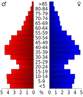
27.9 percent of the population was under 18 years old, 6.8 percent between 18 and 24, 31.6 percent between 25 and 44, 23.7 percent between 45 and 64 years old, and 10.1 percent were 65 years or older . The median age was 36 years. Statistically, there were 96.0 males for every 100 females and 92.5 males for every 100 females aged 18 or over.
The average income of a household amounted to 57,234 USD , for a family is 63,868 USD. Males had a median income of $ 43,612 versus $ 30,741 for females. The per capita income was $ 24,232. About 3.6 percent of families and 4.9 percent of the population lived below the poverty line .
cities and communes
Census-designated places (CDP)
Individual evidence
- ↑ GNIS-ID: 1698178. Retrieved on February 22, 2011 (English).
- ↑ Listing of National Historic Landmarks by State: Maryland . National Park Service , accessed November 14, 2017.
- ↑ Search mask database in the National Register Information System. National Park Service , accessed November 14, 2017.
- ^ University of Virginia Library - Historical Census Browser. Retrieved August 5, 2011
- ↑ United States Census.gov.Retrieved August 5, 2011
- ↑ Excerpt from census.gov (2000 + 2010) ( Memento of the original from July 11, 2011 on WebCite ) Info: The archive link was inserted automatically and has not yet been checked. Please check the original and archive link according to the instructions and then remove this notice. Retrieved April 4, 2012
- ↑ Harford County, Maryland 2000 census data sheet at factfinder.census.gov
Web links
- Harford County Office of Economic Development
- Maryland State Archives - Harford County
- www.city-data.com - Harford County
Coordinates: 39 ° 32 ′ N , 76 ° 18 ′ W


