Ile de Noirmoutier
| Ile de Noirmoutier | ||
|---|---|---|
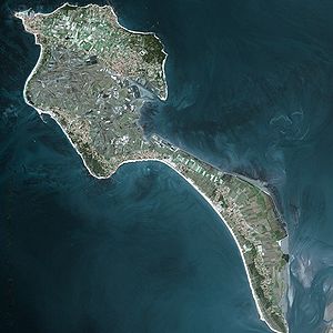
| Satellite image of the Île de Noirmoutier | ||
| Waters | Atlantic Ocean | |
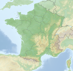
| Geographical location | 47 ° 0 ′ N , 2 ° 16 ′ W | |
|
|
||
| length | 20 km | |
| surface | 48.8 km² | |
| Highest elevation | (unnamed) 20 m |
|
| Residents | 9592 | |
| main place | Noirmoutier-en-l'Île | |
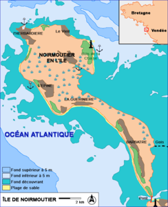
| Map of the island | ||
The Île de Noirmoutier is a French Atlantic island that belongs to the Pays de la Loire region in western France, is located south of the Loire estuary near Fromentine and has almost 10,000 inhabitants. Half of them live in the main town of Noirmoutier-en-l'Île .
A geographical peculiarity of the 48.8 km² large and 20 kilometers long tidal island ( French Île-de-marée ) is the fact that a large part of its area is below sea level . It is fairly flat, but has a rocky coast in the north. When the tide is low , the island can be reached on foot or by road vehicle. The 4½ kilometer long paved street Passage du Gois , on the edges of which mussels are sought in the season , is a tourist attraction . Warning signs indicate the times when it is passable. In addition, there are rescue and observation towers at close intervals along the roadside, from which the area can be viewed. The extensive salt marshes with numerous rare and protected plants in the lowlands are important for nature conservation . Large dunes - and rocky coastal areas in the north - shape the appearance of the Noirmoutier. In winter, the island is home to hundreds of thousands of sea birds and waders that overwinter there.
etymology
When Saint Philbert founded a monastery on the island in the 7th century , it was called Île d'Her or Île d'Herio, but this does not necessarily mean that the origin of the current name Her-Moutier (coming from Heri Monasterium) was. Because there is no written document about it. Much more likely a derivation of Neir-Moustier (from a document from the 14th century), which is a translation of the name Nigrum Monasteriums , i.e. Black Monastery in Old French.
During the reign of terror of the French Revolution, the island was called "Île de la Montagne", the main town of Noirmoutier was called "Port-Victoire".
geography
Geographical location
Noirmoutier is an island in the Atlantic; it is located in the northern part of the Biscay , south of the Loire estuary . It is in front of the French mainland and only a few hundred meters away from it. Between it and the mainland lies a shallow bay, the Baie de Bourgneuf .
geology
The island consists of three parts:
- a rocky area in the north, which was originally called "Insel Her", and where the main town of Noirmoutier-en-l'Île is also located
- a strip of dunes in the southern and eastern area
- the "salt marshes" emerged from the former swamp and floodplain between these two parts
The island of Her was formed in the early Quaternary when part of the mainland plate subsided , which also resulted in the Baie de Bourgneuf bay . The dune strips later formed in the current "shadow" of Her.
There are also two polders ( Kooge ) that were created by dikes in the 18th and 19th centuries.
To the northwest of Noirmoutier is the small island of Île du Pilier .
climate
Noirmoutier has a Mediterranean climate with mild summers (so-called climate type Csb according to the effective climate classification ). The number of hours of sunshine is also large at 2100 and comparable z. B. with the corresponding value of Carcassonne . In the period 1971-2000 the maximum temperature was 37 ° C, it was reached twice in 1990 and once in 2003. The lowest measured temperature was −10 ° C and was measured in January 1985. The average annual temperature during this period was 12.8 ° C. As a result of the mild climate, plants that are otherwise more associated with the Mediterranean region also grow there, such as B. Mimosa and strawberry trees .
history
prehistory
Various relics testify to human settlement as early as prehistory :
- Tool finds from the Mesolithic are around 10,000 years old and were found in the Bois de la Chaize.
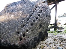
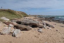
- Remains of megaliths such as menhirs and dolmens date from the Neolithic Age , such as the Dolmen de la Table in the Bay of Bourgneuf or the Dolmen de la Pointe de l'Herbaudière in the far north-west, also known as the Dolmen of Noirmoutier or the Menhir des Dames. In the Bois de la Chaize there is a quarry from which stones come that were used in Commequiers , 50 km away , to build a dolmen.
At the end of the 19th century, two dolmens could still be admired near l'Herbaudière. Of the five menhirs that still existed at the time, only the stele in the Bois de la Chaize near the wooden landing stage is available.
antiquity
The island was still inhabited, as evidenced by the remains of a Roman villa with thermal baths found near the village of Le Vieil. From the excavation finds it is concluded that the villa dates from the 2nd and 3rd centuries AD.
middle Ages
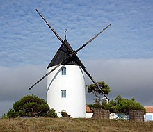
The Holy Philibert founded around 674 a Benedictine monastery and encouraged to till the soil, the population to gain salt and build windmills. Due to the exposed location near the shore, the population often suffered from attacks by the Saracens (around 730) and later, in the 9th century, by the Loire-Normans . Around 830 the monastery was reinforced with a castrum . The castle was rebuilt in the 12th century after being destroyed many times. In the years 1342, 1360 and 1388/1390, i.e. after the Hundred Years' War , the English tried to gain a foothold here. At times the monks and part of the population left the island.
In the Middle Ages, feudal lords were initially the lords of La Garnache and later the La Trémoille family ; In the 16th and 17th centuries, individual members even carried the title of Baron of Noirmoutier or Duke of Noirmoutier. The coat of arms of Noirmoutier-en-l'Île is identical to that of the Trémoille family.
Modern times
In the middle of the 16th century there were raids by Protestant privateers . B. in 1562 the abbey "Abbaye de la Blanche" and destroyed the salt harvest. Attacks by the Spaniards in 1524 and 1588 were repulsed. The Dutch landed in 1674 under the leadership of their admiral Cornelis Tromp , they looted and even kidnapped church bells from Noirmoutier. The population could only buy their way out of the occupation by paying a ransom.
The Prince de Condé finally sold the island to King Louis XV in 1767 .
French Revolution and the Vendée Wars
First the French Revolution and the subsequent Vendée uprisings brought great unrest and destruction . In January 1794 a part of the republican western army succeeded in conquering the island held by the insurgents. For the promise to lay down their arms and not fight against the Republicans any more, they received an assurance in return that nothing would happen to them. They retreated partly to the fortress of Noirmoutier and partly to the church of Noirmoutier. Other prisoners, including women and children, were taken to the church. After all, there were up to 1,500 people there. From the following day onwards, they were led away in small groups of 60 people and some were killed on the beach and some in the city. Among the prisoners was the former commander of the insurgents, Maurice Joseph Louis Gigost d'Elbée . He was shot in the main square in Noirmoutier.
Boom in the 19th century
There was a slow development in the 19th century: The places Barbâtre, La Guerinière and l'Epine were elevated to independent political communities. Independent parishes also emerged in Barbâtre, L'Epine and Herbaudière. In the second half of the century tourism slowly started. Early visitors included U. the painters Henri Rousseau and Auguste Renoir , who stayed here with his family in 1892 and made two paintings during his stay.
Noirmoutier in World War II
After the island was occupied by the German Wehrmacht , access was strictly controlled, because Noirmoutier was barely more than 20 kilometers away from the mouth of the Loire and thus from Saint-Nazaire and the German submarine base there. Every person who wanted to leave the island or wanted to go there needed a pass.
The west coast in particular, facing the open sea, was heavily fortified with gun emplacements. There were a total of eleven defensive posts, the largest of which was the gun emplacement on La Guerinière beach. From here, the island's Atlantic coast could be monitored and, if necessary, shot at. This position, called Tirpitz, consisted of eleven fortified structures: a command post , two machine gun positions and four bunkers, each equipped with a 7.5 cm cannon. Two of these also had a 2 cm gun for anti-aircraft defense .
The importance that the Germans attached to the island is evidenced by the fact that Field Marshal Rommel also visited the island of Noirmoutier during one of his inspections of the West Wall in 1943.
The marine anti-aircraft department 811 was used on the Ile de Noirmoutier and was under the command of the island Noirmoutier. It was divided into a battery stick and six Flak - batteries and was moved in 1943 to Brest. The light naval artillery division 684 was set up on Noirmoutier in April 1942 with seven companies and was subordinate to the sea commander Loire . In August 1944 it was placed under the La Rochelle Fortress . In July 1943, a US B 17 bomber had to land in the bay of La Guerinière after being hit by German flak and German aircraft. The ten-man crew survived the emergency landing and were captured by German troops. In August 1944, Allied aircraft sank four German minesweepers type M 40 in the strait between Noirmoutier and the mainland in Fromentine .
In September 1944, the island was evacuated by the Wehrmacht without a fight and 351 soldiers with eight 7.5 cm field cannons and five 4.7 cm PAK were transferred to La Rochelle.
population
Population development
Between 1968 and 2009 the population grew from approx. 8,000 people to 9,700. This corresponds to an overall increase of over 20%. This increase is solely due to the influx from the mainland, because the number of births has been lower than the number of deaths for years. 27% of the population are older than 65 years.
religion
The majority of the islanders belong to the Roman Catholic religion . Since 1997 they have been grouped together in the parish of St Philbert en Noirmoutier. The smaller parishes of Barbâtre, which were probably founded as early as the 11th century and whose existence was attested in writing in 1385, and the parishes of L'Epine (1807), La Guérinière (1839) and L'Herbaudière (1876), which were established in the 19th century dissolved.
The parish on Noirmoutier, together with the parishes of Saint Martin des Monts (in St Jean-de-Monts ), Notre-Dame du Gois (in Beauvoir sur Mer ), and Saint Amand de l'île d'Yeu, form the deanery of Saint Jean-de -Monts and belong to the Diocese of Luçon .
Economy and Infrastructure
tourism
The tourism forms, with around 120,000 visitors per year, the economic basis for most residents. Around 2/3 of all apartments are second homes for holidays. But many are only used for a few weeks a year. A total of 18,000 beds are available to tourists. There are 19 hotels and nine campsites . The main travel season is the holiday months of July and August: during this period, almost 1 million vehicles crossed the bridge to the mainland and almost 200,000 vehicles used the Passage du Gois (as of 2010).
There are smaller in l'Herbaudière (northwest corner) and l'Epine marinas . For many years there was a passenger ferry connection to Pornic during the main season , but this was discontinued in 2009.
Fishing
Fishing and fish farming , oyster farming and mussel farming are important pillars of the economy:
In 2010, 1600 tons of fish were landed in the port of Herbaudière. 1800 t of oysters and 500 t of mussels were marketed in 2010. There is also a France-Turbot farm based on Noirmoutier, which can bring up to 500 t of turbot onto the market every year.
Salt extraction
Salt production also plays an important role . The salt marshes in particular have a long tradition; the first were created by the monks in the 7th and 8th centuries by draining the swamps. Today they cover almost a third of the island. In the Middle Ages, the Baie de Bourgneuf was the destination of the so-called Baienfahrt of the Hanseatic League due to salt extraction .
Noirmoutier is the third largest salt producer in France: 2,700 tons of common sea salt are extracted every year, as well as 140 tons of the famous “Fleur de Sel”. Most of the salt is sold through a cooperative . The annual turnover in 2010 was 1.3 million euros.
Agriculture
Whilst grain cultivation was the dominant feature of Noirmoutier in the past , today it is potato cultivation . 12,000 t are harvested annually. The earliest potatoes of the year, the Bonnotte , a variety grown exclusively here, regularly come in France from the climatically favored island of Noirmoutier.
A cooperative founded in 1945 (Coopérative agricole de Noirmoutier) takes care of the distribution of the new potatoes. It has 35 farmers who work a total of 400 ha. In addition, some products are manufactured in-house: e.g. B. Potato chips and popcorn made from locally produced corn .
Transport and traffic
Road links with the mainland
- Since 1971, an almost 600 meter long road bridge has connected the island to the mainland. The department road D 38 runs over it and runs in four lanes from the bridge to near La Guerinière.
- The D 948 runs through the Wadden Sea, this section is the 4150 meter long so-called Passage du Gois (dt. The ford), and is only passable at low tide , twice a day for about three hours each.
Local public transport
There is a bus connection with Nantes , arrival and departure times in Nantes are adapted to the timetables of the TGVs to Paris . On Noirmoutier there are stops in Barbâtre and la Guerinière. The end of the line is Noirmoutier-en-l'Île. The drive to Nantes takes 1:45 hours. It takes just over four hours to get from Noirmoutier to Paris. In the holiday months of July and August there are reinforcement trips, so that up to 12 trips are possible between Noirmoutier and Nantes every day.
There is at least one bus connection a day between Noirmoutier and La Roche-sur-Yon . From there, there are rail connections to Bordeaux and Paris.
Political structure
The island is divided into four municipalities: Barbâtre , La Guérinière , L'Épine and Noirmoutier-en-l'Île , the latter also including Herbaudière. The four municipalities form a joint municipal association, a so-called Communauté de communes , and as a canton are part of the Arrondissement of Les Sables-d'Olonne .
Others
- Ile de Noirmoutier is the name of a cargo ship that was built in the United States in 1918 and initially went under the name TRIPP. In 1940 it was left to France with five other ships. All of them were given names that refer to French Atlantic islands. The ship was damaged during a stay in Casablanca in 1942 , repaired after the end of the war, and was then used as a passenger ship on the Bordeaux - Fort-de-France route until 1950 . It was scrapped in 1953.
Web links
- Office de tourisme (French)
- www.frankreich-sued.de/inseln/Ile de Noirmoutier
- Report annuel d'activités. 2010 (PDF; 3.1 MB) Annual Report of the Community Purpose Association 2010 (French)
Individual evidence
- ↑ Résumé statistique ( Memento of May 13, 2013 in the Internet Archive )
- ↑ http://www.histo.com/quotidienne/quotidienne2/09052006.pdf accessed August 20, 2012
- ↑ Ambroise Viaud-Grand-Marais: Petite histoire de l'Île de Noirmoutier
- ↑ http://www.mairie.biz/mn+dolmen-submerge-dit-la-table+noirmoutier-en-l-ile+30009.html
- ↑ http://www.mairie.biz/mn+dolmen+noirmoutier-en-l-ile+30010.html
- ↑ Marcel Baudouin: De la signification des menhirs . Page 131; In: http://www.persee.fr/web/revues/home/prescript/article/bspf_0249-7638_1904_num_1_4_11257
- ↑ Bruno, Barbier: Ile de Noirmoutier ; Editions Ouest-France, Rennes 2005, ISBN 978-2-7373-4397-1
- ↑ a b Les sites culturels ( Memento of July 29, 2012 in the Internet Archive ), accessed on September 19, 2012
- ↑ a b c Paroisse St Philbert en Noirmoutier: 6 relais de paroisse, 6 églises, 4 permanences d'accueil ... ( Memento from September 25, 2003 in the Internet Archive ) accessed on September 3, 2012
- ↑ http://www.recensement.insee.fr/chiffresCles.action?zoneSearchField=NOIRMOUTIER&codeZone=248500191-GFP&idTheme=3&rechercher=Rechercher (link not available)
- ↑ a b http://www.cdc-iledenoirmoutier.com/sites/cdc-noirmoutier/files/u199/rapport_annuel_2010.pdf (link not available)
- ↑ FRANCE TURBOT ( Memento of 7 May 2015 in the Internet Archive )
- ↑ http://www.societe.com/societe/societe-cooperative-des-producteurs-de-sel-de-l-ouest-section-de-l-ile-de-noirmoutier-786432013.html
- ^ Coopérative agricole de Noirmoutier ( Memento from June 28, 2013 in the Internet Archive )
- ↑ http://www.ville-noirmoutier.fr/index.php?id_site=1&id_page=52
