
Île de Ré
| Île de Ré | ||
|---|---|---|
 |
||
| Waters | Atlantic Ocean | |
| Geographical location | 46 ° 12 ′ N , 1 ° 25 ′ W | |
|
||
| length | 26 km | |
| width | 5 km | |
| surface | 85.32 km² | |
| Highest elevation | Peu des Aumonts 20 m |
|
| Residents | 17,379 (January 1, 2017) 204 inhabitants / km² |
|
| main place | Saint-Martin-de-Ré | |
 |
||


The Île de Ré - formerly Île de Rhé - is an island on the French west coast. It is located about 1.6 nm west of the coast near La Rochelle and 6.5 nm north of its neighboring island Île d'Oléron . Between the two islands are the Île-d'Aix and an artificial island, Fort Boyard . The 30 km long and up to 5 km wide island is only about 100 m wide at its narrowest point, at Le Martray. It is also called "Ré la Blanche" ('Ré the White') by the islanders and tourists . A Greek cosmography from the 7th century names the island under the name "Ratis". There are extensive areas of marshland, pine and cypress forests and fine sandy beaches.
Connection
Since 1988 the 2.9 km long toll bridge Pont de l'île de Ré has connected the island with the mainland. The central section of the bridge leaves a clearance of 30 m above sea level to allow the French navy warships to enter La Rochelle in the port of La Pallice . It reaches the island at the "Pointe de Sablanceaux", the easternmost point of the island. The construction was long controversial because the islanders feared the loss of their independence and tranquility. Day tourism is somewhat limited by a relatively high fee in the summer season (2018: 16 euros per car), while the locals pay a reduced rate all year round.
administration
The island belongs to the Charente-Maritime department in the Nouvelle-Aquitaine region . The 17,379 inhabitants (as of January 1, 2017) are spread over the communities of Rivedoux , La Flotte , Sainte-Marie-de-Ré , Saint-Martin-de-Ré , Le Bois-Plage-en-Ré , La Couarde-sur- Mer , Loix , Ars-en-Ré , Saint-Clément-des-Baleines and Les Portes-en-Ré .
Town twinning
- Philippsburg , Germany since 1974
economy
Oyster farming
The oyster and shellfish farming occupies a large place in the economy of the island. While only around 115 hectares were used for this in 1915, today there are around 1000. Many oyster farmers have their production facilities on the north coast of the island, the "Pertuis Breton". The possibility of tasting is offered everywhere.
fishing
The fishing is one of the main industries of the island. All ports are on the north coast of the island, the "Pertuis Breton". The island's fishermen sell their catch on the daily markets in the towns and directly on the quay, fresh from the boat.

harpooned ray, approx. 25 kg
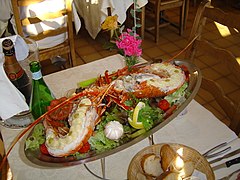
Lobster served traditionally

Poissonnerie (fish trade) in Le Bois-Plage

Swordfish in the St-Martin market


Agriculture
Mainly in the fertile east of the island, agriculture is practiced on more or less large plots . Mainly potatoes , vegetables and wine are grown on the island . The light to medium-heavy sandy soil allows the cultivation of potato varieties that are otherwise not found in France. They are the only potatoes in France that are allowed to carry the AOC label. The vegetables are marketed throughout France under the specially created and protected designation of origin "Île de Ré".
salt
A less important economic factor today is salt production in the salt marshes near Loix . They claim about 350 hectares. The growing along the banks samphire is sold fresh or preserved. In the past, donkeys were mostly used to work with the salt, the legs of which were dressed in checked trousers to protect them from insects. The trousers-wearing donkeys are one of the symbols of the island. A large herd still exists in the grounds of the fortress of Saint-Martin-de-Ré. The “Ecomusée des Marais Salants” provides information on the history of salt production on the Île de Ré.
Thalasso
On the south coast between Rivedoux-Plage and Sainte-Marie-de-Ré there is a well-known thalassotherapy center.
tourism
Up to 180,000 tourists a year find accommodation in the numerous hotels , holiday apartments and campsites of all categories. The average sunshine duration of 2,800 hours per year, the mostly flat sandy beach, the water tempered by the Gulf Stream and the fresh wind make Ré a family-friendly island. In addition, the island has more than 100 km of bike paths. Some nature reserves on the island are wetlands and can only be reached by bike or on foot. A large bird sanctuary, the “Réserve naturelle de Lilleau des Niges”, extends north of Ars-en-Ré.
- Changes due to tourism
In the time before the bridge was built, the island could only be reached by ferry service between La Pallice and Sablanceaux. In the summer months, waiting times of several hours were common. Since the construction of the bridge, tourism has multiplied and the island has faced many new problems, including an explosive rise in property prices. This has only increased since La Rochelle Airport has been served by several national and international airlines. Associated with the high base prices is also a strong emigration trend among the local population: Young people in particular are leaving the island because it is now difficult to find a house there. In 2020, the Île de Ré will be considered a refuge for rich French people and celebrities who have the largest number of registered second homes compared to other European countries .
For a long time, there was also a threat of urban sprawl through "wild camping", which the local authorities usually crack down on, but in some places it is tolerated (e.g. in Baleines and Patache). Camping is now also prohibited on your own property if it is undeveloped.
The increase in tourism has also brought advantages to the island: In the traditionally poor area, a lot of new (seasonal) jobs were created; The sales of farms could also be increased significantly. Another positive effect is the renovation of the village centers, which were mostly in poor condition in the 1980s.
traffic
Due to the steadily growing population and expanding tourism, it became necessary at the end of the 19th century to create better connections to the mainland. In 1875, a shuttle service between Rivedoux and La Pallice began with steam boats .
In July 1895, the railway between Ars-en-Ré and La Couarde was inaugurated. In the years that followed, the line was extended via Saint-Clément-des-Baleines to Les Portes-en-Ré . From this era only the Ars train station and the locomotive shed in Les Portes have remained since the railway ceased operations in 1935. The station serves the painter Philippe Deschamp as a studio and gallery, the former locomotive shed now serves as the fire brigade's coach house .
There is a regional bus route between the train station in La Rochelle and the towns on the Île de Ré, which commutes at least almost every hour to Saint Martin-de-Ré. During the summer holidays, two bus routes are in use that go every hour to every town. The bus routes also use the toll bridge to the mainland. The bus depot is located in Saint-Martin-de-Ré . In addition to the regional buses, several free shuttle buses commute within the towns and between neighboring towns, especially during the summer holidays.
Viticulture
Wine has been grown on the island since the 10th century, and from then on it was one of the most important sources of income alongside salt. The cultivation areas extended at times well over 1,500 hectares, so that the entire south-eastern part of the island, only interrupted by a few grain fields, was covered with vineyards. In the 18th century, between 20,000 and 40,000 barrels were regularly harvested. The plants were fertilized with seaweed. Viticulture on the island was not spared from the phylloxera disaster in the years 1875 to 1880. It had a strong effect on viticulture; only the plants that stood on the dunes were largely spared. Today, on the remaining 650 ha of vineyards (with an increasing tendency), the grape varieties Sauvignon Blanc (60 ha), Colombard (40 ha), Chardonnay (40 ha), Cabernet Sauvignon (160 ha), Cabernet Franc (160 ha) , Merlot (165 ha) and Ugni Blanc (35 ha) are cultivated.
The harvested grapes are pressed in the island's winegrowers' cooperative . This is where country wines are produced in the form of white, red and rosé, which are sold as Vin de Pays Charentais Île de Ré . In addition, the typical regional Pineau is made from white or red grape must called "Ilrhea". Since the Île de Ré is located on the north-western edge of the Cognac area, a cognac is also distilled under the name "Le Gouverneur".
history
Early history
Numerous historians suspect that today's island was still part of the mainland in Roman times and was separated by one of the numerous earthquakes in this area. The Hellenistic geographer Claudius Ptolemaeus reports a promontory at this location, but not an island. The 30 km long and up to five km wide island used to consist of the islands of Loix in the north, Ars with Saint-Clement-des-Baleines and Les-Portes-en-Ré in the west and the much larger island with Rivedoux-Plage, Sainte -Marie, La Flotte, Le Bois-Plage, Saint-Martin, and La Couarde-sur-Mer . Over the course of several centuries, the three islands (some historians even speak of four) were connected by sediment deposits .
During the Paleolithic the island was probably not yet inhabited because there was no protection for the people against the polar cold. Human life in the Neolithic can be proven through archaeological finds. In the 19th century, the Tumulus Peu Pierroux and the Menhir de la Pierre qui Vire were discovered near Bois . During excavations on the north coast, especially at the headland of Lizay, tools from the Neolithic and tools from the Bronze and Iron Ages were found.
Roman times
There is little evidence of the importance of the Roman presence on the island. At least a vase was discovered in La Flotte in 1852 , which was decorated with a representation of Bacchus . In the vase, which was closed with a lid, there were 800 coins that bore images of Roman emperors. By the beginning of the 4th century there is said to have been a Roman temple to Neptune in the village of Rouland, near Le Bois .
middle Ages
The island was ruled by the Dukes of Aquitaine in the first ten centuries of the current era . Around the year 700 Duke Eudes built a fortress near Sainte-Marie and a monastery in the settlement , where he is said to have spent his old age. After his death he was buried in Saint-Martin. In 1730, during construction work in the governor's house, a crown made of gilded copper and set with four precious stones, including a turquoise, was found in the floor. A fragment of a skull still hung on the metal. Historians agree that it is the crown and head of Duke Eudes. In 1854 the crown disappeared while being transported to the Imperial Museum in Paris and has been missing ever since.
From 845 to 868 there was a base of the Loire-Normans on the Île de Ré or in Saintes on the Charente . The strategically important island was badly affected in the Hundred Years War and the Huguenot Wars did not leave the island and its population unaffected.
Modern times

From around 1625 the island was ruled by Jean de Saint-Bonnet, Marquis de Toiras , who had previously conquered it from the Huguenots . He had the Fort de la Prée and the fortress of Saint-Martin-de-Ré built. At that time the island was at war and the English landed under Duke Buckingham in Sablanceaux to besiege Saint-Martin from there. Toiras succeeded with great difficulty, the worst deprivation of the population and with the help of a fleet of King Louis XIII. To evict Buckingham's troops from the island.

She subsequently remained under French rule. For his services, Thoiras was appointed Maréchal de France and entered the service of the Savoy royal family . At that time the fortifications were perfected by Vauban and completed in 1685. In 1696 an Anglo-Dutch fleet tried to occupy the island again, but the cannons of the coastal batteries in the fortress prevented a landing. The traditional headgear of women, the quichenotte, is said to date from the time of the English occupation . It is jokingly claimed that it was supposed to prevent the women from being kissed by the English all the time (Quichenotte = kiss not).
At the suggestion of the then marine director of Rochefort , Charles Colbert de Terron, Minister Colbert , who was also his cousin, arranged for the construction of the first lighthouse on the north coast of the island. It was completed in 1682.
The fortress of Saint-Martin served as a prison from the middle of the 19th century until 1946, from which convicts were embarked for French Guiana . One of the most famous prisoners waiting to be deported in the fortress of Saint-Martin was the French artillery captain Alfred Dreyfus . He was imprisoned in the fortress of 17 January to 21 February 1895 before due to his illegal conviction in the Dreyfus affair to the Devil's Island was deported. Today there is a large correctional facility for long-term prisoners in the fortress .

Several decades later, the islanders had to suffer from another occupation because the German Wehrmacht held the Île de Ré from 1940 to 1944. Even today you can find some abandoned bunker structures , mainly on the beaches of the south coast, which will probably need another century until the dune sand has completely covered them. Dismantling the works would be too expensive, and the bunkers are now a typical feature of the beaches and serve (unintentionally) as memorials. However, the bunkers are also a source of danger, especially for children playing.
Attractions
- Fortifications in Saint-Martin-de-Ré, built by Vauban
- Phare des Baleines (lighthouse of the whales), built in 1854 to replace the beacon erected in the 17th century by a building contractor from La Rochelle on the instructions of Minister Colbert
- Fish locks at Saint-Clément-des-Baleines and Sainte-Marie-de-Ré. Although they are under monument protection, they are maintained and operated by an interest group. The catch belongs to the members. A hike at low tide over the lock wall at the lighthouse is an interesting experience. At high tide, the tour is under water.
- Bird reserve Réserve naturelle de Lilleau des Niges, with an information center. Many species such as brent geese , teal ducks , curlews and silver plovers nest here on 1,500 hectares .
- Ruins of the Notre-Dame-de-Ré monastery
- The Peu Pierroux burial mound with a diameter of about 27 m consists of many flat stones. The central component is a stone table supported by seven columns . The columns are connected by small walls. In the rooms created in this way there are bones , clay dishes , stone axes , etc.
Sports
- surfing
- Golf (Gulf of Trousse-Chemise) in Les Portes-en-Ré
Press
The magazine “Le Phare de Ré” appears weekly.
photos

Ferry Maréchal de Toiras in front of the bridge under construction to the Île de Ré in November 1987. The construction of the bridge made the ferries superfluous.

Île de Ré, bridge between La Pallice and Rivedoux-Plage

new and old "whale lighthouse", Phares des Baleines, seen from the fish lock

Salt garden near Loix-en-Ré

Wine cooperative on the Île de Ré

New planting on the island
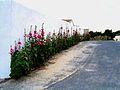
Hollyhocks all over the island


Web links
Individual evidence
- ↑ Eric Gaboriaud: Le Pont de l'île de Ré - Tarifs 2018, subscriptions pour vos vacances sur l'île de ré. Retrieved June 17, 2018 (French).
- ↑ a b Alexander Sarovic, Britta Sandberg, DER SPIEGEL: Escape from Corona: Where the rich keep their distance - DER SPIEGEL - Politics. Retrieved April 21, 2020 .
- ↑ Ruth Harris: The Man on Devil's Island - Alfred Dreyfus and the Affair that divided France. Penguin Books, London 2011, ISBN 978-0-14-101477-7 , p. 37