
Kahnsdorf
|
Kahnsdorf
municipality Neukieritzsch
Coordinates: 51 ° 9 ′ 55 ″ N , 12 ° 26 ′ 8 ″ E
|
||
|---|---|---|
| Height : | 132 m above sea level NN | |
| Area : | 60 ha | |
| Residents : | 540 (December 31, 2005) | |
| Population density : | 900 inhabitants / km² | |
| Incorporation : | January 1, 1994 | |
| Incorporated into: | Lobstädt | |
| Postal code : | 04575 | |
| Area code : | 03433 | |
Location of Kahnsdorf in Saxony |
||


Kahnsdorf is a district of the Saxon community Neukieritzsch in the district of Leipzig . This is located in the south of the Leipzig lowland bay on the edge of the Leipzig New Lakeland . The districts of Pürsten and Zöpen belong to Kahnsdorf.
Geographical location
Kahnsdorf is located south of Leipzig . Due to the lignite mining in the Witznitz II opencast mine , the local connections to the west, north and east were cut in the second half of the 20th century, giving Kahnsdorf a peninsula-like location in the opencast mine. After the renaturation of the open-cast mining area and flooding of the remaining holes , the Kahnsdorf , the Hainer and the Haubitzer See are now around Kahnsdorf , and a new road connection to Rötha was created.
history
The German settlement Kahnsdorf was probably built in the 12th to 13th centuries. The village was located between the two older Sorbian settlements of Zöpen and Pürsten. For these localities there is no exact date of their foundation. Fragments found in the village area indicate that the area was first settled in the transition from the Mesolithic to the Neolithic (5500-3500 BC).
middle Ages
It can be assumed that Pürstens (Porsten) was permanently settled at the end of the 6th century / middle of the 7th century . The place Zöpen (Czopen) was added insignificantly later. There is no documentary mention of the Sorbian settlement from this time.
For Zöpen, until the first documentary mention in 1410 by the Margraves Friedrich I and Wilhelm II of Meissen , all written reports from the earlier period are missing . Pürsten was first mentioned in 1216, but only in a document in 1378 in the register of the Pegau monastery . The place Condorf (Kahnsdorf) was probably first settled by Germans in the 12th to 13th centuries. The first documentary mention of Kahnsdorf goes back to the Heinemann de Kahnsdorf family in the feudal book of Friedrich des Strengen from 1350. This means that the youngest of the three settlements has the oldest first mention.
Since 1378 Porsten (old name Pürstens) belonged to the Amt (castrum) Borna . In 1466, Nickel Pflugk zu Knauthain was granted feudal rights to Porsten by Bishop Heinrich II of Naumburg . Until then, the Porsten estate was in the hands of Hans zu Horberg. In 1473 the church in Zöpen was consecrated to Saint Laurentius . As a result of the division of Leipzig in 1485, when the Wettin-Saxon territories were divided between the brothers Albert and Ernst, this territorial division also went through the three villages. Kahnsdorf and Pürsten came to the Albertine duchy, Zöpen to the Ernestine electorate. The ownership of the manors changed over time. In 1491 Herold von Weissenbach owned the Zöpen manor.
Early modern age

The old manor house Kahnsdorf 1850

... and 2013
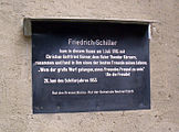
... with a Schiller memorial plaque


In 1574, jurisdiction over Pürsten was divided between Wolf von Breitenbach and the Kahnsdorf manor owner Joachim von Ponickau . For 1617, Jobst von Helldorf and Friedrich von Etzdorff (Kahnsdorfer squire) are named as court lords.
In 1767, the Kahnsdorf manor was sold to the Ernesti family of scholars from Leipzig. It is to this fact that Kahnsdorf owes a brief, but all the more important appearance on the world literary stage for cultural and literary studies. On July 1, 1785, the Kahnsdorf manor owner Johann Christian Ernesti , professor of theology at Leipzig University , invited Christian Gottfried Körner and Friedrich Schiller to Kahnsdorf. Since that meeting, Schiller and Körner ( Theodor Körner's father ) had a close friendship, which is said to have moved the poet Schiller to his poem An die Freude . A plaque on the old Kahnsdorf manor still reminds of this meeting today. In a fire in 1800 the rectory, the parish archive and 10 Hintersaesser houses were destroyed.
The Napoleonic Wars did not leave the place unscathed. In 1806, after the battle of Jena and Auerstedt , fleeing Prussian horsemen plundered several goods in the village. On June 17, 1813, Theodor Körner, lieutenant and adjutant in the Lützow Freikorps was seriously injured in a battle with the French near Kitzen . He was finally brought to the manor in Kahnsdorf via Leipzig, where he recovered for six weeks and then traveled on to Bohemia. This was done under the strictest secrecy, as Saxony was occupied by Napoleonic troops and the Saxon king was one of the most willing allies of the French emperor.

In the years that followed, Gut Kahnsdorf remained a focal point for cultural greats from Leipzig, especially the Gewandhaus Kapellmeister Felix Mendelssohn Bartholdy . He visited the Ernesti family several times in Kahnsdorf and found peace and relaxation here. In 1903 the new Kahnsdorf mansion was built.
In 1826 the Zöpen manor was owned by Karl Leopold von Beust , an ancestor of Ole von Beust , Hamburg mayor from 2001 to 2010. Kahnsdorf, Pürsten and Zöpen were in the Electoral Saxon and Royal Saxon authorities of Borna until 1856 . From 1856 the places belonged to the Borna court office and from 1875 to the Borna district administration .
Modern times
With the opening of the Leipzig-Altenburg section of the Leipzig-Hof railway line in 1842, Kahnsdorf and Pürsten received a connection to the rail network with a station on their corridor. But since both places refused to be named after their place, the stop was given the name of the place three kilometers away Kieritzsch . The settlement "Am Bahnhof Kieritzsch" developed in the immediate vicinity of the train station. Their corridor belonged to Pürsten in 1875 and to Kahnsdorf in 1905. The station, which was run as "Bahnhof Kieritzsch" until October 3, 1936, became important as a small railway junction with the opening of the lines to Borna (1867, extended to Chemnitz in 1872 ) and Pegau (1909).
The church in Zöpen was completely renovated in 1880/81, but the place lost its importance as a dominant parish and school location . After the settlement west of the Kieritzsch train station had grown considerably in the course of industrialization, around 1935 there was a need for an administrative reorganization compared to the villages of Kahnsdorf, Pürsten and Zöpen east of the railway line, which were merged to form the municipality of Kahnsdorf in 1934 . Then certain of the NS - Reichsstatthalter for Saxony , Martin Mutschmann , on November 1, 1935, the formation of the new municipality Neukieritzsch whose name adopted by the station the following year. After the Second World War, the Americans occupied the western part of Saxony up to the Elbe.
After the definition of the division of Germany into zones of occupation as a result of the Potsdam Conference , the Americans evacuated the occupied part of Saxony and the Leipzig area, and with it Kahnsdorf, came under Soviet rule. In the Soviet occupation zone the land of the large landowners was divided up as part of the land reform , including in Kahnsdorf. Both manors were dissolved and distributed to 35 new farmers. In 1953 two agricultural production cooperatives (type 1) were formed.
As a result of the opening of the Witznitz II opencast mine in 1946 , Kahnsdorf became an island location in the middle of the lignite industry over the next few decades. The opencast mine was located in the north of the town. Construction site 1 worked its way from the south around a pivot point west of Großzössen to the west side of Kahnsdorf between 1948 and 1961. In 1958 the connecting road to Neukieritzsch was cut. Shortly before, Kahnsdorf, Zöpen and Pürsten had also been separated from Neukieritzsch in terms of administration, and from January 1, 1957 they again formed an independent municipality of Kahnsdorf. With the construction of the pivot point Kahnsdorf northwest of the village, construction site 2 opened in 1960. As a result, Kahnsdorf was almost completely excavated by 1974, so that the place could only be reached via the road to the neighboring southern town of Großzössen. The progress of the opencast mine required the Pleiße to be relocated to the west between Kahnsdorf and Neukieritzsch in the 1960s. Kahnsdorf's neighboring towns Trachenau , Treppendorf , Kreudnitz , Hain and Kleinzössen disappeared through construction site 2 . The Hain corridor, which was devastated in 1968, was incorporated into Kahnsdorf in 1971.
From 1989/1990

With the turn of 1989/1990 came the end of the opencast mining and an improvement of the infrastructure. Above all, the drinking water connection of the place was finally restored. The open pit closed in 1993. The remaining open pit hole was until 2010 at a height of 126 m above sea level. NN flooded. The resulting Hainer See (the devastated former district of Hain was named after the name) developed into a local recreation area. There were concepts for the tourist use of the lakes. These ranged from an underwater hotel to a promenade with a harbor and a new "fishing village" to a holiday complex with a thermal bath. In the end, many single-family houses were built on the Kahnsdorf lagoon , a bay on Lake Hainer. The Kahnsdorfer See , named after the place, is reserved for nature conservation.
On January 1, 1994, Kahnsdorf were merged with Großzössen and Lobstädt to form the unified community Lobstädt . With the incorporation of the Lobstädt community on April 1, 2008, Kahnsdorf became part of the Neukieritzsch community for the second time since 1935.
In the 1990s, the Kahnsdorf infrastructure was largely improved and renovated. In 2001 the place celebrated its 651th anniversary; During this ceremony, the flag of the Kahnsdorf Volunteer Fire Brigade was consecrated.
politics
- The community coat of arms
The community Kahnsdorf consists of the three former villages Zöpen, Kahnsdorf and Pürsten. Because of the multiple renaming and incorporation of the place, the names Zöpen and Pürsten almost completely disappeared. The tripartite coat of arms of the place is supposed to symbolically keep these old village names alive. Zöpen is represented by the old fortified church from 1550 in the lower part of the coat of arms. The sheet of paper shown in the upper right part, which is covered by a silver quill pen, symbolizes the district of Kahnsdorf, from whose manor many poetic and cultural impulses emanated. For brushing there is the abbot crook in the upper left part. This symbolizes the close connections with the Pegau monastery .
Economy and Infrastructure
After the structural change and the associated loss of the lignite industry, the place has no industrial settlements. Craftsmen and service companies shape economic life.
In the nineties, the streets in the village in particular were renovated. The drinking and waste water supply was also completely renovated. Due to its island location, Kahnsdorf only had one street that led out of the village. Since 2001, a district road has been leading over the western rocky areas to Rötha . A reconnection to Neukieritzsch is being considered; the provision of financial resources alone will delay the project.
With the expansion of the former Witznitz II opencast mine into a local recreation area , Kahnsdorf is in a well-developed network of cycle paths. The expansion of the waterways for tourist use and the associated networking of the lakes in the southern region create further opportunities for the village.
Attractions
- Laurentiuskirche zu Zöpen


The first chapel in Zöpen was apparently built around 1004 to 1009. At that time, all pagan groves of gods were destroyed by Bishop Wigbert von Merseburg and replaced by church buildings. In 1473 it was named by Pope Sixtus IV as consecrated to St. Laurentius. The pulpit and altar date from 1693, and the church was also redesigned in that year. The nave has been rebuilt and renovated several times over the centuries. The tower was remodeled in 1744, renovated in 1787 and measured at 53.69 meters. A major renovation was due again in 1880/1881, whereby the chancel and tower remained and the entire central section was torn down and rebuilt.
From 1968 to 1970 there was an interior and exterior renovation. The altar crucifix rescued from the excavated church Hain was set up in the anteroom. During the last major renovation from 1990 to 1994, the tower clock was renewed and the church was given a new coat of paint both inside and out. To the left of the entrance door is the sandstone tombstone slab of noble Otto von Breitenbach from the Großzössen manor. Also on this side is an old offering box (early 18th century), ironed and fixed on a stone base. On the other side is the already mentioned altar crucifix of the Hainer church.
- Castle with manor

The Kahnsdorfer manor house is on the remains of a medieval moated castle . This was apparently built by the Frankish settlers on a defensive system (suburbia) of the Slavic inhabitants. This moated castle was surrounded by the Öltzschgraben and a moat. The moats were fortified by ramparts and palisades. A residential tower, probably made of wood or stone, stood on the core work called "Bühl". Later landlords extended this moated castle several times with stone houses, so that the manor Kahnsdorf was created. The owner family Forker-Schubauer built the new manor house in 1902 and redesigned the surrounding facilities. The moat was partially filled in, and the new mansion was given the shape of a castle surrounded by water. Overall, the renovations resulted in a mansion with a pond, which merged harmoniously into the park. During the GDR era, the old mansion was the seat of the council of the community. The new manor house housed apartments and the local daycare center. The built-in ballroom of the new mansion is still used today for meetings and celebrations. In addition to a restaurant, there are holiday apartments and the headquarters of Blauwasser Seemanagement GmbH , owner of the manor house, the adjacent lakes and the lake properties . The home parlor of the village of Kahnsdorf is located in the old manor house. Here the history of the place is presented in a museum.
- War memorial in churchyard
War memorial for the fallen and wounded in the Franco-German War of 1870/71. A cuboid stone was placed on top of the pyramid-shaped layered stones. The monument was surrounded by an iron fence and four linden trees were planted. The plaque with the inscription “Many moved out, two did not return” has not survived today.

- Plague column in the cemetery
In 1680 the village of Zöpen was ravaged by the plague ; the nearby villages of Kahnsdorf, Pürsten, Trachenau and Treppendorf were spared. This caused the residents to erect a plague column (plague stele), which is badly weathered today, in the Kahnsdorf cemetery as a souvenir.
- Memorial stone for Kreudnitz and Hain am Hainer See
Memorial stone between the former villages of Hain and Kreudnitz on the shore of Lake Hainer . This was set up by the organizers of the Hain-Kreudnitz meeting in 2005.
Club life
With the disappearance of many localities around Kahnsdorf and the strong migration of residents from the village, the diverse club life of the village community (singers' club , gymnastics club , sports, football club, etc.) came to a standstill.
Literature and Sources
- Rolf Ferstl: "The principalities" Zöpen, Kahnsdorf, Pürsten in the Saxon town of Pleißegau. A home book. Self-rel. d. Author, Hattenhofen 1994.
- Hans-Jürgen Ketzer: From Greece to Heuersdorf. Saxony's 48er in Bornaer Land . Sax-Verl. Beucha 2003.
- Bernd Rüdiger: The Borna Pleisseland. Destruction u. New beginning. Cape. On the development history of the Borna Pleisseland. Leipzig, 1994.
- Jörg Rogge, Uwe Schirmer (Ed.): High nobility in Central Germany (1200 to 1600). Forms - legitimation - representation. 2003.
- The Bornaer Pleisseland. Destruction u. New beginning. Edited by Pro Leipzig in Zsarb. with d. "Urban planning. Model project Bornaer Pleisseland ”and d. participating communities, Red .: Heinz-Jürgen Böhme u. a. Passage-Verl., Leipzig 1994.
Web links
- Pictures from Kahnsdorf in the Deutsche Fotothek
- Kahnsdorf in the Digital Historical Directory of Saxony
Individual evidence
- ↑ Rittergut Kahnsdorf, New Manor House (near Leipzig) on architektur-blicklicht.de
- ^ Karlheinz Blaschke , Uwe Ulrich Jäschke : Kursächsischer Ämteratlas. Leipzig 2009, ISBN 978-3-937386-14-0 , p. 62 f.
- ^ The Borna District Administration in the municipal directory 1900
- ^ Kieritzsch, Am Bahnhof in the Digital Historical Directory of Saxony
- ^ Steffen Kluttig: Rail connections between Chemnitz and Leipzig - the Kieritzsch – Chemnitz and Leipzig – Geithain railway lines. Bildverlag Böttger, Witzschdorf 2006, ISBN 3-937496-17-3 , p. 84 ff.
- ^ Kahnsdorf on gov.genealogy.net
- ^ The Witznitz opencast mine with map , LMBV publication
- ^ Grove in the Digital Historical Directory of Saxony
Deutzen | Big dogs | Kahnsdorf (with brushes and braids) | Kieritzsch | Lippendorf (Medewitzsch) | Lobstädt | Neukieritzsch . Devastations: Bergisdorf | Breunsdorf | Grove with Gutengröba | Small items | Peres | Mirror | Pulgar | Röthigen | Spahnsdorf .