
Karoo


The Karoo (also Karroo , formerly Karru ) is a semi-desert landscape in the high plains of South Africa , north of the Great Peripheral Step and in southern Namibia . A distinction is made between Small Karoo, Large Karoo and Upper Karoo as well as Succulent Karoo and Nama-Karoo. With an extension of 500,000 km², the Karoo covers almost a third of the territory of South Africa. The succulent caroo is one of the biodiversity hotspots on earth and a. systematically mapped within the framework of BIOTA AFRICA .
Term, extent of the area and options for structuring
The name Karoo comes from kurú from the language of the San who once lived and hunted here. In their language, this word means "dry, arid, stony land". The European immigrants, mostly of Dutch descent, transferred this term to the vegetation of these landscapes. They themselves called these regions in their language droogeveld , which means "dry field" in German
In South Africa the term is associated with ambiguous interpretations. Botanists, farmers, geographers and geologists have different views on this. Their variable perspectives have therefore also found their expression in cartography, which shows different expansions of the Karoo in atlases.
The delimitation of the Karoo term as an expression of its geographical extent can be derived from the composition of edaphic , geological - geomorphological , climatic and geobotanical features. The landscape character outlined in this way is unique in the world and only shows certain similarities with the Algerian steppe highlands of the Schotts . However, there are deviations from this if the landscape is described exclusively botanically or geologically.
The Karoo as a landscape in general understanding is a South African dry region within the Western Cape , Eastern Cape and North Cape provinces as well as in southern Namibia. It is therefore widespread that there are two distinct regions: the Great Karoo and the Little Karoo . From a geographical point of view, a conception of three sections had developed. This is the Lower Karoo (Small Karoo) a basin with average heights of 250 to 400 m between the chains of the Langeberge with the adjoining Outeniqua Mountains (south) and the Swartberge (north), the Middle Karoo (Great Karoo) of about 600 to 900 m between the Cape Mountains and the Great Edge Step and the Upper Karoo ( Central Plateau , sometimes referred to as the "Highveld"), from the Great Edge Step down on average from 1800 to 1000 m above sea level. M. to the Orange River .
Big and Small Karoo
The Great Karoo has a west-east extension of over 750 kilometers and a north-south extension of about 110 kilometers. It is bounded in the west by the cedar mountains and in the east by the winter mountains. In the north, the mountain ranges of the Roggeveld , Koms , Nuweveld and Sneeuberg and in the south the mountain ranges of the Witteberge, Groot Swartberge and Groot Winterhoek form the natural boundary.
To the south of this region, bounded by the Swartberg Mountains in the north, the Little Karoo extends in an evacuation basin . This in turn is bounded on its southern flank by the coastal Langeberg and Outeniqua Mountains .
In contrast to this traditional structure, the Karoo is divided into an eastern part, the Nama Karoo, and a western part, the Succulent Karoo, according to vegetation-geographic aspects, whereby the overall extent of the Karoo according to this concept also deviates from that of the traditional approach .
Nama-Karoo
According to the modern view, landscapes north of the Great Karoo described above, from Teekloof Pass , Fraserburg and Snyderspoort in the southeastern part of the Namakwa district to north of the Orange River to Namibia, are also considered to belong to the Karoo region and mostly with the term “Nama -Karoo "(formerly Upper Karoo ) occupied.
Succulent Karoo
To the west of the Nama-Karoo, the so-called "Succulent Karoo" stretches along the coast in the north of the Western Cape Province, in the west of the North Cape Province and in the southwest of Namibia. It occupies an area of about 110,000 square kilometers. "Succulent caroo" is a vegetation topographical term. This vegetation area has a south-eastern spur that intersects with the landscape of the Great Karoo east of the Cedar Mountains. The section close to the coast is the Knersvlakte . There are around 1700 species of succulents here .
Another vegetation-topographical term is Strauchkaroo , which describes an area with a typical plant community of the arid areas in the provinces of Western Cape, North Cape, Eastern Cape and Free State . This zone takes up about a third of the South African territory.
The succulent caroo has been on Namibia's tentative list for nomination as Namibian World Heritage since the end of October 2016 .
Landscapes

Landscape in the Little Karoo
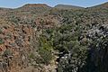
Great Karoo: The Rooiwalle Canyon at the Klipspringer Pass (Western Cape)
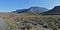
Great Karoo: Nuweveld Mountains, a section of the Great Peripheral Step (Western Cape)

A Karoo acacia tree in winter
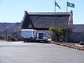
Entrance to Karoo National Park at Beaufort West

.jpg)
.jpg)


National parks and protected areas
The Karoo National Park near Beaufort West is a relatively small protected area on the northern edge of the Great Karoo. There are also the Tankwa Karoo National Park near Tweefontein and the "Gondwana Sperrgebiet Rand Park" in Namibia.
History and economy
The Karoo remained almost untouched by non-African settlers until 1800. Until then, large herds of antelopes , zebras, and other large wildlife had crossed the area's grassy areas. Khoi and San, who are among the last descendants of the Stone Age man of southern Africa, wandered through the Karoo in its entire extent. Neither Europeans nor African Bantu were interested in settlement due to the dry climatic conditions. The two main ethnic groups residing in the Karoo differed significantly in their way of life: the Khoi raised sheep and cattle, while the San lived as hunters and gatherers. With the occupation of the Karoo by Europeans, the sensitive climatic balance was changed due to excessive sheep farming and the associated grazing of the pastures. The landscape suffered long-term damage and the semi-desert-like areas expanded considerably. This process began at the end of the 18th century with the herding of merino wool . The soil erosion intensified after the Second World War due to the spread of the Karakul sheep herds ( Persian fur ) from Namibia .
In the mid-19th century, the rail network was expanded from southern Worcester to the Karoo. In the course of the ever more extensive agriculture in the Little Karoo, railway lines were built in and to this region. The cultivation and export of alfalfa as animal feed made it necessary to transport large quantities of goods effectively. This development had a significant influence on the construction of railway lines such as: Port Elizabeth - Klipplaat (1880), Klipplaat - Willowmore - Oudtshoorn - Mossel Bay / Calitzdorp (1903) and Touwsrivier - Ladismith (1904). Connections to Bechuanaland , South West Africa , Johannesburg , Rhodesia and far beyond followed. This change had far-reaching social, economic and ecological consequences.
During the Second Boer War (1899–1902), the Karoo were drawn into the conflict on numerous fronts. In a bloody guerrilla war there were heavy casualties on both sides. Many now abandoned log cabins can be viewed at strategic points in the Great Karoo.
Today, sheep farming is still the economic backbone of the Karoo. Other forms of agriculture exist where artificial irrigation is possible. Further economic areas were opened up by farms with wild animals and the expansion of tourism. Since the end of the 20th century, increased efforts have been made to protect nature.
On the northwestern edge of the Karoo, in the Namakwa district , copper ores are mined near Okiep and Nababeep . Modern copper mining has its roots in pre-European prospecting and metal processing by the local population. Their copper dishes caught the attention of Europeans in barter. The governor of the Cape Province Simon van der Stel then commissioned an expedition to Namaqualand . As a result, from 1852 onwards, organized copper ore mining was carried out by Weisse.
In Laingsburg
At Willowmore

At Willowmore
At Britstown


climate
The Karoo is surrounded by the mountain ranges of the Rim Mountains. The damp sea breezes are already raining down on the windward sides of the mountain slopes, so that the land behind the mountains remains largely dry. This is why the climate is arid , with precipitation below 500 millimeters per year and less than 200 millimeters in the desert-like northeast. In the eastern part the little rainfall falls mainly in summer. In the further western and northern areas, precipitation tends to fall in winter. While the summers are hot, the winters can be very cold.
Vegetation and fauna
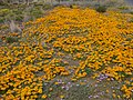
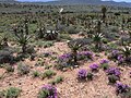
In addition to the neighboring Fynbos area, the Karoo is home to other types of flora typical of southern Africa. The Karoo is known for the variety of succulent species, especially the midday flowers . When there is enough winter rain, the plains are covered with flowering carpets of plants, for example in Namaqualand.

Near Laingsburg

Near Laingsburg

Near Laingsburg

Near Laingsburg


Part of the Great Karoo near Beaufort West has been protected as a Karoo National Park since 1979 . Here also lives big game such as eland , gemsbok , Cape mountain zebra and black rhino . The Karoo is also home to a number of reptiles. Here, for example , the areole flat turtle and the smallest species of turtle, the sawn flat turtle , are at home.
geology
The Karoo subsoil consists of sedimentary rocks of the Permian and Triassic , mainly sandstones , pelites and conglomerates , which in turn are part of the sediment filling of the much larger Karoo basin . The Karoo Basin extends beyond the Eastern Cape to Lesotho , the Free State and KwaZulu-Natal . It contains deposits that were created by the activity of glaciers, deposits of a huge former lake or inland sea and sediments of an extensive former lowland , which were mostly deposited by rivers, but also partly by wind. A basalt ceiling forms the end of this sequence .
For the Karoo ecosystem, as elsewhere, regional geology is an important factor. In large parts of the Karoo there are sandstones at and near the surface. Sandstones are generally porous and therefore extremely permeable to water. This is why rainwater can seep away quickly, which increases the drought in the region, which is already poor in precipitation. Last but not least, these climatic and geological conditions are the cause of the specific flora and fauna of the Karoo.

Hill in the Karoo National Park, the hill consists predominantly of Permian Pelites of the Abrahamskraal or Teekloof Formation of the Beaufort Group. The hilltop is formed by a relatively solid sandstone.
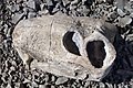
Fossil skull of a Gorgonopsier exhibited in the Karoo National Park near Beaufort West, a relatively typical fossil in the rocks of the Karoo.


literature
- Gustav Fritsch: South Africa to the Zambesi. I. Department The country with its vegetal and animal inhabitants . Leipzig, Prague (G. Freytag, F. Tempsky) 1885
- Ernst Klimm, Karl-Günther Schneider, Bernd Weise: Southern Africa . Scientific Country Customers; Vol. 17. Wiss. Buchgesellschaft, Darmstadt 1980, ISBN 3-534-04132-1
- Nick Norman, Gavin Whitefield: Geological Journeys . Cape Town (Struik Publishers) 2006 ISBN 1-77007-062-1
- AW Rogers, AL Hall, PA Wagner, SH Haughton: The Union of South Africa. Handbook of Regional Geology. VII. Vol. Section 7a, Heidelberg 1929
- Roger MH Smith, Patrick G. Ericsson, Willem J. Botha: A review of the stratigraphy and sedimentary environments of the Karoo-aged basins of Southern Africa. Journal of African Earth Sciences. Vol. 16, No. 1/2, 1993, pp. 143-169. doi: 10.1016 / 0899-5362 (93) 90164-L
Individual evidence
- ↑ Traugott Molter: Water balance and irrigation agriculture in the Cape . Franz Steiner Verlag , Wiesbaden 1966, p. 28 (footnote)
- ^ Molter: water balance . 1966, p. 27
- ^ Molter: water balance . 1966, pp. 27-28
- ^ Molter: water balance . 1966, pp. 25, 29
- ↑ Klimm, Schneider, Weise: Southern Africa. Pp. 37, 94-98
- ^ Rüdiger Wittig, Manfred Niekisch: Biodiversity: Fundamentals, Endangerment, Protection. Springer, Heidelberg 2014, ISBN 9783642546945 , p. 110. Excerpts from books.google.de
- ↑ Klimm, Schneider, Weise: Southern Africa. Pp. 48-49
- ↑ Traugott Molter: water balance . 1966, p. 151
- ↑ Klimm, Schneider, Weise: Southern Africa. Pp. 120-121.
- ↑ The entire paragraph is based on Smith, Ericsson, Botha: A review […] of the Karoo-aged basins of Southern Africa.
Web links
- Website of the Nama Karoo Foundation (English)
- Outline of South Africa by vegetation areas (English)
- Biodiversity of the Karoo ( Memento of October 11, 2008 in the Internet Archive )
- Expansion of the Karoo areas, overview map (English)