Kysucké Nové Mesto
| Kysucké Nové Mesto | ||
|---|---|---|
| coat of arms | map | |

|
|
|
| Basic data | ||
| State : | Slovakia | |
| Kraj : | Žilinský kraj | |
| Okres : | Kysucké Nové Mesto | |
| Region : | Severné Považie | |
| Area : | 26.414 km² | |
| Residents : | 14,953 (Dec 31, 2019) | |
| Population density : | 566 inhabitants per km² | |
| Height : | 358 m nm | |
| Postal code : | 024 01 | |
| Telephone code : | 0 41 | |
| Geographic location : | 49 ° 18 ' N , 18 ° 47' E | |
| License plate : | KM | |
| Kód obce : | 509256 | |
| structure | ||
| Community type : | city | |
| Urban area structure: | 4 districts | |
| Administration (as of November 2018) | ||
| Mayor : | Marián Mihalda | |
| Address: | Mestský úrad Kysucké Nové Mesto námestie Slobody 94 02401 Kysucké Nové Mesto |
|
| Website: | www.kysuckenovemesto.sk | |
| Statistics information on statistics.sk | ||
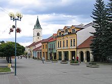
Kysucké Nové Mesto (German Kischützneustadt / Oberneustadel , Hungarian Kiszucaújhely - until 1882 Kisucaújhely , Polish Kisucke Nowe Miasto ) is a city in northwestern Slovakia.
The area was first mentioned in writing as terra Jesenin in 1244 and then also the city in 1254 . In 1325 a market was mentioned under the name of Congesberg . Kysucké Nové Mesto is divided into the following 4 districts:
- Budatínska Lehota (incorporated in 1973)
- Dubie (incorporated in 1895)
- Kysucké Nové Mesto
- Oškerda (incorporated in 1973)
The name addition "Kysucké" is derived from the location in the Kysuce region .
Town twinning
-
 Rive-de-Gier , France
See also
- List of cities in Slovakia
- Neustadt (place name) , for onenology
Web links
Commons : Kysucké Nové Mesto - collection of images, videos and audio files

