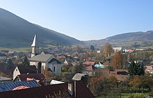
Ochodnica
| Ochodnica | ||
|---|---|---|
| coat of arms | map | |

|
|
|
| Basic data | ||
| State : | Slovakia | |
| Kraj : | Žilinský kraj | |
| Okres : | Kysucké Nové Mesto | |
| Region : | Severné Považie | |
| Area : | 18.052 km² | |
| Residents : | 1,922 (Dec. 31, 2019) | |
| Population density : | 106 inhabitants per km² | |
| Height : | 403 m nm | |
| Postal code : | 023 35 | |
| Telephone code : | 0 41 | |
| Geographic location : | 49 ° 21 ' N , 18 ° 47' E | |
| License plate : | KM | |
| Kód obce : | 509329 | |
| structure | ||
| Community type : | local community | |
| Administration (as of November 2018) | ||
| Mayor : | Radoslav Ďuroška | |
| Address: | Obecný úrad Ochodnica 121 023 35 Ochodnica |
|
| Website: | www.ochodnica.sk | |
| Statistics information on statistics.sk | ||
Ochodnica (Hungarian Ösvényes - until 1907 Ochodnica ) is a municipality in northwestern Slovakia , with 1922 inhabitants (as of December 31, 2019) and is located in Okres Kysucké Nové Mesto , a district of Žilinský kraj .
geography
The municipality, which is part of the traditional Kysuce landscape, is located at the eastern end of the Javorníky Mountains on the Ochodničanka brook , which flows into the Kysuca as a tributary on the right bank. Around the place are some traditional small settlements (Slovak Kopanice ) scattered. The town center, located at an altitude of 403 m nm , is seven kilometers north of Kysucké Nové Mesto .
history
Ochodnica was founded with the neighboring village Dunajov in the 16th century under Wallachian law , in the area of Lieskovec . At the time of its establishment in 1596, the village was part of the Budatín estate . In 1783 there are 175 houses and 988 inhabitants. The first parish was only founded in 1789.
Attractions
- Roman Catholic Martinskirche from 1789
- a chapel from the 19th century
- Mineral spring above the village

