Lüdersdorf (Bebra)
|
Ludersdorf
City of Bebra
Coordinates: 50 ° 57 ′ 38 " N , 9 ° 45 ′ 46" E
|
|
|---|---|
| Height : | 236 (227-244) m |
| Area : | 8.54 km² |
| Residents : | 184 (1988) |
| Population density : | 22 inhabitants / km² |
| Incorporation : | December 31, 1971 |
| Postal code : | 36179 |
| Area code : | 06622 |
Lüdersdorf is a district of the town of Bebra in the Hersfeld-Rotenburg district in northeastern Hesse .
Geographical location
The district of Lüdersdorf is located southwest of the core town of Bebra in a side valley of the Fulda . The foothills of the Knüllgebirge and the Lüdersdorfer Forst in the west form a natural border with the neighboring municipality of Ludwigsau . Furthermore, the place is limited to the north by the Rotenburg district of Dickenrück and to the east by Breitenbach . District road 60 leads through the village .
The small stream that flows through the village and rises to the east in the Lüdersdorfer Forest, flows into the Fulda behind Breitenbach.
history
The village was mentioned for the first time in writing in a document from the Blankenheim Provostry dated December 5, 1337 as Ludolfestorf in a barter between the brothers Johannes and Heinrich von Weiferode and the Blankenheim monastery for seven acres of land near Breitenbach . It can be assumed that the place existed before 1337. Judging by the later development, the place had about six to eight houses at that time.
According to the chronicle for the 650-year existence of the place, which was created with the help of the State Archives in Marburg , there are two possible origins of the name,
- the founder of the village was probably called Ludolf, so Ludolfes Dorf . A corresponding noble family can be found with the Liudolfingers and their progenitor Count Liudolf , whose son Otto I was lay abbot of the Hersfeld Abbey . Until the 14th century, the region around the Fuldaknie (today's urban area of Bebra) belonged to the sphere of influence of the Imperial Abbey of Hersfeld.
- Alternatively, the place could have been named after the Ludowingers who built Rodenberg Castle in neighboring Rotenburg .
Due to the validity of the neighboring town of Blankenheim as a monastery of the Hersfeld Abbey. Lüdersdorf, the former Lutolfesdorf, is mentioned several times in correspondence in the 14th century. The field names Streitsgraben , Herrenwiese , also Herrenteich and Lampersgraben , which are still in use today, date from the time around 1525, when Landgrave Philip I moved against Hersfeld . The quarrel may refer to a skirmish between opposing parties.
In 1538 the place was first named Leudersdorff in a Salbuch von Rotenburg :
"Leudersdorff
That village is with all authority, judgment, commandment, prohibition !, service and Schopftryfft our gf and master.
This village of Ingesessen does not need to do any service, because if the Jadt are concerned, they have to go for it, cut hedges, what must be caught at Wilpret for Rottenbergk and what they are called to do. "
“Leudersdorff
The village is subject to our most gracious prince and lord with all authority, judgment, command, prohibition, service and riding.
Resident of this village do not need to do any service, because when it comes to the hunt, they have to drive, cut hedges, whatever game is caught must be taken to Rotenburg and whatever else they are ordered to do. "
At that time the place consisted of 16 houses. Likewise, the place is referred to in the local tax book of Landgrave Philip II from the year 1585 as Leudersdorff and is given as 20 households. The Lords of Riedesel , the Dörnberg Junkers and those of Baumbach also had estates in the Lüdersdorfer district . According to the Rotenburger Salbuch of 1627, the Riedesel had not only lands but also a farm in the village.
Thirty Years War and Subsequent Centuries
In the Thirty Years' War Lüdersdorf, as many places in the area, completely destroyed. The anger of Tilly was drawn to the region by raids by the Breitenbachers and Blankenheimers on convoys of the imperial army . At times the area was also occupied by Tilly's troops. In an inventory from 1639, officials of the government in Kassel counted three Lüdersdorfer men who owned a cow. In addition, none of the surrounding fields was cultivated. In 1627 the place had 17 inhabitants.
Towards the end of the Thirty Years' War, the place was spared further acts of war. At the end of 1657 seven households with 37 inhabitants were found in the village. As the local church had been destroyed by the war, church festivals had to be celebrated in Breitenbach for many years.
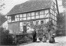
Most of the half-timbered houses that are still preserved today were built at the beginning of the 18th century. For example, the building that houses the village pub today dates from 1716. The restaurant next to the building, which was used until 1860, dates from 1717. Finally, in the 18th century, the place is listed in the archives of the Hessian State Archives in Marburg and the parish registers from Breitenbach as a song village designated. In 1747 the place had 20 households and 26 houses and thus about the same number as before the Thirty Years War in 1585.
At the end of the 19th century an extensive land consolidation of the surrounding lands was carried out. As a result, the number of land owned by the largest landowners has been reduced from several hundred to less than ten per owner. Before that it was necessary to cultivate several small plots, which were often separated from each other by small strips of land.
In 1890, the merchant Johannes Scheuch managed a grocery store . In addition, it was from 1851 to 1900 two forges , a wheelwright , a shoemaker , a tailor , a miller , a carpenter , a potter who also Ziegler was a master mason and a carpenter in the village.
20th century until today
At the beginning of the century, festivals such as the fair on the village square were held in Lüdersdorf. Subsequently, the surrounding farmhouses were used alternately every year as a stop for the fair society . In 1911 the restaurant was expanded to include a hall in which parties could now be held. In the same year, a joint water supply between Breitenbach and Lüdersdorf was set up, which was fed from the local springs. The town's wells were subsequently filled in. In 1922 the first households were supplied with electricity . In 1939 the village had 165 inhabitants.
On April 1, 1945, American troops advanced from Ludwigsauer Besengrund through the Lüdersdorfer Forest. Before that, the people of Breitenbach, assuming the Americans would come via Blankenheim, had come to safety in Lüdersdorf. When marching in from the west, there were fatalities to mourn. During and after the chaos of war, numerous expellees settled in the village, of which around five families remained in the village.
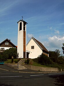
After the end of the Second World War, numerous half-timbered houses were demolished and modern houses were built instead. The new church was completed in 1959. Until 1970 Lüdersdorf had no thoroughfare to Rotenburg. The only way to and from Bebra was via Breitenbach. The construction of Kreisstraße 60 through the village turned the village from a dead end into a transit station. As part of the Hessian regional and administrative reform , Lüdersdorf was incorporated into the city of Bebra on December 31, 1971 .
The Lüdertalhalle, built in the core of today's townscape, was built in 1975/76 with the help of local and foreign citizens. However, this is not the only personal contribution of the Lüdersdorfer citizens. For example, a new fire station was built right next to the Lüdertalhalle in the 1990s .
In 2010 Lüdersdorf was drawn in the HR competition "Dolles Dorf" and thus had the opportunity to present the village and its residents to a film team from the Hessian broadcasting company. With the subsequent telephone Ted, Lüdersdorf could take second place of the week. Since only the group winner gets into the next round, this was the end for the "Dolle Dorf" application from Lüdersdorf.
Culture and sights
societies
There are currently four active clubs in the village:
- Volunteer firefighter
- Country Women's Association
- Men's choir Eintracht
- Table tennis club
In addition to organizing their own club life, the clubs also try to make a contribution to village life. Every year they organize various events, for example a village festival for the erection of the maypole and a fair on November.
Buildings
In Lueders Wald is a memorial to the former deserted Gert Ingers . The memorial consists of the former church stones of the desert and now has a resting place.
Web links
- Districts. In: Internet presence. City of Bebra
- Lüdersdorf, Hersfeld-Rotenburg district. Historical local dictionary for Hessen. In: Landesgeschichtliches Informationssystem Hessen (LAGIS).
- Literature about Lüdersdorf in the Hessian Bibliography
Individual evidence
- ^ Lüdersdorf, Hersfeld-Rotenburg district. Historical local dictionary for Hessen. (As of December 2, 2015). In: Landesgeschichtliches Informationssystem Hessen (LAGIS).
- ^ Hans Grunz: Chronicle of the 650th anniversary, 1987 ( Memento from November 12, 2004 in the Internet Archive )
- ↑ The source is apparently confusing Liudolf's date of birth (Chronicle: 866) with his date of death (866)
- ^ Cosima Göpfert: The Liudolfinger in Thuringia in the late 9th and early 10th century. Shifts in power politics with a view to the Hersfeld monastery and the Babenberg feud in 2012, ISBN 978-3-656-15199-9
- ^ Federal Statistical Office (ed.): Historical municipality directory for the Federal Republic of Germany. Name, border and key number changes in municipalities, counties and administrative districts from May 27, 1970 to December 31, 1982 . W. Kohlhammer, Stuttgart / Mainz 1983, ISBN 3-17-003263-1 , p. 406 .


