
Mtarfa
| coat of arms | map |
|---|---|

|
  |
| Basic data | |
| State : | Malta |
| Gzejjer : | Malta Majjistral (Northwest Malta) |
| Distretti : | Western film |
| Area : | 0.724,656 km² |
| Residents : | 2615 (December 31, 2018) |
| Population density : | 3609 inhabitants / km² |
| ISO 3166-2 : | MT-35 |
| Postal code : | MTF |
| Website : | lc.gov.mt/Page.aspx?catid=21&pid=184&lid=1 |
| politics | |
| Mayor : | Anthony Mifsud ( PN ) |
Coordinates: 35 ° 53 ' N , 14 ° 24' E
Mtarfa (or L-Imtarfa ) is a small town near the cities of Rabat and Mdina in the center of Malta .
Mtarfa is now a modern settlement. But there are Roman writings that refer to a temple of Proserpine .
history
In 1890 barracks were built for the British Army . During the First World War , the Royal Navy Hospital Mtarfa , a naval hospital, was built . Today it is a secondary school named after Sir Temi Żammit. The British built a chapel dedicated to Saint Oswald during the colonial days of Malta . Since 1900, Marfa was the terminus of the 1931 shutdown Valletta – Mdina railway .

Mtarfa clock tower
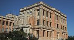
Royal Navy Hospital

St. Oswald Chapel


sons and daughters of the town
- Mark Loram (* 1971), British track athlete
- David Millar (* 1977), British professional cyclist
Web links
Individual evidence
- ↑ StatDB of the National Statistics Office Malta , accessed on August 1, 2020
Malta Island: Attard | Balzan | Birgu (Vittoriosa) | Birkirkara | Birżebbuġa | Bormla (Cospicua) | Dingli | Fgura | Floriana | Gudja | Gżira | Għargħur | Għaxaq | Ħamrun | Iklin | Isla (Senglea) | Kalkara | Kirkop | Lija | Luqa | Marsa | Marsascala | Marsaxlokk | Mdina | Mellieħa | Mġarr | Mosta | Mqabba | Msida | Mtarfa | Naxxar | Paola | Pembroke | Pietà | Qormi | Qrendi | Rabat | Safi | Saint Julian's (St. Julian's) | San Ġwann | San Pawl il-Baħar (St. Paul's Bay) | Santa Luċija | Santa Venera | Siġġiewi | Sliema | Swieqi | Ta 'Xbiex | Tarxien | Valletta | Xgħajra | Żabbar | Żebbuġ | Żejtun | Żurrieq
Gozo Island:
Fontana |
Għajnsielem |
Għarb |
Gasri |
Kerċem |
Munxar |
Nadur |
Qala |
Rabat (Victoria) |
San Lawrenz |
Sannat |
Xagħra |
Xewkija |
Żebbuġ
For some municipalities, the English name is also given in brackets.