
Latnaya
| Urban-type settlement
Latnaya
Latnaya
|
||||||||||||||||||||||||||||||||||||
|
||||||||||||||||||||||||||||||||||||
|
||||||||||||||||||||||||||||||||||||
.png)
.gif)
.svg)

Latnaja ( Russian Латная ) is an urban-type settlement in the Voronezh Oblast in Russia with 7528 inhabitants (as of October 14, 2010).
geography
The place is a good 20 km as the crow flies west of the city center of the Voronezh Oblast Administrative Center on the watershed between the right Don tributaries Weduga and Dewiza .
Latnaja belongs to Rajon Semilukski , located about 10 km southwest of the county seat Semiluky and is the seat and only town in the municipality Latnenskoje gorodskoje posselenije.

Church in Latnaya

railway station
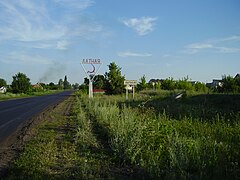
Town entrance

Pond on the southern edge of the settlement


history
In 1887 a settlement called Latnenskije dworiki was mentioned for the first time in place of the current village , with a name reference to the village of Latnoje located about five kilometers northeast , dworiki means "small farms". When the Kursk - Voronezh railway line passed by in 1894, a station was opened there and named after the village, and in 1896 a firebrick factory was opened nearby , based on an important clay deposit in the south .
The station settlement gained greater importance after the plant, which burned down during the Russian Civil War in 1920, was rebuilt in 1926–1929. During the Second World War , the settlement was occupied by the German Wehrmacht from the beginning of July 1942 to the end of January 1943 , and the plant was destroyed again. On February 12, 1944 Latnaya received urban-type settlement status.
Population development
| year | Residents |
|---|---|
| 1959 | 5570 |
| 1970 | 7488 |
| 1979 | 7461 |
| 1989 | 7496 |
| 2002 | 7333 |
| 2010 | 7528 |
Note: census data
traffic
The federal trunk road R298 Kursk - Voronezh - Borisoglebsk runs south of the village . The Latnaya train station is at kilometer 220 on the Kursk - Voronezh route. There, a freight connection line branches off to the clay pits south of the village and to businesses in the urban-type Streliza settlement six kilometers to the south .
Web links
Individual evidence
- ↑ a b Itogi Vserossijskoj perepisi naselenija 2010 goda. Tom 1. Čislennostʹ i razmeščenie naselenija (Results of the All-Russian Census 2010. Volume 1. Number and distribution of the population). Tables 5 , pp. 12-209; 11 , pp. 312–979 (download from the website of the Federal Service for State Statistics of the Russian Federation)
| Cities |
Bobrow R | Boguchar R | Borissoglebsk S | Buturlinowka R | Ertil R | Kalatsch R | Liski R | Novochopjorsk R | Novovoronezh S | Ostrogoshsk R | Pavlovsk R | Poworino R | Rossosh R | Semiluki R | Voronezh S |
|
| Urban-type settlements |
Anna R | Chocholski R | Davydovka | Gribanowski R | Jelan-Kolenowski | Kamenka R | Kantemirowka R | Latnaya | Nizhny Kislyai | Novochopjorsky | Olchowatka R | Panino R | Perelyozhinsky | Podgorensky R | Ramon R | Streliza | Talovaya R |
|
| Other Rajon centers |
Kashirskoye | Nizhnedevitsk | Novaya Usman | Petropavlovka | Repjowka | Ternowka | Werchni Mamon | Verkhnyaya Khava | Vorobyovka |