
Podgorensky
| Urban-type settlement
Podgorensky
Podgorensky
|
||||||||||||||||||||||||||||||||||||
|
||||||||||||||||||||||||||||||||||||
|
||||||||||||||||||||||||||||||||||||
.png)
.gif)
.svg)

Podgorenski ( Russian Подго́ренский ) is an urban-type settlement in the Voronezh Oblast in Russia with 6136 inhabitants (as of October 14, 2010).
geography
The place is a good 140 km as the crow flies south-southeast of the Voronezh Oblast Administrative Center . It is located on the Suchaja Rossosch, a left tributary of the right Don- tributary Chornaya Kalitwa (Black Kalitwa).
Podgorenski is the administrative center of the Podgorensky Rajons and the seat of the municipality Podgorenskoje gorodskoje posselenije, which also includes Sloboda Podgornoje, which adjoins west to northwest, and the hamlets of Golubin (2 km southeast), Lugovoi (2 km southwest) and Shchedrin (7 km north).
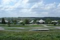
Partial view of the settlement

Raw material ropeway to the cement factory

Church in the old part of the municipality Sloboda Podgornoje

Podgornoje railway station


history
The place goes back to the Sloboda Podgornaja , which was built around the turn of the 18th century. In 1740 a large number of serf farmers were resettled there, which led to an economic boom. In the 1850s, the place became the seat of a Volost of Ujesds Ostrogoschsk of the Voronezh governorate .
On July 1, 1928, the village, now called Podgornoje , became the administrative seat of a newly created Rajons named after her. During the Second World War , the place was occupied by the German Wehrmacht from July 7, 1942 to January 17, 1943 .
After the war, a large cement factory was built on the basis of limestone deposits to the west of the village, which resulted in a workers' settlement. On June 9, 1958, it was given the status of an urban-type settlement under its current name. The administrative seat of the Rajon was moved there and the original Sloboda was subordinated to the settlement.
Population development
| year | Residents |
|---|---|
| 1897 | 6034 |
| 1939 | 6481 |
| 1959 | 4173 |
| 1970 | 5227 |
| 1979 | 5975 |
| 1989 | 7083 |
| 2002 | 6745 |
| 2010 | 6136 |
Annotation: census data (1897: Sloboda Podgornaja, 1939: Podgornoje village)
traffic
In Podgorensky, the Podgornoje station is located at kilometer 760 of the railway line Moscow- Voronezh- Rostov-on-Don, which opened on this section in 1871 and has been electrified since 1964 .
The regional road 20K-W33-0 (formerly R185), coming from the border of Belgorod Oblast (from Belgorod - Nowy Oskol ) via Rossosch , runs past the southern edge of the settlement , which continues to the federal trunk road M4 Don north of Pavlovsk leads. In a westerly direction the regional road 20K-1-24 branches off to the road Voronezh - Ukrainian border (direction Luhansk ), which is just under 20 km away , to the north the 20N-W26-0 leads to Kamenka .
Web links
Individual evidence
- ↑ a b Itogi Vserossijskoj perepisi naselenija 2010 goda. Tom 1. Čislennostʹ i razmeščenie naselenija (Results of the All-Russian Census 2010. Volume 1. Number and distribution of the population). Tables 5 , pp. 12-209; 11 , pp. 312–979 (download from the website of the Federal Service for State Statistics of the Russian Federation)
| Cities |
Bobrow R | Boguchar R | Borissoglebsk S | Buturlinowka R | Ertil R | Kalatsch R | Liski R | Novochopjorsk R | Novovoronezh S | Ostrogoshsk R | Pavlovsk R | Poworino R | Rossosh R | Semiluki R | Voronezh S |
|
| Urban-type settlements |
Anna R | Chocholski R | Davydovka | Gribanowski R | Jelan-Kolenowski | Kamenka R | Kantemirowka R | Latnaya | Nizhny Kislyai | Novochopjorsky | Olchowatka R | Panino R | Perelyozhinsky | Podgorensky R | Ramon R | Streliza | Talovaya R |
|
| Other Rajon centers |
Kashirskoye | Nizhnedevitsk | Novaya Usman | Petropavlovka | Repjowka | Ternowka | Werchni Mamon | Verkhnyaya Khava | Vorobyovka |