Lawrence (Massachusetts)
| Lawrence | ||
|---|---|---|
| Nickname : Lawtown, Immigrant City | ||
 |
||
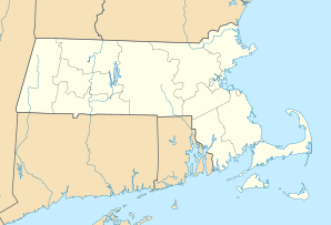
| Location in Massachusetts | ||
|
|
||
| Basic data | ||
| Foundation : | 1655 | |
| State : | United States | |
| State : | Massachusetts | |
| County : | Essex County | |
| Coordinates : | 42 ° 42 ′ N , 71 ° 10 ′ W | |
| Time zone : | Eastern ( UTC − 5 / −4 ) | |
| Residents : | 76,377 (as of 2010) | |
| Population density : | 4,243.2 inhabitants per km 2 | |
| Area : | 19.2 km 2 (approx. 7 mi 2 ) of which 18.0 km 2 (approx. 7 mi 2 ) are land |
|
| Height : | 14 m | |
| Postcodes : | 01840-01843 | |
| Area code : | +1 978,351 | |
| FIPS : | 25-34550 | |
| GNIS ID : | 619449 | |
| Website : | www.cityoflawrence.com | |
| Mayor : | William Lantigua | |
Lawrence is a city on the Merrimack River in Essex County in the US state of Massachusetts in the United States . In 2010 the population was 76,377 people.
history
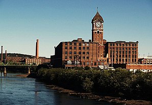
Lawrence was founded around 1840 and is considered the first planned industrial city in the United States. In 1847 it was given town status and in 1853 as a city .
The city was an important location for the textile industry, which produced here for both the American and the European market. At the beginning of the twentieth century with a population of almost 95,000, Lawrence was a leader in the manufacture of cotton and wool textiles. The factories operated by the hydropower of the Merrimack River played a major role here. The ESSEX Company, led by Abbot Lawrence, dammed the river with the Great Stone Dam . Previously known as New City , Essex or Merimac , it was named in honor of the entrepreneur in Lawrence in 1853.
The Pemberton Mill ( Pemberton Mill ) crashed on January 10, 1860 without warning one, it is estimated that 145 workers were killed and another 166 were injured.
In the mid to late 19th century, many people in search of work turned to Lawrence. They came from almost every European nation, v. a. but from Ireland, France, Italy, Germany, Belgium, Poland and Lithuania. There were also French Canadians from the provinces of Quebec , New Brunswick and Prince Edward Iceland . At that time, Lawrence was considered an immigrant city and, despite its small area of only 15.5 km² (6 mi²) at the time, had more immigrants per inhabitant from all over the world than any other comparable place in the world.
Demographics
| Population development | |||
|---|---|---|---|
| Census | Residents | ± in% | |
| 1850 | 8282 | - | |
| 1860 | 17,639 | 113% | |
| 1870 | 28,921 | 64% | |
| 1880 | 39,151 | 35.4% | |
| 1890 | 44,654 | 14.1% | |
| 1900 | 62,559 | 40.1% | |
| 1910 | 85,892 | 37.3% | |
| 1920 | 94,270 | 9.8% | |
| 1930 | 85,068 | -9.8% | |
| 1940 | 84,323 | -0.9% | |
| 1950 | 80,536 | -4.5% | |
| 1960 | 70,933 | -11.9% | |
| 1970 | 66,915 | -5.7% | |
| 1980 | 63.175 | -5.6% | |
| 1990 | 70.207 | 11.1% | |
| 2000 | 72,043 | 2.6% | |
| 2010 | 76,377 | 6% | |
According to the United States Census 2010 , 76,377 people lived in 25,181 households, there were 17,501 families. The population consisted of 42.8% white, 7.6% black and 2.5% Asian. 73.8% had Hispanic or Latino roots . The per capita income was $ 16,557.
Lawrence had reached its preliminary peak in population in 1920 with 94,270 inhabitants (see table), after which the population declined over the next 60 years. From 1980 onwards, growth began again and has continued to this day. The emigration from 1920 was mainly due to the weak economic situation of the city at that time, in 1912 there was the so-called 1912 Lawrence Textile Strike .
traffic
Lawrence is on Interstate 495 . Massachusetts Route 28 also traverses the city from south to north. Massachusetts Route 110 runs east to west in the northern part of Lawrence. Massachusetts Route 114 can be accessed through Route 28. This means that the road network in and around the city is well developed.
The nearest airport is the very small Lawrence Municipal Airport . a. used for the transport of sick people, medicines as well as blood and organ donations. Lawrence is roughly halfway between Manchester-Boston Regional Airport and Logan International Airport .
Personalities
sons and daughters of the town
- John K. Tarbox (1838-1887), politician
- Ernest Thayer (1863–1940), poet
- Robert S. Maloney (1881–1934), politician
- Laurence Allen Abercrombie (1897–1973), Rear Admiral
- Thomas J. Lane (1898–1994), politician
- Thelma Todd (1906-1935), actress
- Leonard Bernstein (1918–1990), composer and conductor
- Irene Daye (1918–1971), jazz singer
- Andrew Augustine Caffrey (1920–1993), lawyer, federal judge for Massachusetts
- Endicott Peabody (1920–1997), politician, Governor of Massachusetts
- Leo Penn (1921–1998), director and actor
- Philip J. Davis (1923–2018), mathematician and writer
- William John McNaughton (1926–2020), Catholic religious, Bishop of Incheon
- Robert Goulet (1933–2007), singer and actor
- William Joseph Justice (* 1942), auxiliary bishop emeritus in San Francisco
- Paul Monette (1945–1995), author, poet and LGBT activist
- J. Bonnie Newman (* 1945), politician and university professor
- Joe Perry (born 1950), lead guitarist for the band Aerosmith
- Robbie Merrill (* 1963), bass player in the band Godsmack
- Sully Erna (* 1968), singer, guitarist and drummer in the band Godsmack
- Statik Selektah (* 1982), hip-hop DJ and producer
Other personalities
- Robert Frost (1874–1963), poet, lived in Lawrence as a child
- William Shadrach Knox (1843–1914), politician, died in Lawrence
- Abbott Lawrence (1792–1855), businessman and politician, namesake of the city (whether he has ever set foot is uncertain)
- William A. Russell (1831–1899), politician, lived in Lawrence from 1852
- James Michael Shannon (* 1952), politician, lawyer in Lawrence from 1975
See also
Web links
Individual evidence
- ^ Immigrant City: Lawrence, Massachusetts, 1845-1921 by Donald B. Cole
- ↑ http://www.city-data.com/city/Lawrence-Massachusetts.html
- ↑ Archived copy ( memento of the original from August 25, 2012 in the Internet Archive ) Info: The archive link was inserted automatically and has not yet been checked. Please check the original and archive link according to the instructions and then remove this notice.
- ↑ The Great Stone Dam ( Memento of the original from March 4, 2016 in the Internet Archive ) Info: The archive link was inserted automatically and has not yet been checked. Please check the original and archive link according to the instructions and then remove this notice. , Essex County home page, accessed April 1, 2014
- ↑ The Fall of the Pemberton Mill
- ↑ http://factfinder2.census.gov/bkmk/table/1.0/en/DEC/10_DP/DPDP1/1600000US2534550
- ↑ http://factfinder2.census.gov/bkmk/table/1.0/en/ACS/10_5YR/DP03/1600000US2534550
