List of architectural monuments in Oberhausen
The list of architectural monuments in Oberhausen contains the listed buildings in the area of the city of Oberhausen in North Rhine-Westphalia (as of May 17, 2016). These monuments are entered in the list of monuments of the city of Oberhausen; The basis for the admission is the Monument Protection Act North Rhine-Westphalia (DSchG NRW).
List of architectural monuments in Oberhausen
| image | designation | location | description | construction time | Registered since |
Monument number |
|---|---|---|---|---|---|---|
 more pictures |
Bert Brecht House | Alt-Oberhausen Langemarkstrasse 19, 21 Paul-Reusch-Strasse 34, 36 Map |
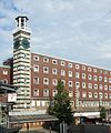
1. City skyscraper. July 1924: closer architectural competition by the newspaper publisher "Ruhrwacht". 1st prize: Architect: Otto Scheib , Cologne. From April 1925 to December 1926, the two wing buildings "Ruhrwachthaus" were built as residential and commercial buildings with a printing and editorial office. Instead of the planned high-rise office tower, the seven-story “ Tietz ” department store will be built between August 1927 and October 1928 . After the 2nd World War it became " Kaufhof ", remodeling in 1982 by the city. Today administration building with adult education center and city library. | 1925-1928 | March 13, 1985 | 1
|
 more pictures |
former Altenberg zinc factory | Hansastrasse 18 map |
The former factory buildings now form the cultural center "Altenberg" and the LVR-Industriemuseum Oberhausen ( Rheinisches Industriemuseum ). | from 1900 | 2
|
|

|
Administration building | Danziger Strasse 11 map |
former employment office | 1929 | 3
|
|
 more pictures |
Villa Concordia / Meuthenvilla | Grillostrasse 34 map |
1897 | 4th
|
||
| Gustavstrasse settlement | Gustavstrasse 102–118, 113–117 map |
1892 | 5
|
|||
 more pictures |
Oberhausen water tower | Mülheimer Strasse 1 map |
1897 | 6th
|
||

|
Town hall Sterkrade | Steinbrinkstrasse 186, 188 map |
1888 | 7th
|
||
 more pictures |
Grafenbusch settlement | Am Grafenbusch 1–17, 2–52 map |
in several construction phases based on designs by Bruno Möhring | 1910-1923 | 8th
|
|

|
Bakehouse | Palatinate Street map |
around 1850 | 9
|
||
 more pictures |
Vondern Castle | Arminstrasse 65 map |
around 1520 | 10
|
||

|
Former railway operations building of Osterfeld-Nord station | Rothebuschstraße 2 map |
used today as a Waldorf kindergarten | - | 11
|
|
| former residential stable building | Hamborner Allee 39 map |
- | 12
|
|||

|
Oberhausen District Court | Friedensplatz 1 card |
1904-1907 | 14th
|
||

|
former Sterkrade police station | Wilhelmplatz 2 map |
Service building with police prison and apartments; built by the state building administration, project management by government master builder Frenzel | 1925-1927 | 15th
|
|

|
Catholic Church of St. Michael and rectory | Falkensteinstraße 234 Pothmannsweg map |
1928-1929 | 16
|
||
 more pictures |
Evangelical Martin Luther Church | Lipperheidstrasse 55 map |
1898-1899 | 17th
|
||
| Zeppelin House | Veilchenweg 6, 8 map |
- | 20th
|
|||
| Residential and inn , former "Bürgererkrug" | Stöckmannstrasse 115 Hermann-Albertz-Strasse 65 map |
- | 21st
|
|||

|
Residential building | Lohstrasse 116 map |
- | 22nd
|
||
 more pictures |
Catholic parish church of St. Marien | Elsa-Brändström-Strasse 85 map |
Architect Freiherr Friedrich von Schmidt (1825-1891) | 1894 | 23
|
|
| Ruhrlandhaus | Willy-Brandt-Platz 2 card |
1931-1932 | 24
|
|||

|
Evangelical Christ Church | Nohlstrasse 7 map |
1863-1864 | 25th
|
||

|
Evangelical parish hall | Nohlstrasse 2 Danzinger Strasse 9 map |
1875/1911 | 26th
|
||

|
School building of the Adolf-Feld-Schule | Nohlstrasse map |
Together with monument number 71, it forms the school building of the Adolf-Feld-Schule | - | 27
|
|
| Old power station | Danziger Strasse 31 map |
- | 28
|
|||

|
Residential and commercial building | Grillostrasse 14 Schwartzstrasse 62 map |
former Stadtsparkasse, architect: Friedrich Pützer | 1911-1912 | 29
|
|

|
Catholic parish church Herz Jesu | Marktstrasse 34 map |
1909-1911 | 30th
|
||

|
Catholic Parish Church of St. Joseph | Lothringer Straße 154 Martin-Heix-Platz map |
Architect Freiherr Friedrich von Schmidt (1825-1891) | 1871-1874 | 31
|
|

|
War memorial and former victory column | Old market card |
1876 | 32
|
||

|
Evangelical Paulus Church | Duisburger Strasse 331 map |
1905-1906 | 33
|
||

|
Catholic Church of St. Joseph | Buschhausen Lindnerstrasse map |
- | 34
|
||

|
Tower windmill | Holten Siegesstrasse 149 map |
1838 | 35
|
||
 more pictures |
Dunkelschlag settlement | Sterkrade Dammstrasse 1–21, 2–22, 30–34 Erzstrasse 1–9, 2–10 Grubenstrasse 2–12 Schachtstrasse 1–7 Weierstrasse 167–171 Weseler Strasse 207–211 Zechenstrasse 1–13, 2–16 map |
- | 36
|
||

|
"Hagelkreuz" wayside cross | Buschhausen Hagelkreuzstrasse Westmarkstrasse map |
- | 37
|
||
| Catholic Church of St. Joseph | Osterfeld Vestische Strasse 112 map |
1909-1910 | 38
|
|||
 more pictures |
Catholic parish church of St. Pankratius | Osterfeld Bottroper Strasse 173 map |
1893-1895 | 39
|
||
 more pictures |
former Gutehoffnungshütte (GHH III) | Essener Strasse 21, 66, 80 map |
also includes the "Tor 16" (formerly GHH vehicle fleet) Architect: Peter Behrens , the order was preceded by an architectural competition with Carl Weigle , Grunitz, Bruno Möhring and Peter Behrens . ( ⊙ ), GHH headquarters III and the main warehouse of GHH with the single-storey warehouse for oils and fats ( ⊙ ) | 1921-1925 | 40
|
|
 more pictures |
Fort Holten | Kastellstrasse 56 map |
- | 41
|
||
|
more pictures |
Oberhausen Castle | Konrad-Adenauer-Allee 46, 48 map |
Reconstruction of the main house in 1960 | 42
|
||
 more pictures |
Oberhausen town hall | Schwartzstrasse 72 map |
Architects: Alderman Eduard Jüngerich and City Builder Ludwig Freitag | 1927-1930 | 43
|
|

|
Former head office of Gutehoffnungshütte , today's administration building | Essener Strasse 55 map |
- | 44
|
||

|
Hospital facility of the Johanniter Hospital | Sterkrade Steinbrinkstrasse 96a map |
- | 45
|
||
| Corner block development | Rheinische Strasse 22, 24 Vestische Strasse 28 map |
- | 46
|
|||
| Kiepen's yard | Flugelstrasse 132 map |
around 1800 | 47
|
|||
 more pictures |
Steel construction of gate 8 of the former Gutehoffnungshütte | Essener Strasse map |
around 1850 | 48
|
||
 more pictures |
former Ebertbad | Ebertplatz 4 card |
The Ebertbad was the first public bathing establishment in Oberhausen and has been used as an event venue since the end of 1989. Plans by Albert Regelmann |
1894/95 | 49
|
|
 more pictures |
Factory inn of the former Gutehoffnungshütte | Essener Strasse 3 map |
Architect: Carl Weigle | 1913-1914 | 50
|
|
| former "Magis" department store | Marktstraße 43 Paul-Reusch-Straße map |
original textile store Rüttgers, later Magis; 1st construction phase 1912, 2nd construction phase 1928; Architect: Otto Engler | 1912, 1928 | 51
|
||
 more pictures |
St. Antony Hut : former administration building | Antoniestraße 32, 34 map |
Single-storey half-timbered house with extensions, former house of the hut manager of the oldest ironworks in the Ruhr area. Today LVR museum | 1758 | 52
|
|

|
Builder Mill and Residential Buildings | Homberger Strasse 11 map |
- | 53
|
||

|
Catholic parish church of St. Johann Baptist | Bahnstrasse 234 map |
- | 54
|
||

|
Jewish Cemetery | Holten Siegesstraße Vennstraße map |
- | 55
|
||

|
City center house: bell tower | Steinbrinkstrasse 215 map |
1931 | 56
|
||

|
Residential and guest house | Leuthenstrasse 96, 98 Von-Trotha-Strasse 71, 73 map |
former restaurant "Schützenhof" | - | 57
|
|
| Parish hall of St. Pankratius | Nuernberger Strasse 6 map |
former isolation house of the Marienhospital | - | 58
|
||
 more pictures |
Oberhausen main station : reception building with a former water tower | Willy-Brandt-Platz 1 card |
1929-1934 | 59
|
||
| Police Headquarters | Friedensplatz 2, 3, 4, 5 card |
- | 60
|
|||
| former main post office | Poststrasse 1, 1a Paul-Reusch-Strasse 2 map |
- | 61
|
|||
| Half-timbered house | Speldorfer Strasse 63 map |
Mid-18th century | 1750 | 62
|
||
| School building of the Elsa-Brändström-Gymnasium | Christian-Steger-Strasse 11 map |
→ see monument number 67, former state high school |
- | 63
|
||

|
Osterfeld town hall | Bottroper Strasse 183 map |
1894 | 64
|
||

|
former forester's house | To Ravenhorst 91 card |
- | 65
|
||
| Residential and office buildings | Paul-Reusch-Straße 56 map |
- | 66
|
|||

|
School building of the Elsa-Brändström-Gymnasium | Christian-Steger-Strasse 8, 10 map |
→ see also monument number 63 to 1928 Police Directorate Oberhausen-Mülheim, former Hans Sachs vocational school |
1923 | 67
|
|

|
Half-timbered house | Kewerstrasse 88 map |
former Lindermannshof | - | 68
|
|

|
Administration building | Elsa-Brändström-Straße 19 Freiherr-vom-Stein-Straße 50 map |
last social house, previous school building (lyceum, Elsa-Brändström-Gymnasium), former Reichsbank | - | 69
|
|

|
School building of the former Falkenstein School | Liebknechtstrasse 72 Martin-Luther-Strasse map |
today part of the Berta von Suttner high school | - | 70
|
|

|
School building of the Adolf-Feld-Schule | Danziger Strasse 7 map |
Together with monument number 27, it forms the listed school building of the Adolf-Feld-Schule | - | 71
|
|
| Residential and commercial buildings | Friedensplatz 13, 14, 15, 16 Poststrasse 7 map |
- | 72
|
|||
| Residential building | Ebertplatz 8 Sedanstraße 54 map |
- | 73
|
|||
| Residential building | Ebertplatz 2 card |
- | 74
|
|||

|
former synagogue | Mechthildisstrasse 7a map |
- | 75
|
||
| Rectory | Martin-Luther-Strasse 40 map |
- | 76
|
|||

|
Zion Baptist Church | Walter-Flex-Strasse 13 map |
1907 | 77
|
||

|
Evangelical Luther Church | Buschhausen Thuringer Strasse 21 map |
1913 | 78
|
||
| Kaisergarten: large boulder | Konrad-Adenauer-Allee | - | 79
|
|||
| Kaisergarten: boulder at the pond | Konrad-Adenauer-Allee | - | 80
|
|||
| Kaisergarten: foundling | Konrad-Adenauer-Allee | - | 81
|
|||

|
Deer plastic | Sterkrade Finkenweg map |
Cast iron deer in Volkspark Sterkrade | 1904 | 82
|
|

|
Catholic parish church of St. Antonius | Klosterhardter Strasse Memelstrasse map |
- | 83
|
||
 more pictures |
Eisenheim settlement | Berliner Strasse 4–20 Eisenheimer Strasse 1–11, 2–8 Fuldastrasse 5, 7, 11, 13 Werrastrasse 1–7, 2–10 Wesselkampstrasse 19–35, 39–43 Map |
- | 84
|
||

|
Residential building | Hofstrasse 22 map |
- | 85
|
||
| Evangelical Resurrection Church with rectory | Vestische Strasse 86, 88 map |
- | 86
|
|||

|
School building of the Schlad School | Schladstrasse 26 map |
- | 87
|
||

|
Catholic Church of St. Bernardus | Dorstener Strasse 188 map |
- | 88
|
||
| Marienhospital: chapel | Nuernberger Strasse 10 map |
- | 89
|
|||

|
School building of the Freiherr-vom-Stein-Gymnasium | Wilhelmstrasse 77 map |
- | 90
|
||

|
Villa Reinhard | Schwartzstrasse 71 map |
“Kulturvilla”, former seat of the adult education center; built for the entrepreneur Hugo Reinhard (grandson of Wilhelm Grillo); Architect: Eduard Lyonel Wehner (Düsseldorf) | 1921-1923 | 91
|
|

|
Residential stable building | Service route 120 card |
former Kotte | - | 92
|
|

|
School building of the Steinbrink School | Steinbrinkstrasse 166 map |
- | 93
|
||

|
Evangelical Christ Church | Sterkrade Weseler Straße 105 map |
- | 94
|
||
| Residential and commercial building | Altmarkt 3 map |
- | 95
|
|||

|
Liebfrauen monastery church | Rossbachstrasse 41 map |
- | 96
|
||
 more pictures |
Evangelical Peace Church | Sterkrade Steinbrinkstrasse 162 map |
- | 97
|
||
| Statue for Franz Haniel | near Antoniestraße 32, 34 map |
opposite the St. Antony Museum, was previously near the Oberhausen colliery on Knappenstrasse | - | 98
|
||
| Lueg bust | near Antoniestraße 32, 34 | in the museum garden, sculptor: Erich Kolbe, previously stood in front of the factory inn | 1940 | 99
|
||

|
Statue for Gottlob Jacobi | near Antoniestraße 32, 34 map |
is now in Antonie-Park am Hammerteich, previously behind the GHH factory gate, Factory 1, Bahnhofstrasse | - | 100
|
|
| Granite obelisk | Landwehr 318 | Landwehr cemetery, field 6 | - | 101
|
||

|
Tomb | Landwehr 318 | Landwehr cemetery, field 17, no.397/398, 461/462 made of shell limestone |
- | 102
|
|

|
Granite obelisk | Landwehr 318 | Landwehr cemetery, field 15, no. 133/134 | - | 103
|
|
| Tailor's tomb | Emscherstrasse 72 | Westfriedhof, field 16, no. 40–44 made of sandstone |
- | 104
|
||
| Droste tomb | Emscherstrasse 72 | Westfriedhof, field 3, no. 33/34 made of sandstone |
- | 105
|
||
| Carpenter's tomb | Emscherstrasse 72 | Westfriedhof, field 9, no. 47–50 made of sandstone |
- | 106
|
||
| Tomb city | Emscherstrasse 72 | Westfriedhof, field 9, No. 23 made of pillow stone |
- | 107
|
||
| Tomb city | Emscherstrasse 72 | Westfriedhof, field 7, No. 623 made of pillow stone |
- | 108
|
||
| Wilms tomb | Emscherstrasse 72 | Westfriedhof, field 9, no. 1–5 made of sandstone |
- | 109
|
||
| Wilms tomb | Emscherstrasse 72 | Westfriedhof, field 9, no. 7/9 made of sandstone |
- | 110
|
||
| War memorial "Germania" | Emscherstraße 72 map |
Westfriedhof, field 7/9 | - | 111
|
||
| Hochkreuz | Emscherstraße 72 map |
Westfriedhof, field 5/6 made of sandstone |
- | 112
|
||

|
Warrior Memorial "Reclining Figure" | Rathenauplatz Dienststrasse Koenigstrasse map |
1928 | 113
|
||
| Residential building | Sedanstrasse 57 map |
- | 115
|
|||

|
Residential building | Kastellstrasse 15 map |
- | 116
|
||
 more pictures |
Former Osterfeld colliery : conveyor shaft IV and wash house | To the Dörnbusch map |
- | 117
|
||
| Residential building | Sedanstrasse 63 map |
- | 118
|
|||
 more pictures |
Engine shed and water tower | Card at the Kaisergarten |
- | 119
|
||
| Residential building | Annabergstrasse 47 map |
- | 120
|
|||
 more pictures |
former gasometer | Arenastraße 11 map |
1927-1929 | 121
|
||
 more pictures |
former Osterfeld colliery | Vestische Straße 41, 43, 45 Zum Steigerhaus 1 map |
Gatehouses, administration building, Steigerhaus, headframe "Paul-Reusch-Schacht" and coking coal mixing plant "Dom" | - | 122
|
|

|
Residential building | Ackerfeldstrasse 1 map |
- | 123
|
||

|
Residential building | Ackerfeldstrasse 3 map |
- | 124
|
||

|
Residential building | Ackerfeldstrasse 5 map |
- | 125
|
||

|
Residential building | Homberger Strasse 7 map |
- | 126
|
||

|
Double villa | Inselstrasse 25 map |
- | 127
|
||

|
Double villa | Inselstrasse 27 map |
- | 128
|
||
| Residential building | Robert-Koch-Strasse 35 map |
- | 129
|
|||
| Residential building | Robert-Koch-Strasse 47 map |
- | 130
|
|||
| Residential building | Annabergstrasse 30 map |
- | 131
|
|||
| Residential building | Annabergstrasse 32 map |
- | 132
|
|||
| Residential building | Annabergstrasse 34 map |
- | 133
|
|||
| Residential building | Annabergstrasse 36 map |
- | 134
|
|||
| Residential building | Annabergstrasse 36a map |
- | 135
|
|||
| Residential building | Annabergstrasse 38 map |
- | 136
|
|||
| Residential building | Annabergstrasse 39 map |
- | 137
|
|||
| School building of the Alstaden secondary school | Bebelstrasse 182 map |
- | 138
|
|||
| Half-timbered house | Hedwigstrasse 20 map |
former farm | - | 139
|
||
| School building of the Havenstein School | Küppers Hof 15 map |
1931 | 140
|
|||
| Residential building | Robert-Koch-Strasse 2 map |
- | 141
|
|||

|
Residential building | Strasbourg street 157 map |
- | 142
|
||
 more pictures |
Stemmersberg settlement | Aktienstraße 1–7, 2–8 Gutestraße 9–15, 19, 10–16 Hoffnungsstraße 1–15, 2–16 Hügelstraße 55–61, 69–79 Hüttestraße 2–16 Industriestraße 1–5, 2–6 Vereinsstraße 1–7 , 2–8 Westerwaldstrasse 10–46 Ziegelstrasse 60–66, 70–74, 61–75 map |
1900-1906 | 143
|
||
 more pictures |
Ripshorster Strasse settlement (Riwetho settlement) | Ripshorster Strasse 365–379 Thomasstrasse 1, 2, 3, 4 Werkstrasse 5–31, 6–20, 26 Map |
- | 144
|
||
| Signal box "Bro" | at Schloßstraße 49 card |
Railway operations building in the eastern part of the Oberhausen-Osterfeld marshalling yard | - | 145
|
||
| Residential building | Sedanstrasse 59 map |
- | 146
|
|||
| Courtyard building | Sedanstrasse 59 map |
- | 147
|
|||
| Residential building | Freiherr-vom-Stein-Strasse 63 map |
- | 148
|
|||

|
Gatehouse of the former Ludwigshütte | To Ludwigshütte 8 map |
- | 149
|
||

|
Factory gate of the former Ludwigshütte | To Ludwigshütte 8, 9 map |
- | 150
|
||

|
Gatehouse of the former Ludwigshütte | To Ludwigshütte 9 map |
- | 151
|
||

|
Residential building | Krumme Strasse 4 map |
- | 152
|
||
| former post office | Osterfeld Vikariestraße 12 Völklinger Straße map |
- | 153
|
|||

|
Residential building | Krumme Strasse 29 map |
- | 154
|
||
 more pictures |
former Sterkrade colliery , shaft I: headframe and shaft hall | Von-Trotha-Strasse map |
- | 155
|
||

|
Operating building of the Oberhausen West marshalling yard | Ruhrorter Strasse 40 map |
- | 156
|
||
| Europahaus | Downtown Alt-Oberhausen Langemarkstrasse 10–16 Elsässer Strasse 17–25 map |
six- or nine-story residential and commercial building, architect: Hans Schwippert (1899–1973) | 1955-1957 | 06/05/2008 | 157
|
|
 more pictures |
former Oberhausen colliery : eastern gatehouse | Essener Strasse 259 map |
Eastern gatehouse, now a hostel | 1911-1912 | 158
|
|
| Facades of the Bischof-Ketteler-Haus | Kettelerstraße 10, 12, 14 map |
South and east facades of today's old people's home, former workers' association with a single home | 1913-1915 | 160
|
||
 more pictures |
Kaisergarten | At the Kaisergarten Konrad-Adenauer-Allee card |
former Volkspark, planning by landscape architect Josef Tourneur | 1898-1906 | 12/15/2014 | 161
|
| former memorial | Lindnerstrasse 2 map |
Design competition 1936/37, 1st prize to architect Herrmann Gehrig (1904–1967) | 1938-1939 | 162
|
||

|
Schmachtendorf Evangelical Church with rectory and open spaces | Kempkenstrasse 41, 43 Am Tüsselbeck Arnoldstrasse map |
Brick church, typical building of eclecticism in the transition between historicism and art nouveau. Architect church: Heinrich Heidsiek, architect rectory: Schmenk | 1905-1906 | 163
|
|
| Catholic Parish Church of the Holy Family | Gustavstrasse 54 | - | December 10, 2019 | 164
|
||
| Muschelkalk memorial | Freiherr-vom-Stein-Str. | - | 05/17/2016 | 165
|
||
| Residential and commercial building | Gutenbergstrasse 11-13 | - | 02/14/2019 | 167
|
||
| Residential and commercial building | Langemarkstrasse 22 | - | April 17, 2019 | 169
|
||
| Residential building | Elsa-Brändström-Str. 70 | - | 02/14/2019 | 170
|
||
| Residential building | Elsa-Brändström-Str. 68 | - | 02/14/2019 | 171
|
||
| Residential and commercial building | Friedrich-Karl-Str. 4, 8; Stockmannstrasse 26, 28 | - | 02/14/2019 | 172
|
||
| Residential building | Elsa-Brändström-Str. 66 | - | March 4th, 2020 | 179
|
Former architectural monuments
| image | designation | location | description | construction time | Registered since |
Monument number |
|---|---|---|---|---|---|---|
| Zeppelin House | Rosenstrasse 130, 132 map |
tore off | - | 18th
|
||
| Zeppelin House | Blumbergstrasse 46, 48 map |
tore off | - | 19th
|
||

|
former club building "Tennis Club Recreation der GHH" | Otto-Weddigen-Strasse map |
Rest of the tennis club's perimeter wall | - | 159
|
Web links
Commons : Kulturdenkmäler in Oberhausen - Collection of pictures, videos and audio files
- City of Oberhausen - Lower Monument Authority
- List of monuments of the city of Oberhausen (PDF) Status: June 23, 2020
Individual evidence
- ↑ Zeitschrift für Bauwesen , Volume 79, 1929, Issue 7, pp. 162-164.
- ↑ Herz-Jesu-Kirche in Oberhausen is a memorial. Westdeutsche Allgemeine Zeitung , January 3, 2014, accessed on August 31, 2014 .
- ↑ Joseph Kortz: St. Joseph. www.osterfeld-westfalen.de, accessed on May 11, 2013 .
- ^ Astrid Knümann: Ketteler House in Osterfeld is to be protected as a historical monument. Westdeutsche Allgemeine Zeitung , February 18, 2014, accessed on August 30, 2014 .
