| Surname |
location |
Type |
entry |
image
|
|
Formakin House
|
near Bishopton,
55 ° 54 '20.1 " N , 4 ° 32" 42.2 " W.55.905583333333 -4.5450555555556
|
Mansion
|
10903
|

|
|
Mar Hall Hotel
|
near Erskine
55 ° 55 '15.4 " N , 4 ° 28' 43.6" W.55.920944444444 -4.4787777777778
|
hotel
|
10909
|

|
|
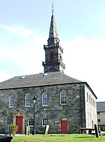
Lochwinnoch Parish Church
|
Lochwin still
55 ° 47 ′ 38 " N , 4 ° 37 ′ 42.6" W.55.793888888889 -4.6285
|
church
|
12654
|

|
|
Statues at the Houston and Kilellan Parish Church
|
Houston
55 ° 52 '14 " N , 4 ° 32" 33.4 " W.55.870555555556 -4.5426111111111
|
Statues
|
12695
|
|
|
Northbar House
|
Inchinnan
55 ° 53 '33 " N , 4 ° 25' 50.8" W.55.8925 -4.4307777777778
|
Farmhouse
|
12730
|
|
|
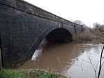
Inchinnan Bridge
|
Renfrew
55 ° 52 ′ 51.4 " N , 4 ° 24 ′ 42.4" W.55.880944444444 -4.4117777777778
|
bridge
|
12732
|

|
|
Kilbarchan Steeple
|
Kilbarchan
55 ° 50 ′ 10.1 ″ N , 4 ° 33 ′ 6.2 ″ W.55.836138888889 -4.5517222222222
|
tower
|
12839
|

|
|
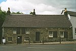
Weaver's Cottage
|
Kilbarchan
55 ° 50 '10.4 " N , 4 ° 33' 14.3" W.55.836222222222 -4.5539722222222
|
Residential buildings
|
12843
|
|
|
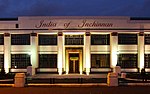
India of Inchinnan
|
Inchinnan
55 ° 53 '11 " N , 4 ° 26' 24.8" W.55.886388888889 -4.4402222222222
|
Industrial building
|
13459
|
|
|
Paisley Abbey
|
Paisley
55 ° 50 ′ 42 " N , 4 ° 25 ′ 13.1" W.55.845 -4.4203055555556
|
monastery
|
38910
|

|
|
Place of Paisley
|
Paisley
55 ° 50 ′ 40.6 " N , 4 ° 25 ′ 13.9" W.55.844611111111 -4.4205277777778
|
Rectory
|
38911
|

|
|
Domestic Finishing Mill
|
Paisley
55 ° 50 '30.7 " N , 4 ° 25' 6.8" W.55.841861111111 -4.4185555555556
|
Industrial building
|
38915
|

|
|
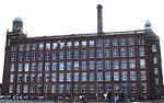
Mile End Mill
|
Paisley
55 ° 50 ′ 33.7 " N , 4 ° 24 ′ 39.5" W.55.842694444444 -4.4109722222222
|
Industrial building
|
38917
|
|
|
Blackhall Railway Viaduct
|
Paisley
55 ° 50 ′ 24.1 " N , 4 ° 24 ′ 23" W.55.840027777778 -4.4063888888889
|
bridge
|
38923
|
|
|
Russell Institute
|
Paisley
55 ° 50 ′ 36.5 " N , 4 ° 25 ′ 26" W.55.843472222222 -4.4238888888889
|
clinic
|
38944
|
|
|
Paisley High Church
|
Paisley
55 ° 50 ′ 46.3 " N , 4 ° 25 ′ 41.6" W.55.846194444444 -4.4282222222222
|
church
|
38946
|
|
|
Christian Social Action Center
|
Paisley
55 ° 50 '44.9 " N , 4 ° 25' 38.4" W.55.845805555556 -4.4273333333333
|
church
|
38948
|

|
|
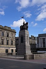
Paisley War Memorial
|
Paisley
55 ° 50 ′ 44.3 " N , 4 ° 25 ′ 26.5" W.55.845638888889 -4.4240277777778
|
monument
|
38953
|
|
|
George A. Clark Town Hall
|
Paisley
55 ° 50 ′ 43.1 " N , 4 ° 25 ′ 18.2" W.55.845305555556 -4.4217222222222
|
Administration building
|
38978
|

|
|
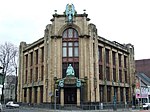
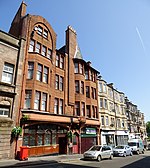
7 Gilmour Street
|
Paisley
55 ° 50 ′ 45.8 " N , 4 ° 25 ′ 26.3" W.55.846055555556 -4.4239722222222
|
Credit institution
|
38994
|
|
|
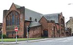
St Matthew's Church
|
Paisley
55 ° 50 ′ 32.9 " N , 4 ° 25 ′ 18.1" W.55.842472222222 -4.4216944444444
|
church
|
39007
|
|
|
Hawkhead Hospital, Buildings 7 + 8
|
Paisley
55 ° 50 ′ 3.9 " N , 4 ° 23 ′ 29.1" W.55.834416666667 -4.3914166666667
|
clinic
|
39011
|

|
|
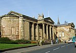
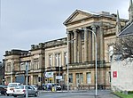
Paisley Museum
|
Paisley
55 ° 50 '43.1 " N , 4 ° 25' 48.9" W.55.845305555556 -4.43025
|
museum
|
39025
|
|
|
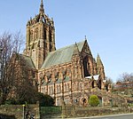
Coats Memorial Church
|
Paisley
55 ° 50 ′ 41.3 " N , 4 ° 25 ′ 56.8" W.55.844805555556 -4.4324444444444
|
church
|
39027
|
|
|
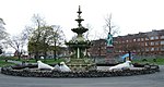
Fountain on Love Street
|
Paisley
55 ° 51 ′ 1.3 " N , 4 ° 25 ′ 42" W.55.850361111111 -4.4283333333333
|
Fountain
|
39035
|
|
|
Crosbie
|
Paisley
55 ° 49 ′ 42.5 " N , 4 ° 26 ′ 50.3" W.55.828472222222 -4.4473055555556
|
villa
|
39049
|
|
|
The Bull Inn
|
Paisley
55 ° 50 ′ 40.9 " N , 4 ° 25 ′ 34.2" W.55.844694444444 -4.4261666666667
|
Restaurant, residential building
|
39058
|
|
|
John Neilson Institution
|
Paisley
55 ° 50 '42.9 " N , 4 ° 26' 2.2" W.55.84525 -4.4339444444444
|
school
|
39069
|

|
|
Coats Observatory
|
Paisley
55 ° 50 ′ 44.6 " N , 4 ° 25 ′ 51.9" W.55.845722222222 -4.4310833333333
|
observatory
|
39072
|

|
|
Paisley Courthouse
|
Paisley
55 ° 50 ′ 55 " N , 4 ° 25 ′ 36.4" W.55.848611111111 -4.4267777777778
|
Courthouse
|
39103
|
|
|
Statues in the Renfrew Old Parish Church
|
Renfrew
55 ° 52 ′ 40.5 " N , 4 ° 23 ′ 11.3" W.55.877916666667 -4.3864722222222
|
Statues
|
40417
|
|
|
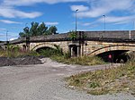
White Cart Bridge
|
Renfrew
55 ° 52 ′ 48.6 " N , 4 ° 24 ′ 37.2" W.55.880166666667 -4.4103333333333
|
bridge
|
40424
|
|
|
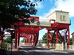
Swing bridge from Renfrew
|
Renfrew
55 ° 52 ′ 48 " N , 4 ° 24 ′ 32.8" W.55.88 -4.4091111111111
|
bridge
|
40425
|
|
|
Renfrew Town Hall
|
Renfrew
55 ° 52 ′ 44.3 " N , 4 ° 23 ′ 14" W.55.878972222222 -4.3872222222222
|
town hall
|
40430
|

|
|
Penilee Sports Pavilion
|
Paisley
55 ° 50 '55.9 " N , 4 ° 22' 44.4" W.55.848861111111 -4,379
|
Sports facility
|
43679
|
|


.jpg)

.jpg)


.jpg)


.jpg)


